
FCCInfo.com
A Service of Cavell, Mertz & Associates, Inc.
(855) FCC-INFO
|
|
KGPX-TV from 06/12/1998 KGPX-TV from 05/15/1998 |
Virtual Channel 34 |  |
|
||||||||||||||||||||||||
|
|
Repacking Information: No changes Status: License Application Accepted: 02/14/2019 License Expires: 02/01/2023 File Number: -0000067901 FCC Website Links: LMS Facility Details This Application Other KGPX-TV Applications Including Superseded Applications Mailing Address Correspondence for KGPX-TV Correspondence related to application -0000067901 Service Contour - Open Street Map or USGS Map (41 dBu) Service Contour - KML / Google Earth (41 dBu) Public Inspection Files Rabbit Ears Info Search for KGPX-TV Site Location: 47-35-35.0 N 117-17-50.0 W (NAD 83) Site Location: 47-35-35.4 N 117-17-46.3 W (Converted to NAD 27) ERP: 60 kW Polarization: Elliptically polarized HAAT: 464.59 m (1524 ft.) Electrical Beam Tilt: 1.5 degrees R/C AGL: 65.6 m (215 ft.) R/C AMSL: 1168.6 m (3834 ft.) Site Elevation: 1103 m. (3619 ft.) Height Overall*: 107.4 m (352 ft.) (* As Filed In This Application, may differ from ASR Data, Below.) Directional Antenna - Antenna Make/Model: DIELECTRIC TLP-12W/VP-R Antenna ID: 1004639 Polarization: Elliptically polarized
| |||||||||||||||||||||||||||
| Antenna Data for Antenna Id: 1004639 KGPX-TV DT File: -0000067901 DIELECTRIC - TLP-12W/VP-R Service: DT Standard Pattern: N | 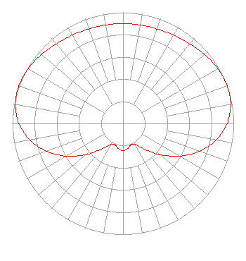 | |||||||||||||||||||||||||||
| Azimuth | Ratio | Azimuth | Ratio | Azimuth | Ratio | Azimuth | Ratio | |||||||||||||||||||||
| 0 | 0.899 | 10 | 0.900 | 20 | 0.905 | 30 | 0.917 | |||||||||||||||||||||
| 40 | 0.936 | 50 | 0.963 | 60 | 0.988 | 70 | 1.000 | |||||||||||||||||||||
| 80 | 0.987 | 90 | 0.940 | 100 | 0.854 | 110 | 0.733 | |||||||||||||||||||||
| 120 | 0.588 | 130 | 0.437 | 140 | 0.302 | 150 | 0.218 | |||||||||||||||||||||
| 160 | 0.207 | 170 | 0.232 | 180 | 0.245 | 190 | 0.232 | |||||||||||||||||||||
| 200 | 0.207 | 210 | 0.218 | 220 | 0.302 | 230 | 0.437 | |||||||||||||||||||||
| 240 | 0.588 | 250 | 0.733 | 260 | 0.854 | 270 | 0.940 | |||||||||||||||||||||
| 280 | 0.987 | 290 | 1.000 | 300 | 0.988 | 310 | 0.963 | |||||||||||||||||||||
| 320 | 0.936 | 330 | 0.917 | 340 | 0.905 | 350 | 0.900 | |||||||||||||||||||||
Structure Registration Number 1060807 Structure Type: GTOWER Registered To: Vertical Bridge CC FM, LLC Structure Address: Atop Tower Mountain And End Of Jameson Rd. / Us-wa-5039 Spokane, WA County Name: Spokane County ASR Issued: 07/23/2020 Date Built: 04/01/1995 Site Elevation: 1103 m (3619 ft.) Structure Height: 106.7 m (350 ft.) Height Overall: 107.4 m (352 ft.) Overall Height AMSL: 1210.4 m (3971 ft.) FAA Determination: 05/04/2020 FAA Study #: 2020-ANM-1267-OE FAA Circular #: 70/7460-1L Paint & Light FAA Chapters: 4, 8, 12 PRIOR STUDY 2016-ANM-646-OE 47-35-35.0 N 117-17-50.0 W (NAD 83) 47-35-35.4 N 117-17-46.3 W (Converted to NAD 27) |
3110 W California Avenue, Suite C Salt Lake City, UT 84104 Phone: 435-414-1338 Limited Liability Company | Title: Director, Support Engineering Date: 02/14/2019 Application Certifier ION TELEVISION LICENSE, LLC Ion Television License, Llc 601 Clearwater Park Road West Palm Beach, FL 33401 Applicant Bianca Frye Ion Media Networks, Inc. 601 Clearwater Park Road West Palm Beach, FL 33401 Mark Ruppert Ion Media Networks, Inc. 14444 66th Street N Clearwater, FL 33764 Director, Support Engineering | ||||||||||||||||||||||||||
| ||||||||||||||||||||||||||||