
FCCInfo.com
A Service of Cavell, Mertz & Associates, Inc.
(855) FCC-INFO
|
|
W23EQ-D from 03/21/2019 W23EQ-D from 03/11/2009 W23EQ-D from 04/26/2002 |
|
|
||||||||||||||||
|
|
Status: License Application Accepted: 03/19/2019 License Expires: 12/01/2021 File Number: -0000068569 FCC Website Links: LMS Facility Details This Application Other W23EQ-D Applications Including Superseded Applications Mailing Address Correspondence for W23EQ-D Correspondence related to application -0000068569 Service Contour - Open Street Map or USGS Map (51 dBu) Service Contour - KML / Google Earth (51 dBu) Rabbit Ears Info Search for W23EQ-D Site Location: 40-09-05.8 N 87-42-48.8 W (NAD 83) Site Location: 40-09-05.7 N 87-42-48.7 W (Converted to NAD 27) ERP: 12.1 kW Polarization: Elliptically polarized Electrical Beam Tilt: 1.0 degree R/C AGL: 141.3 m (464 ft.) R/C AMSL: 347 m (1138 ft.) Emission Mask: Full Service Site Elevation: 205.7 m. (675 ft.) Height Overall*: 147.2 m (483 ft.) (* As Filed In This Application, may differ from ASR Data, Below.) Directional Antenna - Antenna Make/Model: Alive Telecom ATC-BCE48C1R-V2-23 Antenna ID: 1004749 Polarization: Elliptically polarized
| ||||||||||||||||||
| Antenna Data for Antenna Id: 1004749 W23EQ-D LD File: -0000068569 Alive Telecom - ATC-BCE48C1R-V2-23 Service: LD Standard Pattern: N | 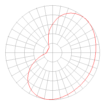 | ||||||||||||||||||
| Azimuth | Ratio | Azimuth | Ratio | Azimuth | Ratio | Azimuth | Ratio | ||||||||||||
| 0 | 0.594 | 10 | 0.757 | 20 | 0.876 | 30 | 0.952 | ||||||||||||
| 40 | 0.990 | 48 | 1.000 | 50 | 0.997 | 60 | 0.982 | ||||||||||||
| 70 | 0.956 | 80 | 0.931 | 90 | 0.914 | 100 | 0.904 | ||||||||||||
| 110 | 0.900 | 120 | 0.899 | 130 | 0.902 | 140 | 0.910 | ||||||||||||
| 150 | 0.924 | 160 | 0.946 | 170 | 0.972 | 180 | 0.993 | ||||||||||||
| 186 | 1.000 | 190 | 0.995 | 200 | 0.969 | 210 | 0.908 | ||||||||||||
| 220 | 0.806 | 230 | 0.659 | 240 | 0.481 | 250 | 0.299 | ||||||||||||
| 260 | 0.165 | 270 | 0.122 | 280 | 0.117 | 290 | 0.113 | ||||||||||||
| 300 | 0.112 | 310 | 0.116 | 320 | 0.120 | 330 | 0.148 | ||||||||||||
| 340 | 0.255 | 350 | 0.434 | ||||||||||||||||
Structure Registration Number 1008524 Structure Type: GTOWER Registered To: American Towers LLC Structure Address: 12142 Kickapoo Park Rd. (danville/kickapoo# 90158) Danville, IL County Name: Vermilion County ASR Issued: 10/06/2014 Date Built: 03/20/2002 Site Elevation: 205.7 m (675 ft.) Structure Height: 146.6 m (481 ft.) Height Overall: 147.2 m (483 ft.) Overall Height AMSL: 352.9 m (1158 ft.) FAA Determination: 09/22/2014 FAA Study #: 2014-AGL-9170-OE FAA Circular #: 70/7460-1K Paint & Light FAA Chapters: 4, 8, 12 PRIOR STUDY 2013-AGL-3295-OE CHAPTERS 4,8,12 (1K) ADD SPECIAL CONDITION FOR LIGHTING DEVIATION. 40-09-05.8 N 87-42-48.8 W (NAD 83) 40-09-05.7 N 87-42-48.7 W (Converted to NAD 27) |
405 Madison Ave. Suite 2100 Toledo, OH 43604 Phone: 419-724-6212 Corporation | Title: President And General Manager Date: 03/19/2019 Application Certifier WAND(TV) PARTNERSHIP Wand(tv) Partnership 904 Southside Drive Decatur, IL 62525 Applicant Christina H Burrow Cooley Llp 1299 Pennsylvania Avenue Nw Suite 700 Washington, DC 20004 Donald G Everist Cohen, Dippell And Everist, P.c. 1420 N Street Nw Suite One Washington, DC 20005 Technical Representative Robert Gunther Wand(tv) Partnership 904 South Side Drive Decatur, IL 62521 CHIEF ENGINEER | |||||||||||||||||