
FCCInfo.com
A Service of Cavell, Mertz & Associates, Inc.
(855) FCC-INFO
|
|
KTXD-TV from 08/25/1988 |
Post-repack Channel 23 Virtual Channel 47 |  |
|
|||||||||||||||
|
|
Repacking Information: Pre-Repack Channel: 46 Post-Repack Channel: 23 Post-Repack ERP: 377 kW Phase: 4 Completion Deadline: 8/2/2019 Find nearby TV Facilities Status: License Application Accepted: 08/12/2019 License Expires: 08/01/2022 File Number: -0000080284 FCC Website Links: LMS Facility Details This Application Other KTXD-TV Applications Including Superseded Applications Mailing Address Correspondence for KTXD-TV Correspondence related to application -0000080284 Service Contour - Open Street Map or USGS Map (41 dBu) Service Contour - KML / Google Earth (41 dBu) Public Inspection Files Rabbit Ears Info Search for KTXD-TV Site Location: 32-35-22.0 N 96-58-12.9 W (NAD 83) Site Location: 32-35-21.5 N 96-58-11.9 W (Converted to NAD 27) ERP: 1000 kW Polarization: Elliptically polarized HAAT: 494.2 m (1621 ft.) Electrical Beam Tilt: 0.8 degrees R/C AGL: 462.7 m (1518 ft.) R/C AMSL: 715.6 m (2348 ft.) Site Elevation: 252.9 m. (830 ft.) Height Overall*: 487.7 m (1600 ft.) (* As Filed In This Application, may differ from ASR Data, Below.) Directional Antenna - Antenna Make/Model: Dielectric TUM-AP-C4-14/48H-2-R-T Antenna ID: 1005388 Polarization: Elliptically polarized | ||||||||||||||||||
| Antenna Data for Antenna Id: 1005388 KTXD-TV DT File: -0000080284 Dielectric - TUM-AP-C4-14/48H-2-R-T Service: DT Standard Pattern: N | 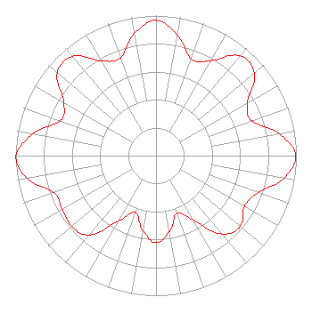 | ||||||||||||||||||
| Azimuth | Ratio | Azimuth | Ratio | Azimuth | Ratio | Azimuth | Ratio | ||||||||||||
| 0 | 0.966 | 10 | 0.876 | 20 | 0.734 | 30 | 0.782 | ||||||||||||
| 40 | 0.931 | 50 | 0.916 | 60 | 0.752 | 70 | 0.725 | ||||||||||||
| 80 | 0.893 | 90 | 0.995 | 100 | 0.926 | 110 | 0.772 | ||||||||||||
| 120 | 0.726 | 130 | 0.785 | 140 | 0.732 | 150 | 0.534 | ||||||||||||
| 160 | 0.436 | 170 | 0.550 | 180 | 0.622 | 190 | 0.543 | ||||||||||||
| 200 | 0.431 | 210 | 0.541 | 220 | 0.739 | 230 | 0.785 | ||||||||||||
| 240 | 0.772 | 250 | 0.774 | 260 | 0.932 | 269 | 1.000 | ||||||||||||
| 270 | 0.999 | 280 | 0.893 | 290 | 0.726 | 300 | 0.758 | ||||||||||||
| 310 | 0.919 | 320 | 0.927 | 330 | 0.780 | 340 | 0.742 | ||||||||||||
| 350 | 0.885 | ||||||||||||||||||
Structure Registration Number 1055009 Structure Type: GTOWER Registered To: American Towers LLC Structure Address: 1360 W. Belt Line Rd. (075253) Cedar Hill, TX County Name: Dallas County ASR Issued: 12/19/2017 Date Built: 11/04/2008 Site Elevation: 252.9 m (830 ft.) Structure Height: 442.9 m (1453 ft.) Height Overall: 487.7 m (1600 ft.) Overall Height AMSL: 740.6 m (2430 ft.) FAA Determination: 12/13/2017 FAA Study #: 2017-ASW-18744-OE Paint & Light FAA Chapters: 1, 3, 10.1, 19.1, 21 Continue As Is OM&L = PAINT/RED LIGHTS 32-35-22.0 N 96-58-12.9 W (NAD 83) 32-35-21.5 N 96-58-11.9 W (Converted to NAD 27) |
2000 W. 41st Street Baltimore, MD 21211 Phone: 410-662-9688 Corporation | Title: Secretary Date: 08/12/2019 Application Certifier GREENVILLE (KTXD-TV) LICENSEE, INC. Greenville (ktxd-tv) Licensee, Inc. 2000 W. 41st Street Baltimore, MD 21211 Applicant John E. Hidle, P.E Carl T. Jones Corporation 7901 Yarnwood Court Springfield, VA 22153-2827 Consulting Engineer Paul A. Cicelski, Esq Lerman Senter Pllc 2001 L St Nw Suite 400 Washington, DC 20036 Scott R. Flick, Esq Pillsbury Winthrop Shaw Pittman Llp 1200 Seventeenth Street, Nw Washington, DC 20036 FCC COUNSEL | |||||||||||||||||