
FCCInfo.com
A Service of Cavell, Mertz & Associates, Inc.
(855) FCC-INFO
|
|
K07AAD-D from 11/24/2008 K07AAD-D from 01/06/2004 |
|
|
||||||||||||||||
|
|
Status: STA – Special Temporary Authority Application Accepted: 07/30/2019 STA Expires: 09/23/2020 File Number: -0000067802 FCC Website Links: LMS Facility Details This Application Other K07AAD-D Applications Including Superseded Applications Mailing Address Correspondence for K07AAD-D Correspondence related to application -0000067802 Service Contour - Open Street Map or USGS Map (51 dBu) Service Contour - KML / Google Earth (51 dBu) Rabbit Ears Info Search for K07AAD-D Site Location: 32-35-22.0 N 96-58-12.9 W (NAD 83) Site Location: 32-35-21.5 N 96-58-11.9 W (Converted to NAD 27) ERP: 8 kW R/C AGL: 330 m (1083 ft.) R/C AMSL: 582.9 m (1912 ft.) Emission Mask: Stringent Site Elevation: 252.9 m. (830 ft.) Height Overall*: 487.7 m (1600 ft.) (* As Filed In This Application, may differ from ASR Data, Below.) Directional Antenna - Antenna Make/Model: MICRO COMMUNICATIONS INC 955318 Antenna ID: 20061 | ||||||||||||||||||
| Antenna Data for Antenna Id: 20061 K07AAD-D LD File: -0000067802 MICRO COMMUNICATIONS INC - 955318 Service: LD Standard Pattern: Y Pattern and Field Values Include a 320° Clockwise Rotation | 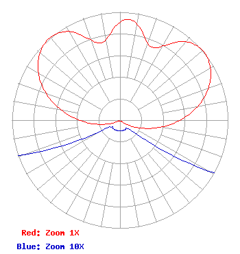 | ||||||||||||||||||
| Azimuth | Ratio | Azimuth | Ratio | Azimuth | Ratio | Azimuth | Ratio | ||||||||||||
| 0 | 0.902 | 5 | 0.933 | 10 | 0.902 | 20 | 0.756 | ||||||||||||
| 25 | 0.740 | 30 | 0.793 | 40 | 0.947 | 50 | 1.000 | ||||||||||||
| 60 | 0.967 | 70 | 0.872 | 80 | 0.729 | 90 | 0.556 | ||||||||||||
| 100 | 0.378 | 110 | 0.218 | 120 | 0.094 | 130 | 0.021 | ||||||||||||
| 140 | 0.010 | 150 | 0.010 | 160 | 0.010 | 170 | 0.010 | ||||||||||||
| 180 | 0.010 | 190 | 0.010 | 200 | 0.010 | 210 | 0.010 | ||||||||||||
| 220 | 0.010 | 230 | 0.010 | 240 | 0.021 | 250 | 0.094 | ||||||||||||
| 260 | 0.218 | 270 | 0.378 | 280 | 0.556 | 290 | 0.729 | ||||||||||||
| 300 | 0.872 | 310 | 0.967 | 320 | 1.000 | 330 | 0.947 | ||||||||||||
| 340 | 0.793 | 345 | 0.740 | 350 | 0.756 | ||||||||||||||
Structure Registration Number 1055009 Structure Type: GTOWER Registered To: American Towers LLC Structure Address: 1360 W. Belt Line Rd. (075253) Cedar Hill, TX County Name: Dallas County ASR Issued: 12/19/2017 Date Built: 11/04/2008 Site Elevation: 252.9 m (830 ft.) Structure Height: 442.9 m (1453 ft.) Height Overall: 487.7 m (1600 ft.) Overall Height AMSL: 740.6 m (2430 ft.) FAA Determination: 12/13/2017 FAA Study #: 2017-ASW-18744-OE Paint & Light FAA Chapters: 1, 3, 10.1, 19.1, 21 PRIOR STUDY 2012-ASW-2206-OE 32-35-22.0 N 96-58-12.9 W (NAD 83) 32-35-21.5 N 96-58-11.9 W (Converted to NAD 27) |
295 Madison Avenue, 12th Floor New York, NY 10017 Phone: 954-606-5486 Corporation | Title: Chief Operating Officer Date: 07/30/2019 Application Certifier Hc2 Lptv Holdings, Inc. 450 Park Avenue, 30th Floor New York, NY 10022 Applicant PAUL CICELSKI Lerman Senter Pllc 2001 L Street, Nw, Suite 400 Washington, DC 20036 LEGAL REPRESENTATIVE RENEE ILHARDT Hc2 Broadcasting Holdings 450 Park Avenue, 30th Floor New York, NY 10022 REBECCA HANSON Hc2 Broadcasting Holdings 450 Park Avenue, 30th Floor New York, NY 10022 EVP AND GENERAL COUNSEL KURT HANSON Hc2 Broadcasting Holdings Inc. 450 Park Avenue, 30th Floor New York, NY 10022 CHIEF TECHNICAL OFFICER | |||||||||||||||||