
FCCInfo.com
A Service of Cavell, Mertz & Associates, Inc.
(855) FCC-INFO
|
|
K36ON-D from 09/28/2010 |
|
|
||||||||||||||||
|
|
Status: License Application Accepted: 08/15/2019 License Expires: 10/03/2022 File Number: -0000080359 FCC Website Links: LMS Facility Details This Application Other K36ON-D Applications Including Superseded Applications Mailing Address Correspondence for K36ON-D Correspondence related to application -0000080359 Service Contour - Open Street Map or USGS Map (51 dBu) Service Contour - KML / Google Earth (51 dBu) Rabbit Ears Info Search for K36ON-D Site Location: 37-47-10.5 N 111-35-39.9 W (NAD 83) Site Location: 37-47-10.5 N 111-35-37.3 W (Converted to NAD 27) ERP: 0.09 kW Polarization: Horizontally polarized R/C AGL: 14 m (46 ft.) R/C AMSL: 1833.6 m (6016 ft.) Emission Mask: Simple Site Elevation: 1819.6 m. (5970 ft.) Height Overall*: 18.3 m (60 ft.) (* As Filed In This Application, may differ from ASR Data, Below.) Directional Antenna - Antenna Make/Model: Kathrein K72314 Antenna ID: 19753 Polarization: Horizontally polarized
| ||||||||||||||||||
| Antenna Data for Antenna Id: 19753 K36ON-D LD File: -0000080359 Kathrein - K72314 Service: LD Standard Pattern: Y Pattern and Field Values Include a 200° Clockwise Rotation | 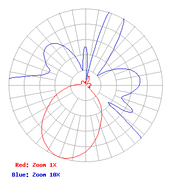 | ||||||||||||||||||
| Azimuth | Ratio | Azimuth | Ratio | Azimuth | Ratio | Azimuth | Ratio | ||||||||||||
| 0 | 0.050 | 10 | 0.010 | 20 | 0.120 | 30 | 0.100 | ||||||||||||
| 40 | 0.050 | 50 | 0.020 | 60 | 0.040 | 70 | 0.060 | ||||||||||||
| 80 | 0.070 | 90 | 0.070 | 100 | 0.060 | 110 | 0.050 | ||||||||||||
| 120 | 0.070 | 130 | 0.050 | 140 | 0.270 | 150 | 0.420 | ||||||||||||
| 160 | 0.560 | 170 | 0.730 | 180 | 0.870 | 190 | 0.960 | ||||||||||||
| 200 | 1.000 | 210 | 0.960 | 220 | 0.870 | 230 | 0.730 | ||||||||||||
| 240 | 0.560 | 250 | 0.420 | 260 | 0.270 | 270 | 0.150 | ||||||||||||
| 280 | 0.070 | 290 | 0.050 | 300 | 0.060 | 310 | 0.070 | ||||||||||||
| 320 | 0.070 | 330 | 0.060 | 340 | 0.040 | 350 | 0.020 | ||||||||||||
Structure Registration Number 1272620 Structure Type: TOWER Registered To: Garfield County Structure Address: 2.2 Miles Northwest Of Escalante, Ut Escalante, UT County Name: Garfield County ASR Issued: 01/15/2010 Date Built: 07/20/2009 Site Elevation: 1819.6 m (5970 ft.) Structure Height: 18.3 m (60 ft.) Height Overall: 18.3 m (60 ft.) Overall Height AMSL: 1837.9 m (6030 ft.) FAA Determination: 08/27/2009 FAA Study #: 2009-ANM-1382-OE Paint & Light FAA Chapters: NONE 37-47-10.5 N 111-35-39.9 W (NAD 83) 37-47-10.5 N 111-35-37.3 W (Converted to NAD 27) |
55 South Main Street Courthouse Building Panguitch, UT 84759 Phone: 435-676-1120 Government Entity | Title: Technical Representative Date: 08/15/2019 Application Certifier GARFIELD COUNTY Garfield County 55 South Main Street Courthouse Building Panguitch, UT 84759 Applicant Camille Moore Garfield County 55 South Main Street Courthouse Building Panguitch, UT 84759 Auditor/Clerk MAURI KENT PARSONS Garfield County 371 South 460 East Monroe, UT 84754 Technical Representative | |||||||||||||||||