
FCCInfo.com
A Service of Cavell, Mertz & Associates, Inc.
(855) FCC-INFO
|
|
|
Virtual Channel 4 |  |
|
||||||||||||||||||||||||||||||
|
|
Status: Construction Permit (Licensed And Reduced Power) Application Accepted: 09/04/2019 WHBF-TV CP Expires: 06/27/2021 File Number: -0000080887 FCC Website Links: LMS Facility Details This Application Other WHBF-TV Applications Including Superseded Applications Mailing Address Correspondence for WHBF-TV Correspondence related to application -0000080887 Service Contour - Open Street Map or USGS Map (51 dBu) Service Contour - KML / Google Earth (51 dBu) History Cards for WHBF-TV Rabbit Ears Info Search for WHBF-TV Site Location: 41-30-37.0 N 90-34-27.0 W (NAD 83) Site Location: 41-30-36.9 N 90-34-26.5 W (Converted to NAD 27) ERP: 0.25 kW Polarization: Horizontally polarized R/C AGL: 121.9 m (400 ft.) R/C AMSL: 293.4 m (963 ft.) Emission Mask: Full Service Site Elevation: 171.5 m. (563 ft.) Height Overall*: 152 m (499 ft.) (* As Filed In This Application, may differ from ASR Data, Below.) Directional Antenna - Antenna Make/Model: Electronics Research Inc. AL-8 Antenna ID: 94198 Polarization: Horizontally polarized | |||||||||||||||||||||||||||||||||
| Antenna Data for Antenna Id: 94198 WHBF-TV LD File: -0000080887 Electronics Research Inc. - AL-8 Service: LD Standard Pattern: Y Pattern and Field Values Include a 90° Clockwise Rotation | 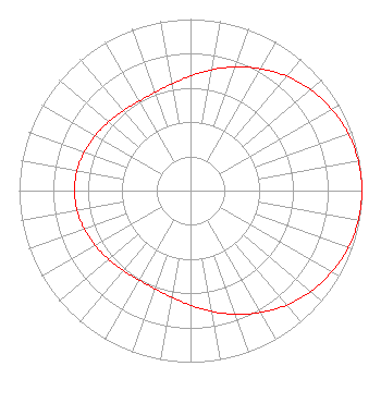 | |||||||||||||||||||||||||||||||||
| Azimuth | Ratio | Azimuth | Ratio | Azimuth | Ratio | Azimuth | Ratio | |||||||||||||||||||||||||||
| 0 | 0.668 | 10 | 0.715 | 20 | 0.767 | 30 | 0.820 | |||||||||||||||||||||||||||
| 40 | 0.871 | 50 | 0.915 | 60 | 0.951 | 70 | 0.978 | |||||||||||||||||||||||||||
| 80 | 0.994 | 90 | 1.000 | 100 | 0.994 | 110 | 0.978 | |||||||||||||||||||||||||||
| 120 | 0.951 | 130 | 0.915 | 140 | 0.871 | 150 | 0.820 | |||||||||||||||||||||||||||
| 160 | 0.767 | 170 | 0.715 | 180 | 0.668 | 190 | 0.631 | |||||||||||||||||||||||||||
| 200 | 0.609 | 210 | 0.602 | 220 | 0.608 | 230 | 0.623 | |||||||||||||||||||||||||||
| 240 | 0.642 | 250 | 0.659 | 260 | 0.672 | 270 | 0.676 | |||||||||||||||||||||||||||
| 280 | 0.672 | 290 | 0.659 | 300 | 0.642 | 310 | 0.623 | |||||||||||||||||||||||||||
| 320 | 0.608 | 330 | 0.602 | 340 | 0.609 | 350 | 0.631 | |||||||||||||||||||||||||||
Structure Registration Number 1011183 Structure Type: TOWER Registered To: Nexstar Media Inc. Structure Address: 231 18th St Rock Island, IL County Name: Rock Island County ASR Issued: 05/28/2021 Date Built: 01/01/1950 Site Elevation: 171.5 m (563 ft.) Structure Height: 126 m (413 ft.) Height Overall: 152 m (499 ft.) Overall Height AMSL: 323.5 m (1061 ft.) Paint & Light FAA Chapters: 1, 3, 4, 13, 21 41-30-37.0 N 90-34-27.0 W (NAD 83) 41-30-36.9 N 90-34-26.5 W (Converted to NAD 27) |
545 E. John Carpenter Freeway Suite 700 Irving, TX 75062 Phone: 972-373-8800 Corporation | Title: General Counsel Date: 09/04/2019 Application Certifier Nexstar Broadcasting, Inc. 545 E. John Carpenter Freeway Suite 700 Irving, TX 75062 Applicant Elizabeth Ryder Nexstar Broadcasting, Inc. 545 E John Carpenter Freeway Suite 700 Irving, TX 75062 General Counsel | ||||||||||||||||||||||||||||||||
|
| |||||||||||||||||||||||||||||||||