
FCCInfo.com
A Service of Cavell, Mertz & Associates, Inc.
(855) FCC-INFO
|
|
K14RE-D from 01/12/2007 |
|
|
||||||||||||||||
|
|
Status: License Application Accepted: 08/29/2019 License Expires: 10/03/2022 File Number: -0000080753 FCC Website Links: LMS Facility Details This Application Other K14RE-D Applications Including Superseded Applications Mailing Address Correspondence for K14RE-D Correspondence related to application -0000080753 Service Contour - Open Street Map or USGS Map (51 dBu) Service Contour - KML / Google Earth (51 dBu) Rabbit Ears Info Search for K14RE-D Site Location: 37-49-15.5 N 112-27-29.1 W (NAD 83) Site Location: 37-49-15.6 N 112-27-26.3 W (Converted to NAD 27) ERP: 0.035 kW Polarization: Horizontally polarized R/C AGL: 12 m (39 ft.) R/C AMSL: 2116.3 m (6943 ft.) Emission Mask: Simple Site Elevation: 2104.3 m. (6904 ft.) Height Overall*: 18.2 m (60 ft.) (* As Filed In This Application, may differ from ASR Data, Below.) Directional Antenna - Antenna Make/Model: Kathrein 1X2 750-10210 Antenna ID: 1005482 Polarization: Horizontally polarized
| ||||||||||||||||||
| Antenna Data for Antenna Id: 1005482 K14RE-D LD File: -0000080753 Kathrein - 1X2 750-10210 Service: LD Standard Pattern: N Pattern and Field Values Include a 85° Clockwise Rotation | 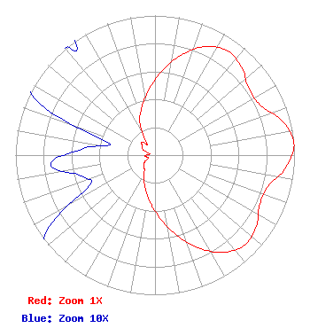 | ||||||||||||||||||
| Azimuth | Ratio | Azimuth | Ratio | Azimuth | Ratio | Azimuth | Ratio | ||||||||||||
| 5 | 0.610 | 15 | 0.745 | 25 | 0.857 | 35 | 0.911 | ||||||||||||
| 45 | 0.882 | 55 | 0.822 | 65 | 0.838 | 75 | 0.944 | ||||||||||||
| 85 | 1.000 | 95 | 0.946 | 105 | 0.844 | 115 | 0.829 | ||||||||||||
| 125 | 0.887 | 135 | 0.910 | 145 | 0.850 | 155 | 0.731 | ||||||||||||
| 165 | 0.594 | 175 | 0.459 | 185 | 0.349 | 195 | 0.257 | ||||||||||||
| 205 | 0.187 | 215 | 0.132 | 225 | 0.116 | 235 | 0.095 | ||||||||||||
| 245 | 0.052 | 255 | 0.056 | 265 | 0.075 | 275 | 0.052 | ||||||||||||
| 285 | 0.035 | 295 | 0.095 | 305 | 0.112 | 315 | 0.131 | ||||||||||||
| 325 | 0.100 | 335 | 0.258 | 345 | 0.357 | 355 | 0.473 | ||||||||||||
Structure Registration Number 1273455 Structure Type: TOWER Registered To: Garfield County Structure Address: Approx. 1 Mile West Of Panguitch, Utah. Panguitch, UT County Name: Garfield County ASR Issued: 03/09/2010 Date Built: 08/20/2009 Site Elevation: 2104.3 m (6904 ft.) Structure Height: 18.2 m (60 ft.) Height Overall: 18.2 m (60 ft.) Overall Height AMSL: 2122.5 m (6964 ft.) FAA Determination: 03/03/2010 FAA Study #: 2010-ANM-166-OE Paint & Light FAA Chapters: NONE PRIOR STUDY 2010-ANM-141-OE 37-49-15.5 N 112-27-29.1 W (NAD 83) 37-49-15.6 N 112-27-26.3 W (Converted to NAD 27) |
55 South Main Courthouse Building Panguitch, UT 84759 Phone: 435-676-8826 Government Entity | Title: Technical Representative Date: 08/29/2019 Application Certifier GARFIELD COUNTY Garfield County 55 South Main Courthouse Building Panguitch, UT 84759 Applicant Camille Moore Garfield County 55 South Main Street Courthouse Building Panguitch, UT 84759 Auditor/Clerk MAURI KENT PARSONS Garfield County 371 South 460 East Monroe, UT 84754 Technical Representative | |||||||||||||||||