
FCCInfo.com
A Service of Cavell, Mertz & Associates, Inc.
(855) FCC-INFO
|
|
K17NA-D from 01/12/2007 |
|
|
||||||||||||||||
|
|
Status: License Application Accepted: 08/29/2019 License Expires: 10/03/2022 File Number: -0000080756 FCC Website Links: LMS Facility Details This Application Other K17NA-D Applications Including Superseded Applications Mailing Address Correspondence for K17NA-D Correspondence related to application -0000080756 Service Contour - Open Street Map or USGS Map (51 dBu) Service Contour - KML / Google Earth (51 dBu) Rabbit Ears Info Search for K17NA-D Site Location: 37-49-15.5 N 112-27-29.1 W (NAD 83) Site Location: 37-49-15.6 N 112-27-26.3 W (Converted to NAD 27) ERP: 0.035 kW Polarization: Horizontally polarized R/C AGL: 13.5 m (44 ft.) R/C AMSL: 2117.8 m (6948 ft.) Emission Mask: Simple Site Elevation: 2104.3 m. (6904 ft.) Height Overall*: 18.2 m (60 ft.) (* As Filed In This Application, may differ from ASR Data, Below.) Directional Antenna - Antenna Make/Model: Kathrein 1X2 750-10210 Antenna ID: 1005485 Polarization: Horizontally polarized
| ||||||||||||||||||
| Antenna Data for Antenna Id: 1005485 K17NA-D LD File: -0000080756 Kathrein - 1X2 750-10210 Service: LD Standard Pattern: N Pattern and Field Values Include a 85° Clockwise Rotation | 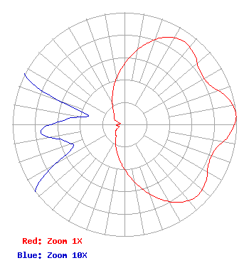 | ||||||||||||||||||
| Azimuth | Ratio | Azimuth | Ratio | Azimuth | Ratio | Azimuth | Ratio | ||||||||||||
| 5 | 0.610 | 15 | 0.745 | 25 | 0.857 | 35 | 0.911 | ||||||||||||
| 45 | 0.882 | 55 | 0.822 | 65 | 0.838 | 75 | 0.944 | ||||||||||||
| 85 | 1.000 | 95 | 0.946 | 105 | 0.844 | 115 | 0.829 | ||||||||||||
| 125 | 0.887 | 135 | 0.910 | 145 | 0.850 | 155 | 0.731 | ||||||||||||
| 165 | 0.594 | 175 | 0.459 | 185 | 0.349 | 195 | 0.257 | ||||||||||||
| 205 | 0.187 | 215 | 0.132 | 225 | 0.116 | 235 | 0.095 | ||||||||||||
| 245 | 0.052 | 255 | 0.056 | 265 | 0.075 | 275 | 0.052 | ||||||||||||
| 285 | 0.035 | 295 | 0.095 | 305 | 0.112 | 315 | 0.131 | ||||||||||||
| 325 | 0.183 | 335 | 0.258 | 345 | 0.357 | 355 | 0.473 | ||||||||||||
Structure Registration Number 1273455 Structure Type: TOWER Registered To: Garfield County Structure Address: Approx. 1 Mile West Of Panguitch, Utah. Panguitch, UT County Name: Garfield County ASR Issued: 03/09/2010 Date Built: 08/20/2009 Site Elevation: 2104.3 m (6904 ft.) Structure Height: 18.2 m (60 ft.) Height Overall: 18.2 m (60 ft.) Overall Height AMSL: 2122.5 m (6964 ft.) FAA Determination: 03/03/2010 FAA Study #: 2010-ANM-166-OE Paint & Light FAA Chapters: NONE PRIOR STUDY 2010-ANM-141-OE 37-49-15.5 N 112-27-29.1 W (NAD 83) 37-49-15.6 N 112-27-26.3 W (Converted to NAD 27) |
101 S. Wasatch Drive Salt Lake City, UT 84112 Phone: 501-585-1601 Government Entity | Title: Technical Representative Date: 08/29/2019 Application Certifier UNIVERSITY OF UTAH University Of Utah 101 S. Wasatch Drive Salt Lake City, UT 84112 Applicant MAURI KENT PARSONS University Of Utah 371 South 460 East Monroe, UT 84754 Technical Representative PHILIP Alan Titus University Of Utah 101 Wasatch Drive Salt Lake City, UT 84112 Director of Engineering | |||||||||||||||||