
FCCInfo.com
A Service of Cavell, Mertz & Associates, Inc.
(855) FCC-INFO
|
|
WYBE-CD from 09/12/2001 WYBE-CD from 03/10/1997 WYBE-CD from 10/31/1988 |
Post-repack Channel 34 |
|
||||||||||||||||
|
|
Repacking Information: Pre-Repack Channel: 44 Post-Repack Channel: 34 Post-Repack ERP: 0.09 kW Phase: 5 Completion Deadline: 9/11/2019 Upstream/Downstream Dependencies Other Linked Stations Find nearby TV Facilities Status: License Application Accepted: 09/03/2019 License Expires: 12/01/2020 File Number: -0000080833 FCC Website Links: LMS Facility Details This Application Other WYBE-CD Applications Including Superseded Applications Mailing Address Correspondence for WYBE-CD Correspondence related to application -0000080833 Service Contour - Open Street Map or USGS Map (51 dBu) Service Contour - KML / Google Earth (51 dBu) Public Inspection Files Rabbit Ears Info Search for WYBE-CD Site Location: 35-09-58.0 N 79-25-11.0 W (NAD 83) Site Location: 35-09-57.4 N 79-25-11.9 W (Converted to NAD 27) ERP: 0.09 kW Polarization: Horizontally polarized R/C AGL: 61 m (200 ft.) R/C AMSL: 207.2 m (680 ft.) Emission Mask: Simple Site Elevation: 146.2 m. (480 ft.) Height Overall*: 76.2 m (250 ft.) (* As Filed In This Application, may differ from ASR Data, Below.) Directional Antenna - Antenna Make/Model: Scala WYBE-SCACUSTOM Antenna ID: 113577 Polarization: Horizontally polarized | ||||||||||||||||||
| Antenna Data for Antenna Id: 113577 WYBE-CD DC File: -0000080833 Scala - WYBE-SCACUSTOM Service: DC Standard Pattern: Y | 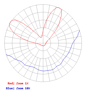 | ||||||||||||||||||
| Azimuth | Ratio | Azimuth | Ratio | Azimuth | Ratio | Azimuth | Ratio | ||||||||||||
| 0 | 0.307 | 10 | 0.638 | 20 | 0.946 | 25 | 1.000 | ||||||||||||
| 30 | 0.944 | 40 | 0.635 | 50 | 0.302 | 60 | 0.158 | ||||||||||||
| 70 | 0.105 | 80 | 0.089 | 90 | 0.077 | 100 | 0.073 | ||||||||||||
| 110 | 0.071 | 120 | 0.069 | 130 | 0.068 | 140 | 0.071 | ||||||||||||
| 150 | 0.070 | 160 | 0.073 | 170 | 0.072 | 180 | 0.072 | ||||||||||||
| 190 | 0.070 | 200 | 0.067 | 210 | 0.069 | 220 | 0.073 | ||||||||||||
| 230 | 0.074 | 240 | 0.083 | 250 | 0.094 | 260 | 0.127 | ||||||||||||
| 270 | 0.202 | 280 | 0.453 | 290 | 0.816 | 300 | 1.000 | ||||||||||||
| 310 | 0.919 | 320 | 0.459 | 330 | 0.210 | 340 | 0.153 | ||||||||||||
| 350 | 0.171 | ||||||||||||||||||
Structure Registration Number 1006461 Structure Type: TOWER Registered To: MUIRFIELD BROADCASTING INC Structure Address: Cor Short St & Long Rd Southern Pines, NC County Name: Moore County ASR Issued: 04/26/1997 Date Built: 10/01/1990 Site Elevation: 146.2 m (480 ft.) Structure Height: 75.1 m (246 ft.) Height Overall: 76.2 m (250 ft.) Overall Height AMSL: 222.4 m (730 ft.) FAA Determination: 11/12/1987 FAA Study #: 87-ASO-1892-OE FAA Circular #: 70/7460-1G Paint & Light FAA Chapters: 3, 4, 5, 9 35-09-58.0 N 79-25-11.0 W (NAD 83) 35-09-57.4 N 79-25-11.9 W (Converted to NAD 27) |
110 Torrey Pines Lane Pinehurst, NC 28374 Phone: 910-215-5686 Corporation | Title: President Multimedia Network Of Nc Inc Date: 09/03/2019 Application Certifier MULTIMEDIA NETWORK OF NC, INC Multimedia Network Of Nc, Inc 110 Torrey Pines Lane Pinehurst, NC 28374 Applicant Mark Evans, Ph.D. Multimedia Network Of North Carolina, Inc. (licensee) 110 Torrey Pines Lane Pinehurst, NC 28374 President TIMOTHY Z. SAWYER T.z. Sawyer Technical Consultants 2130 Hutchison Grove Court, Suite 100 Falls Church, VA 22043 CONSULTING ENGINEER | |||||||||||||||||