
FCCInfo.com
A Service of Cavell, Mertz & Associates, Inc.
(855) FCC-INFO
|
|
|
Post-repack Channel 34 Virtual Channel 59 |
|
||||||||||||||||
|
|
Repacking Information: Pre-Repack Channel: 42 Post-Repack Channel: 34 Post-Repack ERP: 599 kW Phase: 2 Completion Deadline: 4/12/2019 Upstream/Downstream Dependencies Other Linked Stations Find nearby TV Facilities Status: License Application Accepted: 10/10/2019 License Expires: 02/01/2021 File Number: -0000085738 FCC Website Links: LMS Facility Details This Application Other WHDT Applications Including Superseded Applications Mailing Address Correspondence for WHDT Correspondence related to application -0000085738 Service Contour - Open Street Map or USGS Map (41 dBu) Service Contour - KML / Google Earth (41 dBu) Public Inspection Files Rabbit Ears Info Search for WHDT Site Location: 26-34-30.7 N 80-14-31.1 W (NAD 83) Site Location: 26-34-29.4 N 80-14-31.9 W (Converted to NAD 27) ERP: 943.1 kW Polarization: Horizontally polarized HAAT: 440.0 m (1444 ft.) Electrical Beam Tilt: 0.75 degrees R/C AGL: 439 m (1440 ft.) R/C AMSL: 444.2 m (1457 ft.) Site Elevation: 5.2 m. (17 ft.) Height Overall*: 467 m (1532 ft.) (* As Filed In This Application, may differ from ASR Data, Below.) Directional Antenna - Antenna Make/Model: DIELECTRIC TUA-SP4-12/48H-1-S-R Antenna ID: 1004815 Polarization: Horizontally polarized | ||||||||||||||||||
| Antenna Data for Antenna Id: 1004815 WHDT DT File: -0000085738 DIELECTRIC - TUA-SP4-12/48H-1-S-R Service: DT Standard Pattern: Y | 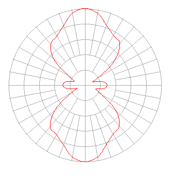 | ||||||||||||||||||
| Azimuth | Ratio | Azimuth | Ratio | Azimuth | Ratio | Azimuth | Ratio | ||||||||||||
| 0 | 1.000 | 10 | 0.952 | 20 | 0.827 | 30 | 0.747 | ||||||||||||
| 40 | 0.708 | 50 | 0.513 | 60 | 0.221 | 66 | 0.119 | ||||||||||||
| 68 | 0.119 | 70 | 0.131 | 80 | 0.247 | 90 | 0.288 | ||||||||||||
| 100 | 0.252 | 110 | 0.150 | 120 | 0.251 | 130 | 0.536 | ||||||||||||
| 140 | 0.696 | 150 | 0.738 | 160 | 0.824 | 170 | 0.951 | ||||||||||||
| 180 | 1.000 | 190 | 0.952 | 200 | 0.827 | 210 | 0.747 | ||||||||||||
| 220 | 0.708 | 230 | 0.513 | 240 | 0.221 | 247 | 0.119 | ||||||||||||
| 248 | 0.119 | 250 | 0.131 | 260 | 0.247 | 270 | 0.288 | ||||||||||||
| 280 | 0.252 | 290 | 0.150 | 300 | 0.251 | 310 | 0.536 | ||||||||||||
| 320 | 0.696 | 330 | 0.738 | 340 | 0.824 | 350 | 0.951 | ||||||||||||
Structure Registration Number 1028084 Structure Type: GTOWER Registered To: Gray Media Group, Inc. Structure Address: 12209 Homeland Rd Ext Green Acres, FL County Name: Palm Beach County ASR Issued: 02/11/2019 Date Built: 10/06/2015 Site Elevation: 5.2 m (17 ft.) Structure Height: 466 m (1529 ft.) Height Overall: 467 m (1532 ft.) Overall Height AMSL: 472.2 m (1549 ft.) FAA Determination: 10/02/2015 FAA Study #: 2015-ASO-8512-OE FAA Circular #: 70/7460-1K Paint & Light FAA Chapters: 4, 7, 12 PRIOR STUDY 1977-ASO-2132-OE 26-34-30.7 N 80-14-31.1 W (NAD 83) 26-34-29.4 N 80-14-31.9 W (Converted to NAD 27) |
312 Walnut Street 28th Floor Cincinnati, OH 45202 Phone: 513-977-3000 Limited Liability Company | Title: Vice President/engineering Date: 10/10/2019 Application Certifier SCRIPPS MEDIA, INC. Scripps Broadcasting Holdings Llc 312 Walnut Street 28th Floor Cincinnati, OH 45202 Applicant KENNETH C. HOWARD Baker & Hostetler Llp 1050 Connecticut Avenue Suite 1000 Washington, DC 20036 BENJMAIN L. PIDEK, P.E Mid-state Consultants 6197 Miller Rd., Suite 1 Swartz Creek, MI 48473 CONSULTING ENGINEER | |||||||||||||||||