
FCCInfo.com
A Service of Cavell, Mertz & Associates, Inc.
(855) FCC-INFO
|
|
KMIZ from 03/12/1979 |
Virtual Channel 17 |
|
||||||||||||||||||||||
|
|
Repacking Information: No changes Status: License Application Accepted: 11/14/2019 License Expires: 02/01/2022 File Number: -0000089534 FCC Website Links: LMS Facility Details This Application Other KMIZ Applications Including Superseded Applications Mailing Address Correspondence for KMIZ Correspondence related to application -0000089534 Service Contour - Open Street Map or USGS Map (41 dBu) Service Contour - KML / Google Earth (41 dBu) Public Inspection Files History Cards for KMIZ Rabbit Ears Info Search for KMIZ Site Location: 38-46-32.1 N 92-33-24.9 W (NAD 83) Site Location: 38-46-32.0 N 92-33-24.2 W (Converted to NAD 27) ERP: 120 kW Polarization: Horizontally polarized HAAT: 352 m (1155 ft.) Electrical Beam Tilt: 0.75 degrees R/C AGL: 326 m (1070 ft.) R/C AMSL: 575.6 m (1888 ft.) Site Elevation: 249.6 m. (819 ft.) Height Overall*: 335 m (1099 ft.) (* As Filed In This Application, may differ from ASR Data, Below.) Directional Antenna - Antenna Make/Model: R.F. Systems RD24OM488548L3S Antenna ID: 1005950 Polarization: Horizontally polarized | ||||||||||||||||||||||||
| Antenna Data for Antenna Id: 1005950 KMIZ DT File: -0000089534 R.F. Systems - RD24OM488548L3S Service: DT Standard Pattern: N | 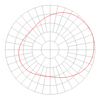 | ||||||||||||||||||||||||
| Azimuth | Ratio | Azimuth | Ratio | Azimuth | Ratio | Azimuth | Ratio | ||||||||||||||||||
| 0 | 0.766 | 10 | 0.828 | 20 | 0.882 | 30 | 0.927 | ||||||||||||||||||
| 40 | 0.954 | 50 | 0.972 | 60 | 0.989 | 70 | 1.000 | ||||||||||||||||||
| 80 | 0.989 | 90 | 0.972 | 100 | 0.954 | 110 | 0.927 | ||||||||||||||||||
| 120 | 0.882 | 130 | 0.828 | 140 | 0.766 | 150 | 0.712 | ||||||||||||||||||
| 160 | 0.663 | 170 | 0.628 | 180 | 0.606 | 190 | 0.602 | ||||||||||||||||||
| 200 | 0.612 | 210 | 0.635 | 220 | 0.663 | 230 | 0.688 | ||||||||||||||||||
| 240 | 0.703 | 250 | 0.711 | 260 | 0.703 | 270 | 0.688 | ||||||||||||||||||
| 280 | 0.663 | 290 | 0.635 | 300 | 0.612 | 310 | 0.602 | ||||||||||||||||||
| 320 | 0.606 | 330 | 0.628 | 340 | 0.663 | 350 | 0.712 | ||||||||||||||||||
Structure Registration Number 1312587 Structure Type: GTOWER Registered To: NPG of Missouri, LLC Structure Address: 5.63 Km W Jamestown, MO County Name: Moniteau County ASR Issued: 10/31/2019 Date Built: 10/30/2019 Site Elevation: 249.6 m (819 ft.) Structure Height: 333.8 m (1095 ft.) Height Overall: 335 m (1099 ft.) Overall Height AMSL: 584.6 m (1918 ft.) FAA Determination: 10/30/2019 FAA Study #: 2019-ACE-6298-OE FAA Circular #: 70/7460-1L Paint & Light FAA Chapters: 4, 9, 12 38-46-32.1 N 92-33-24.9 W (NAD 83) 38-46-32.0 N 92-33-24.2 W (Converted to NAD 27) |
825 Edmond Street St. Joseph, MO 64501 Phone: 816-271-8500 Limited Liability Company | Title: Evp And Cfo Of Parent, Npgco Date: 11/14/2019 Application Certifier NPG OF MISSOURI, LLC Npg Of Missouri, Llc C/o News-press & Gazette Co. 825 Edmond Street Saint Joseph, MO 64501 Applicant Louis R duTreil, Jr Dutreil Lundin & Rackley Inc 3135 Southgate Circle Sarasota, FL 34239 Technical Consultant Stephen Hartzell Brooks, Pierce Et Al. 150 Fayetteville Street Suite 1700 Raleigh, NC 27601 | |||||||||||||||||||||||
| |||||||||||||||||||||||||