
FCCInfo.com
A Service of Cavell, Mertz & Associates, Inc.
(855) FCC-INFO
|
|
KLJB from 08/16/1985 KLJB from 03/01/1984 |
Post-repack Channel 30 Virtual Channel 18 |  |
|
|||||||||||||||
|
|
Repacking Information: Pre-Repack Channel: 49 Post-Repack Channel: 30 Post-Repack ERP: 694 kW Phase: 7 Completion Deadline: 1/17/2020 Upstream/Downstream Dependencies Other Linked Stations Find nearby TV Facilities Status: License Application Accepted: 01/23/2020 License Expires: 02/01/2022 File Number: -0000099537 FCC Website Links: LMS Facility Details This Application Other KLJB Applications Including Superseded Applications Mailing Address Correspondence for KLJB Correspondence related to application -0000099537 Service Contour - Open Street Map or USGS Map (41 dBu) Service Contour - KML / Google Earth (41 dBu) Public Inspection Files Rabbit Ears Info Search for KLJB Site Location: 41-18-44.5 N 90-22-46.2 W (NAD 83) Site Location: 41-18-44.4 N 90-22-45.7 W (Converted to NAD 27) ERP: 1000 kW Polarization: Horizontally polarized HAAT: 328.1 m (1076 ft.) Electrical Beam Tilt: 0.6 degrees R/C AGL: 324.7 m (1065 ft.) R/C AMSL: 554.2 m (1818 ft.) Site Elevation: 229.5 m. (753 ft.) Height Overall*: 334.1 m (1096 ft.) (* As Filed In This Application, may differ from ASR Data, Below.) Directional Antenna - Antenna Make/Model: Dielectric TUF-04-14/56H-1-T Antenna ID: 1006288 Polarization: Horizontally polarized | ||||||||||||||||||
| Antenna Data for Antenna Id: 1006288 KLJB DT File: -0000099537 Dielectric - TUF-04-14/56H-1-T Service: DT Standard Pattern: N | 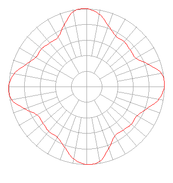 | ||||||||||||||||||
| Azimuth | Ratio | Azimuth | Ratio | Azimuth | Ratio | Azimuth | Ratio | ||||||||||||
| 0 | 1.000 | 10 | 0.942 | 20 | 0.827 | 30 | 0.751 | ||||||||||||
| 40 | 0.752 | 50 | 0.731 | 60 | 0.731 | 70 | 0.841 | ||||||||||||
| 80 | 0.974 | 90 | 1.000 | 100 | 0.942 | 110 | 0.827 | ||||||||||||
| 120 | 0.751 | 130 | 0.752 | 140 | 0.731 | 150 | 0.731 | ||||||||||||
| 160 | 0.841 | 170 | 0.974 | 180 | 1.000 | 190 | 0.942 | ||||||||||||
| 200 | 0.827 | 210 | 0.751 | 220 | 0.752 | 230 | 0.731 | ||||||||||||
| 240 | 0.731 | 250 | 0.841 | 260 | 0.974 | 270 | 1.000 | ||||||||||||
| 280 | 0.942 | 290 | 0.827 | 300 | 0.751 | 310 | 0.752 | ||||||||||||
| 320 | 0.731 | 330 | 0.731 | 340 | 0.841 | 350 | 0.974 | ||||||||||||
Structure Registration Number 1225582 Structure Type: GTOWER Registered To: American Towers LLC Structure Address: 2880 N 1100 Ave (50925) Lynn Center, IL County Name: Henry County ASR Issued: 11/16/2017 Date Built: 08/30/2001 Site Elevation: 229.5 m (753 ft.) Structure Height: 334.1 m (1096 ft.) Height Overall: 334.1 m (1096 ft.) Overall Height AMSL: 563.6 m (1849 ft.) FAA Determination: 11/08/2017 FAA Study #: 2017-AGL-19746-OE FAA Circular #: 70/7460-1L Paint & Light FAA Chapters: 3, 4, 5, 12 PRIOR STUDY 2013-AGL-7625-OE 41-18-44.5 N 90-22-46.2 W (NAD 83) 41-18-44.4 N 90-22-45.7 W (Converted to NAD 27) |
4822 Kemp Blvd Suite 300 Wichita Falls, TX 76308 Phone: 940-228-7861 Corporation | Title: President Date: 01/23/2020 Application Certifier MARSHALL BROADCASTING GROUP, INC., AS DEBTOR-IN-POSSESSION Marshall Broadcasting Group, Inc., As Debtor-in-possession 8323 Southwest Freeway Suite 433 Houston, TX 77074 Applicant Greg Best Greg Best Consulting, Inc. 16100 Outlook Avenue Stilwell, KS 66085 Consulting Engineer ALLAN G MOSKOWITZ, Esq. Allan G. Moskowitz, Esq. 10845 Tuckahoe Way North Potomac, MD 20878 | |||||||||||||||||
| |||||||||||||||||||