
FCCInfo.com
A Service of Cavell, Mertz & Associates, Inc.
(855) FCC-INFO
|
|
WAMS-LD from 09/01/2002 WAMS-LD from 09/22/1998 |
|
|
|||||||||||||||||||||
|
|
Status: License Application Accepted: 02/26/2020 License Expires: 10/01/2021 File Number: -0000106606 FCC Website Links: LMS Facility Details This Application Other WAMS-LD Applications Including Superseded Applications Mailing Address Correspondence for WAMS-LD Correspondence related to application -0000106606 Service Contour - Open Street Map or USGS Map (51 dBu) Service Contour - KML / Google Earth (51 dBu) Rabbit Ears Info Search for WAMS-LD Site Location: 40-23-19.2 N 84-21-26.4 W (NAD 83) Site Location: 40-23-19.0 N 84-21-26.6 W (Converted to NAD 27) ERP: 15 kW Polarization: Elliptically polarized Electrical Beam Tilt: 1.25 degrees R/C AGL: 85.3 m (280 ft.) R/C AMSL: 377 m (1237 ft.) Emission Mask: Full Service Site Elevation: 291.7 m. (957 ft.) Height Overall*: 91.4 m (300 ft.) (* As Filed In This Application, may differ from ASR Data, Below.) Directional Antenna - Antenna Make/Model: AliveTelecom ATC-BCE512C1R-V3-29 Antenna ID: 1006467 Polarization: Elliptically polarized
| |||||||||||||||||||||||
| Antenna Data for Antenna Id: 1006467 WAMS-LD LD File: -0000106606 AliveTelecom - ATC-BCE512C1R-V3-29 Service: LD Standard Pattern: N | 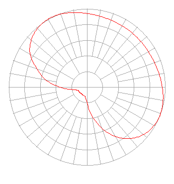 | |||||||||||||||||||||||
| Azimuth | Ratio | Azimuth | Ratio | Azimuth | Ratio | Azimuth | Ratio | |||||||||||||||||
| 0 | 0.939 | 10 | 0.919 | 20 | 0.907 | 30 | 0.901 | |||||||||||||||||
| 40 | 0.899 | 50 | 0.900 | 60 | 0.904 | 70 | 0.916 | |||||||||||||||||
| 80 | 0.935 | 90 | 0.961 | 100 | 0.986 | 110 | 0.999 | |||||||||||||||||
| 112 | 1.000 | 120 | 0.988 | 130 | 0.943 | 140 | 0.859 | |||||||||||||||||
| 150 | 0.733 | 160 | 0.561 | 170 | 0.377 | 180 | 0.200 | |||||||||||||||||
| 190 | 0.128 | 200 | 0.118 | 210 | 0.115 | 220 | 0.110 | |||||||||||||||||
| 230 | 0.115 | 240 | 0.118 | 250 | 0.124 | 260 | 0.185 | |||||||||||||||||
| 270 | 0.354 | 280 | 0.538 | 290 | 0.681 | 300 | 0.838 | |||||||||||||||||
| 310 | 0.929 | 320 | 0.981 | 330 | 0.998 | 332 | 1.000 | |||||||||||||||||
| 340 | 0.990 | 350 | 0.966 | |||||||||||||||||||||
Structure Registration Number 1222849 Structure Type: TOWER Registered To: SBA Properties, LLC Structure Address: 2680 Township Road 61 Minster, OH County Name: Auglaize County ASR Issued: 04/25/2013 Date Built: 05/09/2001 Site Elevation: 291.7 m (957 ft.) Structure Height: 91.4 m (300 ft.) Height Overall: 91.4 m (300 ft.) Overall Height AMSL: 383.1 m (1257 ft.) FAA Determination: 12/13/2001 FAA Study #: 01-AGL-7256-OE FAA Circular #: 70/7460-1K Paint & Light FAA Chapters: 4, 8, 12 PRIOR STUDY 00-AGL-8887-OE 40-23-19.2 N 84-21-26.4 W (NAD 83) 40-23-19.0 N 84-21-26.6 W (Converted to NAD 27) |
1424 Rice Avenue Lima, OH 45805 Phone: 419-228-8835 Corporation | Title: President And General Manager Date: 02/26/2020 Application Certifier West Central Ohio Broadcasting, Inc. 1424 Rice Avenue Lima, OH 45805 Applicant Christina H. Burrow Cooley Llp 1299 Pennsylvania Ave., Nw Suite 700 Washington, DC 20004 Legal Counsel Donald G. Everist Cohen, Dippell And Everist, P.c. 1420 N Street, Nw Suite One Washington, DC 20005 Technical Representative | ||||||||||||||||||||||