
FCCInfo.com
A Service of Cavell, Mertz & Associates, Inc.
(855) FCC-INFO
|
|
K31NI-D from 05/17/2011 K31NI-D from 09/10/2008 K31NI-D from 05/15/2008 |
|
|
||||||||||||||||
|
|
Status: License Application Accepted: 02/11/2020 License Expires: 04/01/2022 File Number: -0000105791 FCC Website Links: LMS Facility Details This Application Other K31NI-D Applications Including Superseded Applications Mailing Address Correspondence for K31NI-D Correspondence related to application -0000105791 Service Contour - Open Street Map or USGS Map (51 dBu) Service Contour - KML / Google Earth (51 dBu) Rabbit Ears Info Search for K31NI-D Site Location: 38-02-05.0 N 102-26-12.0 W (NAD 83) Site Location: 38-02-05.0 N 102-26-10.3 W (Converted to NAD 27) ERP: 0.205 kW Polarization: Horizontally polarized Electrical Beam Tilt: 1.75 degrees R/C AGL: 121 m (397 ft.) R/C AMSL: 1278.1 m (4193 ft.) Emission Mask: Stringent Site Elevation: 1157.1 m. (3796 ft.) Height Overall*: 123.1 m (404 ft.) (* As Filed In This Application, may differ from ASR Data, Below.) Directional Antenna - Antenna Make/Model: Electronics Research Inc. AL8OC-31-H Antenna ID: 1006401 Polarization: Horizontally polarized
| ||||||||||||||||||
| Antenna Data for Antenna Id: 1006401 K31NI-D LD File: -0000105791 Electronics Research Inc. - AL8OC-31-H Service: LD Standard Pattern: N | 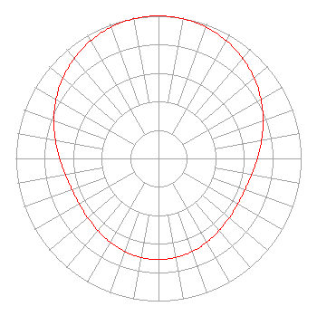 | ||||||||||||||||||
| Azimuth | Ratio | Azimuth | Ratio | Azimuth | Ratio | Azimuth | Ratio | ||||||||||||
| 0 | 1.000 | 10 | 0.995 | 20 | 0.979 | 30 | 0.953 | ||||||||||||
| 40 | 0.918 | 50 | 0.876 | 60 | 0.829 | 70 | 0.781 | ||||||||||||
| 80 | 0.734 | 90 | 0.694 | 100 | 0.663 | 110 | 0.645 | ||||||||||||
| 120 | 0.641 | 130 | 0.647 | 140 | 0.661 | 150 | 0.679 | ||||||||||||
| 160 | 0.694 | 170 | 0.705 | 180 | 0.709 | 190 | 0.705 | ||||||||||||
| 200 | 0.694 | 210 | 0.678 | 220 | 0.661 | 230 | 0.647 | ||||||||||||
| 240 | 0.641 | 250 | 0.645 | 260 | 0.663 | 270 | 0.694 | ||||||||||||
| 280 | 0.734 | 290 | 0.781 | 300 | 0.829 | 310 | 0.876 | ||||||||||||
| 320 | 0.918 | 330 | 0.953 | 340 | 0.979 | 350 | 0.995 | ||||||||||||
Structure Registration Number 1240181 Structure Type: TOWER Registered To: Prowers County Structure Address: 4mi Sw Of Carlton Carlton, CO County Name: Prowers County ASR Issued: 09/04/2003 Date Built: 10/12/1973 Site Elevation: 1157.1 m (3796 ft.) Structure Height: 123.1 m (404 ft.) Height Overall: 123.1 m (404 ft.) Overall Height AMSL: 1280.2 m (4200 ft.) FAA Determination: 10/12/1973 FAA Study #: 73-rm-263-oe Paint & Light FAA Chapters: 1, 3, 12, 21 RED LIGHTS/PAINT 38-02-05.0 N 102-26-12.0 W (NAD 83) 38-02-05.0 N 102-26-10.3 W (Converted to NAD 27) |
County Courthouse P. O. Box 1046 Lamar, CO 81052 Phone: 719-336-8025 Government Entity | Title: Board Chairman Date: 02/11/2020 Application Certifier PROWERS COUNTY Prowers County County Courthouse P. O. Box 1046 Lamar, CO 81052 Applicant Kyle Guild Thin Air Communications, Inc. 5357 Hwy 86 Unit 2 Elizabeth, CO 80107 Susan Hansen B. W. St. Clair 2305 Vida Shaw Rd. New Iberia, LA 70563 Consultant | |||||||||||||||||