
FCCInfo.com
A Service of Cavell, Mertz & Associates, Inc.
(855) FCC-INFO
|
|
|
Post-repack Channel 36 Virtual Channel 26 |
|
||||||||||||||||||||||||||||||||||||||||||||||
|
|
Repacking Information: Pre-Repack Channel: 45 Post-Repack Channel: 36 Post-Repack ERP: 42.1 kW Phase: 8 Completion Deadline: 3/13/2020 Find nearby TV Facilities Status: License Application Accepted: 03/23/2020 License Expires: 04/01/2023 File Number: -0000108722 FCC Website Links: LMS Facility Details This Application Other WMEA-TV Applications Including Superseded Applications Mailing Address Correspondence for WMEA-TV Correspondence related to application -0000108722 Service Contour - Open Street Map or USGS Map (41 dBu) Service Contour - KML / Google Earth (41 dBu) Public Inspection Files History Cards for WMEA-TV Rabbit Ears Info Search for WMEA-TV Site Location: 43-25-00.3 N 70-48-15.2 W (NAD 83) Site Location: 43-25-00.0 N 70-48-17.0 W (Converted to NAD 27) ERP: 149 kW Polarization: Horizontally polarized HAAT: 231 m (758 ft.) Electrical Beam Tilt: 0.75 degrees R/C AGL: 157.4 m (516 ft.) R/C AMSL: 349.4 m (1146 ft.) Site Elevation: 192 m. (630 ft.) Height Overall*: 163.3 m (536 ft.) (* As Filed In This Application, may differ from ASR Data, Below.) Directional Antenna - Antenna Make/Model: Dielectric TFU-18ETT-R S240 Antenna ID: 1002290 Polarization: Horizontally polarized | ||||||||||||||||||||||||||||||||||||||||||||||||
| Antenna Data for Antenna Id: 1002290 WMEA-TV DT File: -0000108722 Dielectric - TFU-18ETT-R S240 Service: DT Standard Pattern: N Pattern and Field Values Include a 90° Clockwise Rotation | 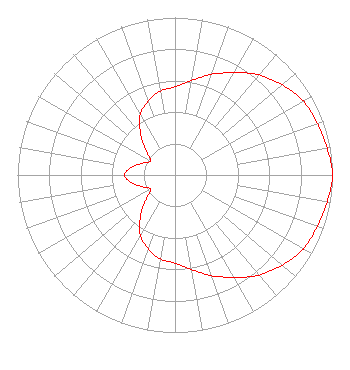 | ||||||||||||||||||||||||||||||||||||||||||||||||
| Azimuth | Ratio | Azimuth | Ratio | Azimuth | Ratio | Azimuth | Ratio | ||||||||||||||||||||||||||||||||||||||||||
| 0 | 0.560 | 10 | 0.610 | 20 | 0.680 | 30 | 0.750 | ||||||||||||||||||||||||||||||||||||||||||
| 40 | 0.830 | 50 | 0.890 | 60 | 0.940 | 70 | 0.960 | ||||||||||||||||||||||||||||||||||||||||||
| 80 | 0.980 | 90 | 1.000 | 100 | 0.980 | 110 | 0.960 | ||||||||||||||||||||||||||||||||||||||||||
| 120 | 0.940 | 130 | 0.890 | 140 | 0.830 | 150 | 0.750 | ||||||||||||||||||||||||||||||||||||||||||
| 160 | 0.680 | 170 | 0.610 | 180 | 0.560 | 190 | 0.540 | ||||||||||||||||||||||||||||||||||||||||||
| 200 | 0.500 | 210 | 0.440 | 220 | 0.340 | 230 | 0.240 | ||||||||||||||||||||||||||||||||||||||||||
| 240 | 0.180 | 250 | 0.220 | 260 | 0.280 | 270 | 0.320 | ||||||||||||||||||||||||||||||||||||||||||
| 280 | 0.280 | 290 | 0.220 | 300 | 0.180 | 310 | 0.240 | ||||||||||||||||||||||||||||||||||||||||||
| 320 | 0.340 | 330 | 0.440 | 340 | 0.500 | 350 | 0.540 | ||||||||||||||||||||||||||||||||||||||||||
Structure Registration Number 1037792 Structure Type: GTOWER Registered To: Maine Public Broadcasting Corp Structure Address: Mount Hope Rd Sanford, ME County Name: York County ASR Issued: 07/02/2019 Date Built: 04/24/2018 Site Elevation: 192 m (630 ft.) Structure Height: 152 m (499 ft.) Height Overall: 163.3 m (536 ft.) Overall Height AMSL: 355.3 m (1166 ft.) FAA Determination: 04/18/2018 FAA Study #: 2018-ANE-708-OE FAA Circular #: 70/7460-1L Paint & Light FAA Chapters: 3, 4, 5, 12 PRIOR STUDY 2002-ANE-811-OE 43-25-00.3 N 70-48-15.2 W (NAD 83) 43-25-00.0 N 70-48-17.0 W (Converted to NAD 27) |
1450 Lisbon Street Lewiston, ME 04240 Phone: 207-783-9101 Not-for-Profit | Title: Chief Technology Officer Date: 03/23/2020 Application Certifier MAINE PUBLIC BROADCASTING CORPORATION Maine Public Broadcasting Corporation 1450 Lisbon St Lewiston, ME 04240 Applicant Jeffrey F Mahaney Maine Public Broadcasting Corporation 63 Texas Avenue Bangor, ME 04401 CTO BARRY S. PERSH Gray Miller Persh Llp 2233 Wisconsin Avenue, Nw Suite 226 Washington, DC 20007 | |||||||||||||||||||||||||||||||||||||||||||||||
| |||||||||||||||||||||||||||||||||||||||||||||||||