
FCCInfo.com
A Service of Cavell, Mertz & Associates, Inc.
(855) FCC-INFO
|
|
WHWV-LD from 12/01/2000 WHWV-LD from 09/07/1999 WHWV-LD from 03/10/1999 |
|
|
|||||||||||||||||
|
|
Status: STA – Special Temporary Authority Application Accepted: 03/12/2020 STA Expires: 04/07/2020 File Number: -0000107826 FCC Website Links: LMS Facility Details This Application Other WHWV-LD Applications Including Superseded Applications Mailing Address Correspondence for WHWV-LD Correspondence related to application -0000107826 Service Contour - Open Street Map or USGS Map (74 dBu) Service Contour - KML / Google Earth (74 dBu) Rabbit Ears Info Search for WHWV-LD Site Location: 39-19-23.3 N 81-37-29.5 W (NAD 83) Site Location: 39-19-23.0 N 81-37-30.0 W (Converted to NAD 27) ERP: 16.5 kW Polarization: Horizontally polarized R/C AGL: 130 m (427 ft.) R/C AMSL: 384.8 m (1262 ft.) Site Elevation: 254.8 m. (836 ft.) Height Overall*: 153.6 m (504 ft.) (* As Filed In This Application, may differ from ASR Data, Below.) Directional Antenna - Antenna Make/Model: Andrew ALP16L2-HSER Antenna ID: 16524 Polarization: Horizontally polarized
| |||||||||||||||||||
| Antenna Data for Antenna Id: 16524 WHWV-LD TX File: -0000107826 Andrew - ALP16L2-HSER Service: TX Standard Pattern: Y Pattern and Field Values Include a 90° Clockwise Rotation | 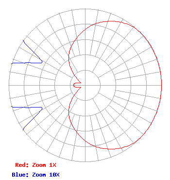 | |||||||||||||||||||
| Azimuth | Ratio | Azimuth | Ratio | Azimuth | Ratio | Azimuth | Ratio | |||||||||||||
| 0 | 0.725 | 10 | 0.815 | 20 | 0.886 | 30 | 0.946 | |||||||||||||
| 40 | 0.988 | 50 | 1.000 | 60 | 1.000 | 70 | 1.000 | |||||||||||||
| 80 | 1.000 | 90 | 1.000 | 100 | 1.000 | 110 | 1.000 | |||||||||||||
| 120 | 1.000 | 130 | 1.000 | 140 | 0.988 | 150 | 0.946 | |||||||||||||
| 160 | 0.886 | 170 | 0.815 | 180 | 0.725 | 190 | 0.624 | |||||||||||||
| 200 | 0.529 | 210 | 0.428 | 220 | 0.293 | 230 | 0.146 | |||||||||||||
| 240 | 0.067 | 250 | 0.085 | 260 | 0.136 | 270 | 0.147 | |||||||||||||
| 280 | 0.136 | 290 | 0.085 | 300 | 0.067 | 310 | 0.146 | |||||||||||||
| 320 | 0.293 | 330 | 0.428 | 340 | 0.529 | 350 | 0.624 | |||||||||||||
Structure Registration Number 1017216 Structure Type: GTOWER Registered To: iHeartMedia Entertainment, Inc. Structure Address: .25 Mi Wnw From Way Rd To Farson St Belpre, OH County Name: Washington County ASR Issued: 08/29/2017 Date Built: 10/01/1988 Site Elevation: 254.8 m (836 ft.) Structure Height: 153.6 m (504 ft.) Height Overall: 153.6 m (504 ft.) Overall Height AMSL: 408.4 m (1340 ft.) FAA Determination: 04/29/2015 FAA Study #: 2015-AGL-4098-OE FAA Circular #: 70/7460-1J Paint & Light FAA Chapters: 3, 4, 5, 13 PRIOR STUDY 1997-AGL-3585-OE 39-19-23.3 N 81-37-29.5 W (NAD 83) 39-19-23.0 N 81-37-30.0 W (Converted to NAD 27) |
Po Box 11409 Chattanooga, TN 37401 Phone: 423-468-5100 Limited Liability Company | Title: Coo Date: 03/12/2020 Application Certifier DIGITAL NETWORKS-NORTHEAST, LLC Digital Networks-northeast, Llc Po Box 11409 Chattanooga, TN 37401 Applicant Timothy K Hurley Digital Networks, Llc Chattanooga, TN 37401 Engineer Jeremy D Ruck, PE Jeremy Ruck & Associates, Inc. Canton, IL 61520 Consulting Engineer Aaron P Shainis Shainis & Peltzman, Chartered 1850 M St. Nw Suite 240 Washington, DC 20036 FCC Legal Counsel | ||||||||||||||||||