
FCCInfo.com
A Service of Cavell, Mertz & Associates, Inc.
(855) FCC-INFO
|
|
DWMNE-LP from 05/04/2012 DWMNE-LP from 08/05/1999 DWMNE-LP from 08/28/1990 |
|
|
||||||||||||||||
|
|
Status: STA – Special Temporary Authority Application Accepted: 03/12/2020 STA Expires: 04/03/2020 File Number: -0000107832 FCC Website Links: LMS Facility Details This Application Other DWMNE-LP Applications Including Superseded Applications Mailing Address Correspondence for DWMNE-LP Correspondence related to application -0000107832 Service Contour - Open Street Map or USGS Map (74 dBu) Service Contour - KML / Google Earth (74 dBu) Rabbit Ears Info Search for DWMNE-LP Site Location: 43-44-38.3 N 70-19-59.0 W (NAD 83) Site Location: 43-44-38.0 N 70-20-00.8 W (Converted to NAD 27) ERP: 25 kW R/C AGL: 122 m (400 ft.) R/C AMSL: 248.4 m (815 ft.) Site Elevation: 126.4 m. (415 ft.) Height Overall*: 139.9 m (459 ft.) (* As Filed In This Application, may differ from ASR Data, Below.) Directional Antenna - Antenna Make/Model: Andrew ALP24L3-HSW Antenna ID: 16711 | ||||||||||||||||||
| Antenna Data for Antenna Id: 16711 DWMNE-LP TX File: -0000107832 Andrew - ALP24L3-HSW Service: TX Standard Pattern: Y Pattern and Field Values Include a 130° Clockwise Rotation | 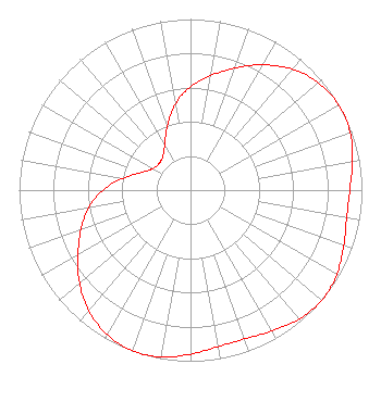 | ||||||||||||||||||
| Azimuth | Ratio | Azimuth | Ratio | Azimuth | Ratio | Azimuth | Ratio | ||||||||||||
| 0 | 0.605 | 10 | 0.680 | 20 | 0.758 | 30 | 0.845 | ||||||||||||
| 40 | 0.922 | 50 | 0.975 | 60 | 0.997 | 70 | 0.990 | ||||||||||||
| 80 | 0.959 | 90 | 0.929 | 100 | 0.925 | 110 | 0.951 | ||||||||||||
| 120 | 0.985 | 130 | 1.000 | 140 | 0.985 | 150 | 0.951 | ||||||||||||
| 160 | 0.925 | 170 | 0.929 | 180 | 0.959 | 190 | 0.990 | ||||||||||||
| 200 | 0.997 | 210 | 0.975 | 220 | 0.922 | 230 | 0.845 | ||||||||||||
| 240 | 0.758 | 250 | 0.680 | 260 | 0.605 | 270 | 0.510 | ||||||||||||
| 280 | 0.397 | 290 | 0.302 | 300 | 0.253 | 310 | 0.241 | ||||||||||||
| 320 | 0.253 | 330 | 0.302 | 340 | 0.397 | 350 | 0.510 | ||||||||||||
Structure Registration Number 1018653 Structure Type: TOWER Registered To: TOWER SPECIALISTS INC Structure Address: 115 Hardy Rd Falmouth, ME County Name: Cumberland County ASR Issued: 09/11/2009 Date Built: 09/11/2009 Site Elevation: 126.4 m (415 ft.) Structure Height: 128 m (420 ft.) Height Overall: 139.9 m (459 ft.) Overall Height AMSL: 266.3 m (874 ft.) FAA Determination: 09/03/2009 FAA Study #: 2009-ANE-752-OE FAA Circular #: 70/7460-1K Paint & Light FAA Chapters: 3, 4, 5, 12 PRIOR STUDY 2006-ANE-486-OE 43-44-38.3 N 70-19-59.0 W (NAD 83) 43-44-38.0 N 70-20-00.8 W (Converted to NAD 27) |
Chattanooga, TN 37401 Phone: 423-468-5100 Limited Liability Company | Title: Coo Date: 03/12/2020 Application Certifier DIGITAL NETWORKS-NORTHEAST, LLC Digital Networks-northeast, Llc Po Box 11409 Chattanooga, TN 37401 Applicant Timothy K Hurley Digital Networks Llc Chattanooga, TN 37401 Engineer Jeremy D Ruck, PE Jeremy Ruck & Associates, Inc. Canton, IL 61520 Consulting Engineer Aaron P Shainis, Esq Shainis & Peltzman, Chartered 1850 M Street Nw Suite 240 Washington, DC 20036 Attorney | |||||||||||||||||