
FCCInfo.com
A Service of Cavell, Mertz & Associates, Inc.
(855) FCC-INFO
|
|
WPYM-LD from 01/23/2013 WPYM-LD from 02/04/2002 |
|
|
||||||||||||||||
|
|
Status: STA – Special Temporary Authority Application Accepted: 03/13/2020 STA Expires: 04/03/2020 File Number: -0000107904 FCC Website Links: LMS Facility Details This Application Other WPYM-LD Applications Including Superseded Applications Mailing Address Correspondence for WPYM-LD Correspondence related to application -0000107904 Service Contour - Open Street Map or USGS Map (51 dBu) Service Contour - KML / Google Earth (51 dBu) Rabbit Ears Info Search for WPYM-LD Site Location: 34-32-46.5 N 90-37-16.2 W (NAD 83) Site Location: 34-32-46.1 N 90-37-15.8 W (Converted to NAD 27) ERP: 12 kW Polarization: Horizontally polarized R/C AGL: 80 m (262 ft.) R/C AMSL: 184.8 m (606 ft.) Emission Mask: Full Service Site Elevation: 104.8 m. (344 ft.) Height Overall*: 87.7 m (288 ft.) (* As Filed In This Application, may differ from ASR Data, Below.) Directional Antenna - Antenna Make/Model: Scala PR-450CU Antenna ID: 23500 Polarization: Horizontally polarized | ||||||||||||||||||
| Antenna Data for Antenna Id: 23500 WPYM-LD LD File: -0000107904 Scala - PR-450CU Service: LD Standard Pattern: Y Pattern and Field Values Include a 45° Clockwise Rotation | 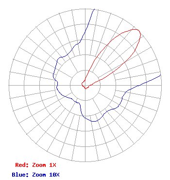 | ||||||||||||||||||
| Azimuth | Ratio | Azimuth | Ratio | Azimuth | Ratio | Azimuth | Ratio | ||||||||||||
| 5 | 0.090 | 15 | 0.180 | 25 | 0.460 | 35 | 0.815 | ||||||||||||
| 45 | 1.000 | 55 | 0.800 | 65 | 0.400 | 75 | 0.150 | ||||||||||||
| 85 | 0.090 | 95 | 0.060 | 105 | 0.052 | 115 | 0.052 | ||||||||||||
| 125 | 0.051 | 135 | 0.046 | 145 | 0.045 | 155 | 0.048 | ||||||||||||
| 165 | 0.049 | 175 | 0.045 | 185 | 0.039 | 195 | 0.026 | ||||||||||||
| 205 | 0.025 | 215 | 0.025 | 225 | 0.025 | 235 | 0.028 | ||||||||||||
| 245 | 0.032 | 255 | 0.035 | 265 | 0.037 | 275 | 0.036 | ||||||||||||
| 285 | 0.043 | 295 | 0.044 | 305 | 0.046 | 315 | 0.049 | ||||||||||||
| 325 | 0.046 | 335 | 0.047 | 345 | 0.053 | 355 | 0.059 | ||||||||||||
Structure Registration Number 1029696 Structure Type: LTOWER Registered To: American Towers LLC Structure Address: Approx 100 Yds W Of Campus Drive On T&i Bldg Drive West Helena, AR County Name: Phillips County ASR Issued: 12/09/2016 Date Built: 11/13/2002 Site Elevation: 104.8 m (344 ft.) Structure Height: 85.3 m (280 ft.) Height Overall: 87.7 m (288 ft.) Overall Height AMSL: 192.5 m (632 ft.) FAA Determination: 06/04/2015 FAA Study #: 2015-ASW-1326-OE Paint & Light FAA Chapters: A1, H, 3, 11, 21, 23 Continue As Is OM&L = A MED-DUAL SYSTEM 34-32-46.5 N 90-37-16.2 W (NAD 83) 34-32-46.1 N 90-37-15.8 W (Converted to NAD 27) |
Chattanooga, TN 37401 Phone: 423-468-5100 Limited Liability Company | Title: Coo Date: 03/13/2020 Application Certifier DIGITAL NETWORKS-SOUTHEAST, LLC Digital Networks-southeast, Llc P.o. Box 11409 Chattanooga, TN 37401 Applicant Timothy K Hurley Digital Networks, Llc Chattanooga, TN 37401 Engineer Jeremy D Ruck, PE Jeremy Ruck & Associates, Inc. Canton, IL 61520 Consulting Engineer Aaron P Shainis, Esq Shainis & Peltzman, Chartered 1850 M Street Nw Suite 240 Washington, DC 20036 Attorney | |||||||||||||||||