
FCCInfo.com
A Service of Cavell, Mertz & Associates, Inc.
(855) FCC-INFO
|
|
WRBU from 07/25/1989 WRBU from 06/01/1989 WRBU from 08/13/1987 |
Post-repack Channel 28 Virtual Channel 46 |  |
|
||||||||||||||||||
|
|
Repacking Information: Pre-Repack Channel: 47 Post-Repack Channel: 28 Post-Repack ERP: 75.3 kW Phase: 8 Completion Deadline: 3/13/2020 Find nearby TV Facilities Status: License Application Accepted: 03/23/2020 License Expires: 12/01/2021 File Number: -0000108757 FCC Website Links: LMS Facility Details This Application Other WRBU Applications Including Superseded Applications Mailing Address Correspondence for WRBU Correspondence related to application -0000108757 Service Contour - Open Street Map or USGS Map (41 dBu) Service Contour - KML / Google Earth (41 dBu) Public Inspection Files Rabbit Ears Info Search for WRBU Site Location: 38-23-18.0 N 90-29-16.0 W (NAD 83) Site Location: 38-23-17.8 N 90-29-15.6 W (Converted to NAD 27) ERP: 1000 kW Polarization: Elliptically polarized HAAT: 334 m (1096 ft.) Electrical Beam Tilt: 0.75 degrees R/C AGL: 250 m (820 ft.) R/C AMSL: 515 m (1690 ft.) Site Elevation: 265 m. (869 ft.) Height Overall*: 259 m (850 ft.) (* As Filed In This Application, may differ from ASR Data, Below.) Directional Antenna - Antenna Make/Model: Electronics Research Inc. ATW26H3-ETSX-28H Antenna ID: 1006585 Polarization: Elliptically polarized | |||||||||||||||||||||
| Antenna Data for Antenna Id: 1006585 WRBU DT File: -0000108757 Electronics Research Inc. - ATW26H3-ETSX-28H Service: DT Standard Pattern: N | 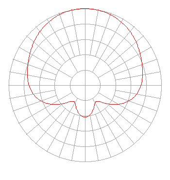 | |||||||||||||||||||||
| Azimuth | Ratio | Azimuth | Ratio | Azimuth | Ratio | Azimuth | Ratio | |||||||||||||||
| 0 | 1.000 | 10 | 0.994 | 20 | 0.978 | 30 | 0.950 | |||||||||||||||
| 40 | 0.914 | 50 | 0.872 | 60 | 0.830 | 70 | 0.794 | |||||||||||||||
| 80 | 0.765 | 90 | 0.733 | 100 | 0.685 | 110 | 0.608 | |||||||||||||||
| 120 | 0.500 | 130 | 0.376 | 140 | 0.276 | 150 | 0.264 | |||||||||||||||
| 160 | 0.327 | 170 | 0.392 | 180 | 0.417 | 190 | 0.392 | |||||||||||||||
| 200 | 0.327 | 210 | 0.264 | 220 | 0.276 | 230 | 0.376 | |||||||||||||||
| 240 | 0.500 | 250 | 0.608 | 260 | 0.685 | 270 | 0.733 | |||||||||||||||
| 280 | 0.765 | 290 | 0.794 | 300 | 0.830 | 310 | 0.872 | |||||||||||||||
| 320 | 0.914 | 330 | 0.950 | 340 | 0.978 | 350 | 0.994 | |||||||||||||||
Structure Registration Number 1003634 Structure Type: TOWER Registered To: EIP Communications I, LLC Structure Address: 4200 Dry Fork Rd Imperial, MO County Name: Jefferson County ASR Issued: 11/30/2023 Date Built: 09/23/1989 Site Elevation: 265 m (869 ft.) Structure Height: 245 m (804 ft.) Height Overall: 259 m (850 ft.) Overall Height AMSL: 524 m (1719 ft.) FAA Determination: 10/14/1987 FAA Study #: 87-ACE-0419-OE FAA Circular #: 70/7460-1G Paint & Light FAA Chapters: 3, 4, 5, 9 38-23-18.0 N 90-29-16.0 W (NAD 83) 38-23-17.8 N 90-29-15.6 W (Converted to NAD 27) |
312 Walnut Street 28th Floor Cincinnati, OH 45202 Phone: 513-977-3000 Limited Liability Company | Title: Vp Date: 03/23/2020 Application Certifier ION MEDIA LICENSE COMPANY, LLC Ion Media License Company, Llc 601 Clearwater Park Road West Palm Beach, FL 33401 Applicant Shea Clark Ion Media Networks, Inc. 14444 66th Street North Clearwater, FL 33764 VP, Engineering Bianca Frye Ion Media Networks, Inc. 601 Clearwater Park Road West Palm Beach, FL 33401 | ||||||||||||||||||||
| ||||||||||||||||||||||