
FCCInfo.com
A Service of Cavell, Mertz & Associates, Inc.
(855) FCC-INFO
|
|
|
Post-repack Channel 34 Virtual Channel 29 |
|
||||||||||||||||
|
|
Repacking Information: Pre-Repack Channel: 29 Post-Repack Channel: 34 Post-Repack ERP: 1000 kW Phase: 5 Completion Deadline: 9/11/2019 Upstream/Downstream Dependencies Other Linked Stations Find nearby TV Facilities Status: License Application Accepted: 03/31/2020 License Expires: 04/01/2021 File Number: -0000110807 FCC Website Links: LMS Facility Details This Application Other WBIH Applications Including Superseded Applications Mailing Address Correspondence for WBIH Correspondence related to application -0000110807 Service Contour - Open Street Map or USGS Map (41 dBu) Service Contour - KML / Google Earth (41 dBu) Public Inspection Files Rabbit Ears Info Search for WBIH Site Location: 32-32-26.7 N 86-50-32.7 W (NAD 83) Site Location: 32-32-26.2 N 86-50-32.8 W (Converted to NAD 27) ERP: 1000 kW Polarization: Horizontally polarized HAAT: 403.5 m (1324 ft.) Electrical Beam Tilt: 0.75 degrees R/C AGL: 358.6 m (1177 ft.) R/C AMSL: 501.2 m (1644 ft.) Site Elevation: 142.6 m. (468 ft.) Height Overall*: 367.9 m (1207 ft.) (* As Filed In This Application, may differ from ASR Data, Below.) Directional Antenna - Antenna Make/Model: DIELECTRIC TFU-29ETT-R S360 Antenna ID: 1006624 Polarization: Horizontally polarized | ||||||||||||||||||
| Antenna Data for Antenna Id: 1006624 WBIH DT File: -0000110807 DIELECTRIC - TFU-29ETT-R S360 Service: DT Standard Pattern: N | 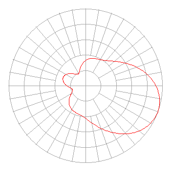 | ||||||||||||||||||
| Azimuth | Ratio | Azimuth | Ratio | Azimuth | Ratio | Azimuth | Ratio | ||||||||||||
| 0 | 0.326 | 10 | 0.356 | 20 | 0.372 | 30 | 0.388 | ||||||||||||
| 40 | 0.424 | 50 | 0.492 | 60 | 0.589 | 70 | 0.703 | ||||||||||||
| 80 | 0.817 | 90 | 0.913 | 100 | 0.977 | 110 | 1.000 | ||||||||||||
| 120 | 0.977 | 130 | 0.913 | 140 | 0.817 | 150 | 0.703 | ||||||||||||
| 160 | 0.589 | 170 | 0.492 | 180 | 0.424 | 190 | 0.388 | ||||||||||||
| 200 | 0.372 | 210 | 0.356 | 220 | 0.326 | 230 | 0.277 | ||||||||||||
| 240 | 0.217 | 250 | 0.178 | 260 | 0.193 | 270 | 0.245 | ||||||||||||
| 280 | 0.291 | 290 | 0.309 | 300 | 0.291 | 310 | 0.245 | ||||||||||||
| 320 | 0.193 | 330 | 0.178 | 340 | 0.217 | 350 | 0.277 | ||||||||||||
Structure Registration Number 1210735 Structure Type: Registered To: RADIANT LIFE MINISTRIES, INC. Structure Address: 1/4 Mile West Of Bonita Bonita, AL County Name: Autauga County ASR Issued: 06/10/2021 Date Built: 03/31/2020 Site Elevation: 142.6 m (468 ft.) Structure Height: 347.5 m (1140 ft.) Height Overall: 367.9 m (1207 ft.) Overall Height AMSL: 510.5 m (1675 ft.) FAA Determination: 10/26/2001 FAA Study #: 01-ASO-8117-OE Paint & Light FAA Chapters: A1, B, E, H, 3, 8, 17, 21, 23 PRIOR STUDY 99-ASO-3398-OE. OM&L TO REMAIN A HI-DUAL SYSTEM. 32-32-26.7 N 86-50-32.7 W (NAD 83) 32-32-26.2 N 86-50-32.8 W (Converted to NAD 27) |
Po Box 1010 Marion, IL 62959 Phone: 618-997-4700 Not-for-Profit | Title: President Date: 03/31/2020 Application Certifier Flinn Broadcasting Corporation 6080 Mt. Moriah Ext. Memphis, TN 38115 Applicant William Jeffrey Reynolds Du Treil, Lundin & Rackley, Inc. 3135 Southgate Circle Sarasota, FL 34239 Technical Consultant Stephen C Simpson Attorney At Law 1250 Connecticut Avenue, Nw Suite 700 Washington, DC 20036 Attorney at Law | |||||||||||||||||