
FCCInfo.com
A Service of Cavell, Mertz & Associates, Inc.
(855) FCC-INFO
|
|
WNVC from 12/22/1981 |
RF spectrum relinquished in the spectrum auction Virtual Channel 30 |
|
|||||||||||||||||||
|
|
WNVC is a channel sharing guest of WHTJ, Charlottesville, Virginia Repacking Information: Channel 24 was relinquished in the spectrum auction Status: License Application Accepted: 04/21/2020 License Expires: 10/01/2020 File Number: -0000112472 FCC Website Links: LMS Facility Details This Application Other WNVC Applications Including Superseded Applications Mailing Address Correspondence for WNVC Correspondence related to application -0000112472 Service Contour - Open Street Map or USGS Map (41 dBu) Service Contour - KML / Google Earth (41 dBu) Public Inspection Files History Cards for WNVC Rabbit Ears Info Search for WNVC Site Location: 37-59-00.0 N 78-29-01.0 W (NAD 83) Site Location: 37-58-59.5 N 78-29-02.0 W (Converted to NAD 27) ERP: 300 kW Polarization: Horizontally polarized HAAT: 335.0 m (1099 ft.) Electrical Beam Tilt: 1.0 degree R/C AGL: 72 m (236 ft.) R/C AMSL: 499.1 m (1637 ft.) Site Elevation: 427.1 m. (1401 ft.) Height Overall*: 90.5 m (297 ft.) (* As Filed In This Application, may differ from ASR Data, Below.) Directional Antenna - Antenna Make/Model: DIELECTRIC TFU-16DSB-B(C) Antenna ID: 70070 Polarization: Horizontally polarized | |||||||||||||||||||||
| Antenna Data for Antenna Id: 70070 WNVC DT File: -0000112472 DIELECTRIC - TFU-16DSB-B(C) Service: DT Standard Pattern: Y Pattern and Field Values Include a 337° Clockwise Rotation | 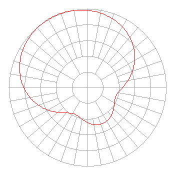 | |||||||||||||||||||||
| Azimuth | Ratio | Azimuth | Ratio | Azimuth | Ratio | Azimuth | Ratio | |||||||||||||||
| 7 | 0.967 | 17 | 0.939 | 27 | 0.901 | 37 | 0.851 | |||||||||||||||
| 47 | 0.790 | 57 | 0.717 | 67 | 0.634 | 77 | 0.548 | |||||||||||||||
| 87 | 0.467 | 97 | 0.405 | 107 | 0.377 | 117 | 0.386 | |||||||||||||||
| 127 | 0.419 | 137 | 0.457 | 147 | 0.485 | 157 | 0.496 | |||||||||||||||
| 167 | 0.485 | 177 | 0.457 | 187 | 0.419 | 197 | 0.386 | |||||||||||||||
| 207 | 0.377 | 217 | 0.405 | 227 | 0.467 | 237 | 0.548 | |||||||||||||||
| 247 | 0.634 | 257 | 0.717 | 267 | 0.790 | 277 | 0.851 | |||||||||||||||
| 287 | 0.901 | 297 | 0.939 | 307 | 0.967 | 317 | 0.985 | |||||||||||||||
| 327 | 0.996 | 337 | 1.000 | 347 | 0.996 | 357 | 0.985 | |||||||||||||||
Structure Registration Number 1018222 Structure Type: GTOWER Registered To: VPM Media Corporation Structure Address: Carters Mountain 3.1 Mi S Charlottesville, VA County Name: Albemarle County ASR Issued: 06/18/2020 Date Built: 06/15/2019 Site Elevation: 427.1 m (1401 ft.) Structure Height: 81.7 m (268 ft.) Height Overall: 90.5 m (297 ft.) Overall Height AMSL: 517.6 m (1698 ft.) FAA Determination: 05/06/2019 FAA Study #: 2019-AEA-5099-OE FAA Circular #: 70/7460-1L Paint & Light FAA Chapters: 4, 8, 12 PRIOR STUDY 1997-AEA-898-OE 37-59-00.0 N 78-29-01.0 W (NAD 83) 37-58-59.5 N 78-29-02.0 W (Converted to NAD 27) |
23 Sesame Street Richmond, VA 23235 Phone: 804-320-1301 Not-for-Profit | Application Certifier Commonwealth Public Broadcasting Corporation 23 Sesame Street Richmond, VA 23235 Applicant Ari Meltzer Wiley Rein Llp 1776 K Street Nw Washington, DC 20006 | ||||||||||||||||||||
| ||||||||||||||||||||||