
FCCInfo.com
A Service of Cavell, Mertz & Associates, Inc.
(855) FCC-INFO
|
|
KFDY-LD from 09/19/2011 KFDY-LD from 11/25/2002 KFDY-LD from 11/09/1992 |
|
|
||||||||||||||||
|
|
Status: License Application Accepted: 05/14/2020 License Expires: 06/01/2022 File Number: -0000113709 FCC Website Links: LMS Facility Details This Application Other KFDY-LD Applications Including Superseded Applications Mailing Address Correspondence for KFDY-LD Correspondence related to application -0000113709 Service Contour - Open Street Map or USGS Map (51 dBu) Service Contour - KML / Google Earth (51 dBu) Rabbit Ears Info Search for KFDY-LD Site Location: 40-43-39.7 N 96-36-50.9 W (NAD 83) Site Location: 40-43-39.7 N 96-36-49.8 W (Converted to NAD 27) ERP: 3.65 kW Polarization: Horizontally polarized R/C AGL: 140.8 m (462 ft.) R/C AMSL: 566.9 m (1860 ft.) Emission Mask: Full Service Site Elevation: 426.1 m. (1398 ft.) Height Overall*: 194.8 m (639 ft.) (* As Filed In This Application, may differ from ASR Data, Below.) Directional Antenna - Antenna Make/Model: BELCO BAN-4000 CUSTOM Antenna ID: 1004116 Polarization: Horizontally polarized | ||||||||||||||||||
| Antenna Data for Antenna Id: 1004116 KFDY-LD LD File: -0000113709 BELCO - BAN-4000 CUSTOM Service: LD Standard Pattern: Y | 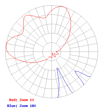 | ||||||||||||||||||
| Azimuth | Ratio | Azimuth | Ratio | Azimuth | Ratio | Azimuth | Ratio | ||||||||||||
| 0 | 0.886 | 10 | 0.988 | 14 | 1.000 | 20 | 0.961 | ||||||||||||
| 30 | 0.813 | 40 | 0.636 | 50 | 0.476 | 60 | 0.338 | ||||||||||||
| 70 | 0.241 | 80 | 0.169 | 90 | 0.103 | 100 | 0.123 | ||||||||||||
| 110 | 0.160 | 120 | 0.120 | 130 | 0.066 | 140 | 0.134 | ||||||||||||
| 150 | 0.129 | 160 | 0.038 | 170 | 0.090 | 180 | 0.134 | ||||||||||||
| 190 | 0.127 | 200 | 0.110 | 210 | 0.186 | 220 | 0.247 | ||||||||||||
| 230 | 0.342 | 240 | 0.474 | 250 | 0.629 | 260 | 0.808 | ||||||||||||
| 270 | 0.952 | 280 | 0.981 | 290 | 0.890 | 300 | 0.748 | ||||||||||||
| 310 | 0.787 | 320 | 0.923 | 325 | 0.948 | 330 | 0.888 | ||||||||||||
| 340 | 0.786 | 350 | 0.742 | ||||||||||||||||
Structure Registration Number 1219481 Structure Type: GTOWER Registered To: Warner LLC Structure Address: 7900 Yankee Hill Road Lincoln, NE County Name: Lancaster County ASR Issued: 01/10/2020 Date Built: 01/24/2001 Site Elevation: 426.1 m (1398 ft.) Structure Height: 194.8 m (639 ft.) Height Overall: 194.8 m (639 ft.) Overall Height AMSL: 620.9 m (2037 ft.) FAA Determination: 10/24/2000 FAA Study #: 00-ACE-0930-OE FAA Circular #: 70/7460-1K Paint & Light FAA Chapters: 3, 4, 5, 12 PRIOR FAA 00-ACE-0381-OE 40-43-39.7 N 96-36-50.9 W (NAD 83) 40-43-39.7 N 96-36-49.8 W (Converted to NAD 27) |
214 N. 17th Street Suite 1 Norfolk, NE 68702 Phone: 420-371-0100 Limited Liability Company | Title: Managing Member Date: 05/14/2020 Application Certifier FLOOD COMMUNICATIONS OF OMAHA, LLC Flood Communications Of Omaha, Llc 214 N. 17th Street Norfolk, NE 68702 Applicant Clarence M Beverage Communications Technologies, Inc. Marlton, NJ 08055 Broadcast Engineering Consultant Matthew H McCormick, Esq Fletcher, Heald & Hildreth, Plc 1300 N 17th Street, Suite 1100 Arlington, VA 22209 | |||||||||||||||||