
FCCInfo.com
A Service of Cavell, Mertz & Associates, Inc.
(855) FCC-INFO
|
|
WNIB-LD from 06/03/2019 WNIB-LD from 09/21/2018 WNIB-LD from 06/01/2018 WNIB-LD from 05/31/2018 WNIB-LD from 02/08/2017 WNIB-LD from 10/29/2016 WNIB-LD from 02/08/2016 WNIB-LD from 09/11/2009 WNIB-LD from 08/01/2002 WNIB-LD from 02/09/1990 |
|
|
||||||||||||||||
|
|
Status: License Application Accepted: 06/17/2020 License Expires: 06/01/2023 File Number: -0000116280 FCC Website Links: LMS Facility Details This Application Other WNIB-LD Applications Including Superseded Applications Mailing Address Correspondence for WNIB-LD Correspondence related to application -0000116280 Service Contour - Open Street Map or USGS Map (48 dBu) Service Contour - KML / Google Earth (48 dBu) Rabbit Ears Info Search for WNIB-LD Site Location: 43-15-47.3 N 77-39-34.7 W (NAD 83) Site Location: 43-15-47.1 N 77-39-35.7 W (Converted to NAD 27) ERP: 3 kW Polarization: Horizontally polarized R/C AGL: 81.2 m (266 ft.) R/C AMSL: 159.8 m (524 ft.) Emission Mask: Full Service Site Elevation: 78.6 m. (258 ft.) Height Overall*: 92.4 m (303 ft.) (* As Filed In This Application, may differ from ASR Data, Below.) Directional Antenna - Antenna Make/Model: Kathrein-Scala 2x2 K5234517 Antenna ID: 1005243 Polarization: Horizontally polarized | ||||||||||||||||||
| Antenna Data for Antenna Id: 1005243 WNIB-LD LD File: -0000116280 Kathrein-Scala - 2x2 K5234517 Service: LD Standard Pattern: N | 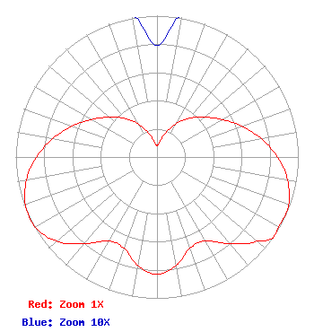 | ||||||||||||||||||
| Azimuth | Ratio | Azimuth | Ratio | Azimuth | Ratio | Azimuth | Ratio | ||||||||||||
| 0 | 0.079 | 10 | 0.109 | 20 | 0.186 | 30 | 0.276 | ||||||||||||
| 40 | 0.358 | 50 | 0.439 | 60 | 0.532 | 70 | 0.638 | ||||||||||||
| 80 | 0.749 | 90 | 0.853 | 100 | 0.938 | 110 | 0.991 | ||||||||||||
| 120 | 0.993 | 125 | 1.000 | 130 | 0.928 | 140 | 0.801 | ||||||||||||
| 150 | 0.685 | 160 | 0.686 | 170 | 0.779 | 180 | 0.830 | ||||||||||||
| 190 | 0.779 | 200 | 0.686 | 210 | 0.685 | 220 | 0.801 | ||||||||||||
| 230 | 0.928 | 240 | 0.993 | 250 | 0.991 | 260 | 0.938 | ||||||||||||
| 270 | 0.853 | 280 | 0.749 | 290 | 0.638 | 300 | 0.532 | ||||||||||||
| 310 | 0.439 | 320 | 0.358 | 330 | 0.276 | 340 | 0.186 | ||||||||||||
| 350 | 0.109 | ||||||||||||||||||
Structure Registration Number 1006267 Structure Type: TOWER Registered To: Crown Atlantic Company LLC Structure Address: 400 Island Cottage Rd Greece, NY County Name: Monroe County ASR Issued: 05/06/2016 Date Built: 08/06/2000 Site Elevation: 78.6 m (258 ft.) Structure Height: 87.4 m (287 ft.) Height Overall: 92.4 m (303 ft.) Overall Height AMSL: 171 m (561 ft.) FAA Determination: 06/29/2010 FAA Study #: 2010-AEA-1662-OE FAA Circular #: 70/7460-1K Paint & Light FAA Chapters: 4, 8, 12 OM&L to remain the same as prior study = A MED-DUAL SYSTEM 43-15-47.3 N 77-39-34.7 W (NAD 83) 43-15-47.1 N 77-39-35.7 W (Converted to NAD 27) |
Marion, IL 62959 Phone: 618-997-4700 Not-for-Profit | Title: President Date: 06/17/2020 Application Certifier Tri-state Christian Tv, Inc. P. O. Box 1010 Marion, IL 62959 Applicant Kevin T Fisher Smith And Fisher, Llc 4791 Wintergreen Court Woodbridge, VA 22192 Engineering Consultant Colby M May, ESQ. Colby M. May, Esq., P.c. Washington, DC 20003 Legal Counsel | |||||||||||||||||