
FCCInfo.com
A Service of Cavell, Mertz & Associates, Inc.
(855) FCC-INFO
|
|
KSJF-CD from 08/27/2004 KSJF-CD from 04/29/1999 KSJF-CD from 03/11/1991 KSJF-CD from 07/31/1989 |
Post-repack Channel 34 |
|
||||||||||||||||
|
|
Repacking Information: Pre-Repack Channel: 50 Post-Repack Channel: 34 Post-Repack ERP: 0.936 kW Phase: 2 Completion Deadline: 4/12/2019 Find nearby TV Facilities Status: License Application Accepted: 06/25/2020 License Expires: 06/01/2022 File Number: -0000116533 FCC Website Links: LMS Facility Details This Application Other KSJF-CD Applications Including Superseded Applications Mailing Address Correspondence for KSJF-CD Correspondence related to application -0000116533 Service Contour - Open Street Map or USGS Map (51 dBu) Service Contour - KML / Google Earth (51 dBu) Public Inspection Files Rabbit Ears Info Search for KSJF-CD Site Location: 35-31-30.2 N 94-22-28.2 W (NAD 83) Site Location: 35-31-29.9 N 94-22-27.4 W (Converted to NAD 27) ERP: 14 kW Polarization: Horizontally polarized Electrical Beam Tilt: 0.50 degrees R/C AGL: 30 m (98 ft.) R/C AMSL: 365.6 m (1199 ft.) Emission Mask: Full Service Site Elevation: 335.6 m. (1101 ft.) Height Overall*: 48.8 m (160 ft.) (* As Filed In This Application, may differ from ASR Data, Below.) Directional Antenna - Antenna Make/Model: Propagation System Inc PSILP12BA-34 Antenna ID: 1006971 Polarization: Horizontally polarized | ||||||||||||||||||
| Antenna Data for Antenna Id: 1006971 KSJF-CD DC File: -0000116533 Propagation System Inc - PSILP12BA-34 Service: DC Standard Pattern: N | 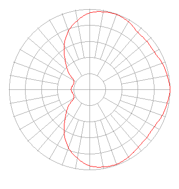 | ||||||||||||||||||
| Azimuth | Ratio | Azimuth | Ratio | Azimuth | Ratio | Azimuth | Ratio | ||||||||||||
| 0 | 0.949 | 10 | 0.979 | 20 | 0.989 | 30 | 0.969 | ||||||||||||
| 40 | 0.929 | 50 | 0.929 | 60 | 0.929 | 70 | 0.959 | ||||||||||||
| 80 | 0.979 | 90 | 1.000 | 100 | 0.979 | 110 | 0.959 | ||||||||||||
| 120 | 0.929 | 130 | 0.929 | 140 | 0.939 | 150 | 0.969 | ||||||||||||
| 160 | 0.989 | 170 | 0.979 | 180 | 0.949 | 190 | 0.869 | ||||||||||||
| 200 | 0.769 | 210 | 0.629 | 220 | 0.469 | 230 | 0.349 | ||||||||||||
| 240 | 0.229 | 250 | 0.209 | 260 | 0.219 | 270 | 0.229 | ||||||||||||
| 280 | 0.219 | 290 | 0.209 | 300 | 0.229 | 310 | 0.349 | ||||||||||||
| 320 | 0.469 | 330 | 0.629 | 340 | 0.769 | 350 | 0.869 | ||||||||||||
Structure Registration Number 1275837 Structure Type: TOWER Registered To: American Towers LLC Structure Address: Beverly Mountain Cedarville, AR County Name: Crawford County ASR Issued: 01/05/2021 Date Built: 06/01/1994 Site Elevation: 335.6 m (1101 ft.) Structure Height: 44.5 m (146 ft.) Height Overall: 48.8 m (160 ft.) Overall Height AMSL: 384.4 m (1261 ft.) FAA Determination: 09/07/2010 FAA Study #: 2010-ASW-4968-OE Paint & Light FAA Chapters: NONE 35-31-30.2 N 94-22-28.2 W (NAD 83) 35-31-29.9 N 94-22-27.4 W (Converted to NAD 27) |
Little Rock, AR 72212 Phone: 501-500-0130 Limited Liability Company | Title: Manager Date: 06/25/2020 Application Certifier KTV MEDIA Ktv Media, Llc Little Rock, AR 72221 Applicant Larry Morton Ktv Media, Llc Little Rock, AR 72221 Lori Withrow Lori E. Withrow, Pllc 12410 Cantrell Road Suite 100 Little Rock, AR 72223 | |||||||||||||||||