
FCCInfo.com
A Service of Cavell, Mertz & Associates, Inc.
(855) FCC-INFO
|
|
from 02/04/2021 from 12/08/2009 |
|
|
|||||||||||||||||
|
|
Status: License Application Accepted: 08/04/2020 License Expires: 08/02/2021 File Number: -0000120154 FCC Website Links: LMS Facility Details This Application Other WBGS-LD Applications Including Superseded Applications Mailing Address Correspondence for WBGS-LD Correspondence related to application -0000120154 Service Contour - Open Street Map or USGS Map (51 dBu) Service Contour - KML / Google Earth (51 dBu) Rabbit Ears Info Search for WBGS-LD Site Location: 37-03-49.2 N 86-26-06.7 W (NAD 83) Site Location: 37-03-49.0 N 86-26-06.7 W (Converted to NAD 27) ERP: 15 kW Polarization: Horizontally polarized Electrical Beam Tilt: 1.0 degree R/C AGL: 152.4 m (500 ft.) R/C AMSL: 378 m (1240 ft.) Emission Mask: Full Service Site Elevation: 225.6 m. (740 ft.) Height Overall*: 171.9 m (564 ft.) (* As Filed In This Application, may differ from ASR Data, Below.) Directional Antenna - Antenna Make/Model: Electronics Research Inc. ALP12L4-HSW-34 Antenna ID: 1007159 Polarization: Horizontally polarized
| |||||||||||||||||||
| Antenna Data for Antenna Id: 1007159 WBGS-LD LD File: -0000120154 Electronics Research Inc. - ALP12L4-HSW-34 Service: LD Standard Pattern: N Pattern and Field Values Include a 180° Clockwise Rotation | 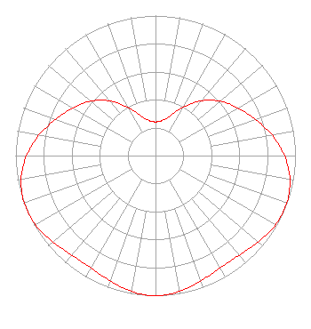 | |||||||||||||||||||
| Azimuth | Ratio | Azimuth | Ratio | Azimuth | Ratio | Azimuth | Ratio | |||||||||||||
| 0 | 0.241 | 10 | 0.253 | 20 | 0.302 | 30 | 0.397 | |||||||||||||
| 40 | 0.510 | 50 | 0.605 | 60 | 0.680 | 70 | 0.758 | |||||||||||||
| 80 | 0.845 | 90 | 0.922 | 100 | 0.975 | 110 | 0.997 | |||||||||||||
| 120 | 0.990 | 130 | 0.959 | 140 | 0.929 | 150 | 0.925 | |||||||||||||
| 160 | 0.951 | 170 | 0.985 | 180 | 1.000 | 190 | 0.985 | |||||||||||||
| 200 | 0.951 | 210 | 0.925 | 220 | 0.929 | 230 | 0.959 | |||||||||||||
| 240 | 0.990 | 250 | 0.997 | 260 | 0.975 | 270 | 0.922 | |||||||||||||
| 280 | 0.845 | 290 | 0.758 | 300 | 0.680 | 310 | 0.605 | |||||||||||||
| 320 | 0.510 | 330 | 0.397 | 340 | 0.302 | 350 | 0.253 | |||||||||||||
Structure Registration Number 1048806 Structure Type: TOWER Registered To: Gray Media Group, Inc. Structure Address: Highway # 185 North Bowling Green, KY County Name: Warren County ASR Issued: 09/09/2020 Date Built: 04/01/2011 Site Elevation: 225.6 m (740 ft.) Structure Height: 158.8 m (521 ft.) Height Overall: 171.9 m (564 ft.) Overall Height AMSL: 397.5 m (1304 ft.) FAA Determination: 02/17/2009 FAA Study #: 2008-ASO-1688-OE FAA Circular #: 70/7460-1J Paint & Light FAA Chapters: 3, 4, 5, 13 PRIOR STUDY 1998-ASO-2365-OE 37-03-49.2 N 86-26-06.7 W (NAD 83) 37-03-49.0 N 86-26-06.7 W (Converted to NAD 27) |
4370 Peachtree Road, Ne Atlanta, GA 30319 Phone: 202-750-1585 Limited Liability Company | Title: Assistant Secretary Date: 08/04/2020 Application Certifier Gray Television Licensee, Llc 4370 Peachtree Road, Ne Atlanta, GA 30319 Applicant Joan Stewart Wiley Rein Llp 1776 K Street, Nw Washington, DC 20006 | ||||||||||||||||||