
FCCInfo.com
A Service of Cavell, Mertz & Associates, Inc.
(855) FCC-INFO
|
|
WBFT-CD from 11/12/2004 WBFT-CD from 01/11/1989 |
Post-repack Channel 36 |
|
||||||||||||||||||||||
|
|
Repacking Information: Pre-Repack Channel: 46 Post-Repack Channel: 36 Post-Repack ERP: 0.024 kW Phase: 5 Completion Deadline: 9/11/2019 Find nearby TV Facilities Status: License Application Accepted: 10/14/2020 License Expires: 12/01/2020 File Number: -0000124673 FCC Website Links: LMS Facility Details This Application Other WBFT-CD Applications Including Superseded Applications Mailing Address Correspondence for WBFT-CD Correspondence related to application -0000124673 Service Contour - Open Street Map or USGS Map (51 dBu) Service Contour - KML / Google Earth (51 dBu) Public Inspection Files Rabbit Ears Info Search for WBFT-CD Site Location: 35-27-41.3 N 79-08-47.7 W (NAD 83) Site Location: 35-27-40.7 N 79-08-48.6 W (Converted to NAD 27) ERP: 10 kW Polarization: Horizontally polarized Electrical Beam Tilt: 1.5 degrees R/C AGL: 47.2 m (155 ft.) R/C AMSL: 178.9 m (587 ft.) Emission Mask: Stringent Site Elevation: 131.7 m. (432 ft.) Height Overall*: 61 m (200 ft.) (* As Filed In This Application, may differ from ASR Data, Below.) Directional Antenna - Antenna Make/Model: Dielectric TLP-8B Antenna ID: 1007461 Polarization: Horizontally polarized | ||||||||||||||||||||||||
| Antenna Data for Antenna Id: 1007461 WBFT-CD DC File: -0000124673 Dielectric - TLP-8B Service: DC Standard Pattern: N | 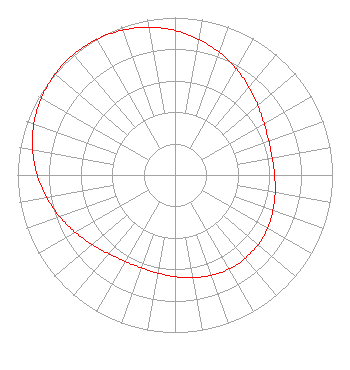 | ||||||||||||||||||||||||
| Azimuth | Ratio | Azimuth | Ratio | Azimuth | Ratio | Azimuth | Ratio | ||||||||||||||||||
| 0 | 0.918 | 10 | 0.875 | 20 | 0.828 | 30 | 0.778 | ||||||||||||||||||
| 40 | 0.729 | 50 | 0.686 | 60 | 0.653 | 70 | 0.633 | ||||||||||||||||||
| 80 | 0.627 | 90 | 0.632 | 100 | 0.646 | 110 | 0.662 | ||||||||||||||||||
| 120 | 0.678 | 130 | 0.689 | 140 | 0.692 | 150 | 0.689 | ||||||||||||||||||
| 160 | 0.678 | 170 | 0.662 | 180 | 0.646 | 190 | 0.632 | ||||||||||||||||||
| 200 | 0.627 | 210 | 0.633 | 220 | 0.653 | 230 | 0.686 | ||||||||||||||||||
| 240 | 0.729 | 250 | 0.778 | 260 | 0.828 | 270 | 0.875 | ||||||||||||||||||
| 280 | 0.918 | 290 | 0.953 | 300 | 0.979 | 310 | 0.995 | ||||||||||||||||||
| 320 | 1.000 | 330 | 0.995 | 340 | 0.979 | 350 | 0.953 | ||||||||||||||||||
Structure Registration Number 1021844 Structure Type: MTOWER Registered To: Crown Castle South LLC Structure Address: 2225 South Horner Boulevard Sanford, NC County Name: Lee County ASR Issued: 05/06/2016 Date Built: 07/22/1997 Site Elevation: 131.7 m (432 ft.) Structure Height: 58.5 m (192 ft.) Height Overall: 61 m (200 ft.) Overall Height AMSL: 192.7 m (632 ft.) FAA Determination: 09/28/2012 FAA Study #: 2012-ASO-8762-OE Paint & Light FAA Chapters: NONE PRIOR STUDY 2012-ASO-8121-OE 35-27-41.3 N 79-08-47.7 W (NAD 83) 35-27-40.7 N 79-08-48.6 W (Converted to NAD 27) |
Marion, IL 62959 Phone: 618-997-9333 Not-for-Profit | Title: General Manager Date: 10/14/2020 Application Certifier SANFORD BROADCASTING GROUP, INC. Sanford Broadcasting Group, Inc. Post Office Box 4646 Sanford, NC 27331 Applicant Kevin T. Fisher Smith And Fisher, Llc 4791 Wintergreen Court Woodbridge, VA 22192 President Elizabeth E. Spainhour Brooks, Pierce Et Al. 150 Fayetteville Street Suite 1700 Raleigh, NC 27601 | |||||||||||||||||||||||
| |||||||||||||||||||||||||