
FCCInfo.com
A Service of Cavell, Mertz & Associates, Inc.
(855) FCC-INFO
|
|
WPEM-LD from 08/12/2008 WPEM-LD from 10/10/2007 WPEM-LD from 08/23/1996 WPEM-LD from 04/17/1995 |
|
|
||||||||||||||||
|
|
Status: License Application Accepted: 09/15/2020 License Expires: 12/01/2020 File Number: -0000121677 FCC Website Links: LMS Facility Details This Application Other WPEM-LD Applications Including Superseded Applications Mailing Address Correspondence for WPEM-LD Correspondence related to application -0000121677 Service Contour - Open Street Map or USGS Map (51 dBu) Service Contour - KML / Google Earth (51 dBu) Rabbit Ears Info Search for WPEM-LD Site Location: 34-40-27.0 N 79-02-20.1 W (NAD 83) Site Location: 34-40-26.4 N 79-02-21.0 W (Converted to NAD 27) ERP: 2.3 kW Polarization: Circularly polarized R/C AGL: 148 m (486 ft.) R/C AMSL: 191.9 m (630 ft.) Emission Mask: Full Service Site Elevation: 43.9 m. (144 ft.) Height Overall*: 154.2 m (506 ft.) (* As Filed In This Application, may differ from ASR Data, Below.) Directional Antenna - Antenna Make/Model: Systems With Reliability Inc. SWLP8OI Antenna ID: 24202 Polarization: Circularly polarized | ||||||||||||||||||
| Antenna Data for Antenna Id: 24202 WPEM-LD LD File: -0000121677 Systems With Reliability Inc. - SWLP8OI Service: LD Standard Pattern: Y Pattern and Field Values Include a 215° Clockwise Rotation | 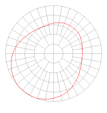 | ||||||||||||||||||
| Azimuth | Ratio | Azimuth | Ratio | Azimuth | Ratio | Azimuth | Ratio | ||||||||||||
| 5 | 0.640 | 15 | 0.660 | 25 | 0.670 | 35 | 0.670 | ||||||||||||
| 45 | 0.670 | 55 | 0.660 | 65 | 0.640 | 75 | 0.620 | ||||||||||||
| 85 | 0.600 | 95 | 0.600 | 105 | 0.610 | 115 | 0.630 | ||||||||||||
| 125 | 0.660 | 135 | 0.710 | 145 | 0.760 | 155 | 0.820 | ||||||||||||
| 165 | 0.870 | 175 | 0.910 | 185 | 0.950 | 195 | 0.980 | ||||||||||||
| 205 | 1.000 | 215 | 1.000 | 225 | 1.000 | 235 | 0.980 | ||||||||||||
| 245 | 0.950 | 255 | 0.910 | 265 | 0.870 | 275 | 0.820 | ||||||||||||
| 285 | 0.760 | 295 | 0.710 | 305 | 0.660 | 315 | 0.630 | ||||||||||||
| 325 | 0.610 | 335 | 0.600 | 345 | 0.600 | 355 | 0.620 | ||||||||||||
Structure Registration Number 1007489 Structure Type: TOWER Registered To: Pinnacle Towers LLC Structure Address: Hwy 211 At Sr 1532 Lumberton, NC County Name: Robeson County ASR Issued: 05/06/2016 Date Built: 01/01/1995 Site Elevation: 43.9 m (144 ft.) Structure Height: 152.4 m (500 ft.) Height Overall: 154.2 m (506 ft.) Overall Height AMSL: 198.1 m (650 ft.) FAA Determination: 08/24/2007 FAA Study #: 2007-ASO-4146-OE FAA Circular #: 70/7460-1J Paint & Light FAA Chapters: 3, 4, 6, 13 PRIOR STUDY 1999-ASO-356-OE 34-40-27.0 N 79-02-20.1 W (NAD 83) 34-40-26.4 N 79-02-21.0 W (Converted to NAD 27) |
Lumberton, NC 28360 Phone: 910-739-4477 Individual | Title: Owner Date: 09/15/2020 Application Certifier GERALD LOCKLEAR 2450 Nc Highway 211 W Lumberton, NC 28360 Applicant Richard Goetz R & L Media Systems 135 N Country Club Dr Hendersonville, TN 37075 Broadcast Consultant Gerald Locklear Gerald Locklear 2450 Hwy 211 West Lumberton, NC 24090 Coe W. Ramsey Brooks, Pierce Et Al. 150 Fayetteville Street Suite 1700 Raleigh, NC 27601 | |||||||||||||||||