
FCCInfo.com
A Service of Cavell, Mertz & Associates, Inc.
(855) FCC-INFO
|
|
|
|
|
||||||||||||||||
|
|
Status: License Application Accepted: 03/22/2021 License Expires: 02/01/2021 File Number: -0000140580 FCC Website Links: LMS Facility Details This Application Other W08EI-D Applications Including Superseded Applications Mailing Address Correspondence for W08EI-D Correspondence related to application -0000140580 Service Contour - Open Street Map or USGS Map (48 dBu) Service Contour - KML / Google Earth (48 dBu) Rabbit Ears Info Search for W08EI-D Site Location: 18-16-46.4 N 65-56-35.8 W (NAD 83) Site Location: 18-16-53.6 N 65-56-37.2 W (Converted to NAD 27) ERP: 3 kW Polarization: Horizontally polarized Electrical Beam Tilt: 1.5 degrees R/C AGL: 30.5 m (100 ft.) R/C AMSL: 513.6 m (1685 ft.) Emission Mask: Full Service Site Elevation: 483.1 m. (1585 ft.) Height Overall*: 93.3 m (306 ft.) (* As Filed In This Application, may differ from ASR Data, Below.) Directional Antenna - Antenna Make/Model: KATHREIN DRV Array Antenna ID: 1007993 Polarization: Horizontally polarized
| ||||||||||||||||||
| Antenna Data for Antenna Id: 1007993 W08EI-D LD File: -0000140580 KATHREIN - DRV Array Service: LD Standard Pattern: N Pattern and Field Values Include a 355° Clockwise Rotation | 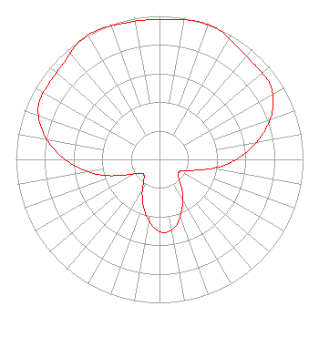 | ||||||||||||||||||
| Azimuth | Ratio | Azimuth | Ratio | Azimuth | Ratio | Azimuth | Ratio | ||||||||||||
| 5 | 0.980 | 15 | 0.996 | 20 | 1.000 | 25 | 0.992 | ||||||||||||
| 35 | 0.953 | 45 | 0.934 | 55 | 0.933 | 65 | 0.874 | ||||||||||||
| 75 | 0.756 | 85 | 0.612 | 95 | 0.454 | 105 | 0.286 | ||||||||||||
| 115 | 0.184 | 125 | 0.162 | 135 | 0.191 | 145 | 0.278 | ||||||||||||
| 155 | 0.372 | 165 | 0.468 | 175 | 0.511 | 185 | 0.477 | ||||||||||||
| 195 | 0.385 | 205 | 0.285 | 215 | 0.194 | 225 | 0.153 | ||||||||||||
| 235 | 0.168 | 245 | 0.256 | 255 | 0.420 | 265 | 0.581 | ||||||||||||
| 275 | 0.729 | 285 | 0.854 | 295 | 0.927 | 305 | 0.935 | ||||||||||||
| 315 | 0.946 | 325 | 0.989 | 332 | 1.000 | 335 | 0.998 | ||||||||||||
| 345 | 0.982 | 355 | 0.976 | ||||||||||||||||
Structure Registration Number 1011400 Structure Type: LTOWER Registered To: American Towers LLC Structure Address: 9.4 Nautical Miles Se Of Luis Munoz Marin Int L Airport (207216 ) Juncos, PR County Name: Gurabo Municipio ASR Issued: 11/29/2023 Date Built: 01/01/1990 Site Elevation: 483.1 m (1585 ft.) Structure Height: 91.7 m (301 ft.) Height Overall: 93.2 m (306 ft.) Overall Height AMSL: 576.3 m (1891 ft.) FAA Determination: 07/10/2023 FAA Study #: 2023-ASO-2277-OE FAA Circular #: 70/7460-1J Paint & Light FAA Chapters: 3, 4, 5, 13 PRIOR STUDY 2000-ASO-272-OE 18-16-46.4 N 65-56-35.8 W (NAD 83) 18-16-53.6 N 65-56-37.2 W (Converted to NAD 27) |
San Juan, PR 00919 Phone: 787-717-6984 Individual | Title: Licensee/sole Owner Date: 03/22/2021 Application Certifier ALEJANDRO LUCIANO Po Box 194528 San Juan, PR 00919 Applicant ALEJANDRO Luciano, Luciano Alejandro Luciano Pe Po Box 194528 San Juan, PR 00919 ALEJANDRO LUCIANO Alejandro Luciano Pe Po Box 194528 San Juan, PR 00919 | |||||||||||||||||