
FCCInfo.com
A Service of Cavell, Mertz & Associates, Inc.
(855) FCC-INFO
|
|
|
Virtual Channel 3 |
|
||||||||||||||||
|
|
Repacking Information: No changes Status: License Application Accepted: 10/02/2020 License Expires: 06/01/2022 File Number: -0000123803 FCC Website Links: LMS Facility Details This Application Other KLNE-TV Applications Including Superseded Applications Mailing Address Correspondence for KLNE-TV Correspondence related to application -0000123803 Service Contour - Open Street Map or USGS Map (41 dBu) Service Contour - KML / Google Earth (41 dBu) Public Inspection Files History Cards for KLNE-TV Rabbit Ears Info Search for KLNE-TV Site Location: 40-23-05.0 N 99-27-32.0 W (NAD 83) Site Location: 40-23-05.0 N 99-27-30.6 W (Converted to NAD 27) ERP: 425 kW Polarization: Horizontally polarized HAAT: 332.4 m (1091 ft.) Electrical Beam Tilt: 0.75 degrees R/C AGL: 315.5 m (1035 ft.) R/C AMSL: 1042.2 m (3419 ft.) Site Elevation: 726.7 m. (2384 ft.) Height Overall*: 323.4 m (1061 ft.) (* As Filed In This Application, may differ from ASR Data, Below.) Directional Antenna - Antenna Make/Model: Electronics Research Inc. ATW22H3-HTS-26S Antenna ID: 75596 Polarization: Horizontally polarized | ||||||||||||||||||
| Antenna Data for Antenna Id: 75596 KLNE-TV DT File: -0000123803 Electronics Research Inc. - ATW22H3-HTS-26S Service: DT Standard Pattern: Y | 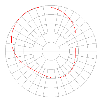 | ||||||||||||||||||
| Azimuth | Ratio | Azimuth | Ratio | Azimuth | Ratio | Azimuth | Ratio | ||||||||||||
| 0 | 0.952 | 10 | 0.915 | 20 | 0.868 | 30 | 0.813 | ||||||||||||
| 40 | 0.753 | 50 | 0.691 | 60 | 0.632 | 70 | 0.583 | ||||||||||||
| 80 | 0.550 | 90 | 0.536 | 100 | 0.539 | 110 | 0.556 | ||||||||||||
| 120 | 0.578 | 130 | 0.599 | 140 | 0.614 | 150 | 0.619 | ||||||||||||
| 160 | 0.614 | 170 | 0.599 | 180 | 0.578 | 190 | 0.556 | ||||||||||||
| 200 | 0.539 | 210 | 0.536 | 220 | 0.550 | 230 | 0.583 | ||||||||||||
| 240 | 0.632 | 250 | 0.691 | 260 | 0.753 | 270 | 0.813 | ||||||||||||
| 280 | 0.868 | 290 | 0.915 | 300 | 0.952 | 310 | 0.979 | ||||||||||||
| 320 | 0.995 | 330 | 1.000 | 340 | 0.995 | 350 | 0.979 | ||||||||||||
Structure Registration Number 1029929 Structure Type: GTOWER Registered To: NEBRASKA EDUCATIONAL TELECOMMUNICATION COMMISSION Structure Address: 72821 J Road Holdrege, NE County Name: Phelps County ASR Issued: 06/16/2020 Date Built: 06/15/2007 Site Elevation: 726.7 m (2384 ft.) Structure Height: 308.4 m (1012 ft.) Height Overall: 323.4 m (1061 ft.) Overall Height AMSL: 1050.1 m (3445 ft.) FAA Determination: 03/30/2020 FAA Study #: 2019-ACE-8971-OE FAA Circular #: 70/7460-1L Paint & Light FAA Chapters: 4, 9, 12 40-23-05.0 N 99-27-32.0 W (NAD 83) 40-23-05.0 N 99-27-30.6 W (Converted to NAD 27) |
1800 N. 33rd Street Lincoln, NE 68503 Phone: 402-472-9333 Government Entity | Title: Cto Date: 10/02/2020 Application Certifier Nebraska Educational Telecommunications Commission 1800 N. 33rd Street Lincoln, NE 68503 Applicant Barry S. Persh Gray Miller Persh Llp 2233 Wisconsin Avenue Nw Suite 226 Washington, DC 20007 Matthew Sperling Net 1800 N. 33rd Street Lincoln, NE 68503 Systems Engineer Douglas Lee Vernier Doug Vernier, Telecommunications Consultants, Llc 8893 Lakes Blvd West Palm Beach, FL 33412 Engineering Consultant | |||||||||||||||||