
FCCInfo.com
A Service of Cavell, Mertz & Associates, Inc.
(855) FCC-INFO
|
|
KMMW-LD from 07/20/2000 KMMW-LD from 05/17/2000 KMMW-LD from 10/08/1998 |
Virtual Channel 33 |
|
||||||||||||||||
|
|
Status: License Application Accepted: 10/23/2020 License Expires: 12/01/2022 File Number: -0000125019 FCC Website Links: LMS Facility Details This Application Other KMMW-LD Applications Including Superseded Applications Mailing Address Correspondence for KMMW-LD Correspondence related to application -0000125019 Service Contour - Open Street Map or USGS Map (51 dBu) Service Contour - KML / Google Earth (51 dBu) Rabbit Ears Info Search for KMMW-LD Site Location: 38-07-09.7 N 120-43-30.9 W (NAD 83) Site Location: 38-07-10.0 N 120-43-27.1 W (Converted to NAD 27) ERP: 5.9 kW Polarization: Horizontally polarized Electrical Beam Tilt: 2 degrees R/C AGL: 96.3 m (316 ft.) R/C AMSL: 930.8 m (3054 ft.) Emission Mask: Stringent Site Elevation: 834.5 m. (2738 ft.) Height Overall*: 126.5 m (415 ft.) (* As Filed In This Application, may differ from ASR Data, Below.) Directional Antenna - Antenna Make/Model: MCX SFN-2030-G-8 Antenna ID: 1007486 Polarization: Horizontally polarized | ||||||||||||||||||
| Antenna Data for Antenna Id: 1007486 KMMW-LD LD File: -0000125019 MCX - SFN-2030-G-8 Service: LD Standard Pattern: N Pattern and Field Values Include a 226° Clockwise Rotation | 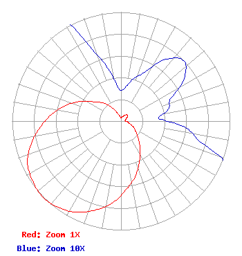 | ||||||||||||||||||
| Azimuth | Ratio | Azimuth | Ratio | Azimuth | Ratio | Azimuth | Ratio | ||||||||||||
| 6 | 0.030 | 16 | 0.040 | 26 | 0.050 | 36 | 0.070 | ||||||||||||
| 46 | 0.080 | 56 | 0.070 | 66 | 0.050 | 76 | 0.045 | ||||||||||||
| 86 | 0.035 | 96 | 0.060 | 106 | 0.080 | 116 | 0.130 | ||||||||||||
| 126 | 0.170 | 136 | 0.230 | 146 | 0.315 | 156 | 0.415 | ||||||||||||
| 166 | 0.530 | 176 | 0.635 | 186 | 0.755 | 196 | 0.850 | ||||||||||||
| 206 | 0.930 | 216 | 0.980 | 226 | 1.000 | 236 | 0.980 | ||||||||||||
| 246 | 0.940 | 256 | 0.850 | 266 | 0.740 | 276 | 0.635 | ||||||||||||
| 286 | 0.525 | 296 | 0.410 | 306 | 0.300 | 316 | 0.230 | ||||||||||||
| 326 | 0.150 | 336 | 0.080 | 346 | 0.050 | 356 | 0.030 | ||||||||||||
Structure Registration Number 1050375 Structure Type: GTOWER Registered To: American Towers LLC Structure Address: 4660 Riata Way (274586 / Bear Mountain T1 Ca) Altaville, CA County Name: Calaveras County ASR Issued: 10/21/2015 Date Built: 09/02/1998 Site Elevation: 834.5 m (2738 ft.) Structure Height: 125 m (410 ft.) Height Overall: 126.5 m (415 ft.) Overall Height AMSL: 961 m (3153 ft.) FAA Determination: 10/08/2015 FAA Study #: 2015-AWP-9041-OE FAA Circular #: 70/7460-1K Paint & Light FAA Chapters: 4, 8, 12 OM&L to remain the same as prior study = A MED-DUAL SYSTEM 38-07-09.7 N 120-43-30.9 W (NAD 83) 38-07-10.0 N 120-43-27.1 W (Converted to NAD 27) |
300 New Jersey Avenue, Nw Suite 700 Washington, DC 20001 Phone: 202-524-6401 Limited Liability Company | Title: Assistant Secretary Date: 10/23/2020 Application Certifier Nbc Telemundo License Llc 300 New Jersey Avenue, Nw Suite 700 Washington, DC 20001 Applicant S. Merrill Weiss Merrill Weiss Group Llc 227 Central Avenue Metuchen, NJ 08840-1242 H. Douglas Lung Nbc Honomu, HI 96728 Corporate engineering manager Margaret L Tobey C/o Nbcuniversal 300 New Jersey Avenue, Nw Suite 700 Washington, DC 20001 | |||||||||||||||||