
FCCInfo.com
A Service of Cavell, Mertz & Associates, Inc.
(855) FCC-INFO
|
|
W33EI-D from 05/17/2011 W33EI-D from 06/29/1992 |
|
|
||||||||||||||||
|
|
Status: License Application Accepted: 10/23/2020 License Expires: 12/01/2020 File Number: -0000125022 FCC Website Links: LMS Facility Details This Application Other W33EI-D Applications Including Superseded Applications Mailing Address Correspondence for W33EI-D Correspondence related to application -0000125022 Service Contour - Open Street Map or USGS Map (51 dBu) Service Contour - KML / Google Earth (51 dBu) Rabbit Ears Info Search for W33EI-D Site Location: 35-42-51.0 N 78-49-03.0 W (NAD 83) Site Location: 35-42-50.4 N 78-49-04.0 W (Converted to NAD 27) ERP: 15 kW Polarization: Elliptically polarized Electrical Beam Tilt: 1 degree R/C AGL: 206 m (676 ft.) R/C AMSL: 349.3 m (1146 ft.) Emission Mask: Full Service Site Elevation: 143.3 m. (470 ft.) Height Overall*: 481.3 m (1579 ft.) (* As Filed In This Application, may differ from ASR Data, Below.) Directional Antenna - Antenna Make/Model: Micronetixx CS-2030-5645-8 E/P Antenna ID: 1007487 Polarization: Elliptically polarized | ||||||||||||||||||
| Antenna Data for Antenna Id: 1007487 W33EI-D LD File: -0000125022 Micronetixx - CS-2030-5645-8 E/P Service: LD Standard Pattern: N Pattern and Field Values Include a 60° Clockwise Rotation | 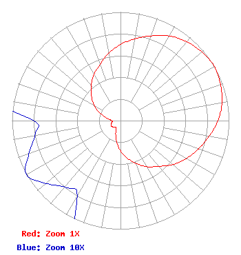 | ||||||||||||||||||
| Azimuth | Ratio | Azimuth | Ratio | Azimuth | Ratio | Azimuth | Ratio | ||||||||||||
| 0 | 0.700 | 10 | 0.765 | 20 | 0.830 | 30 | 0.900 | ||||||||||||
| 40 | 0.950 | 50 | 0.980 | 60 | 1.000 | 70 | 0.980 | ||||||||||||
| 80 | 0.950 | 90 | 0.900 | 100 | 0.830 | 110 | 0.765 | ||||||||||||
| 120 | 0.700 | 130 | 0.630 | 140 | 0.550 | 150 | 0.490 | ||||||||||||
| 160 | 0.420 | 170 | 0.350 | 180 | 0.280 | 190 | 0.200 | ||||||||||||
| 200 | 0.130 | 210 | 0.080 | 220 | 0.080 | 230 | 0.090 | ||||||||||||
| 240 | 0.100 | 250 | 0.090 | 260 | 0.080 | 270 | 0.080 | ||||||||||||
| 280 | 0.130 | 290 | 0.200 | 300 | 0.280 | 310 | 0.350 | ||||||||||||
| 320 | 0.420 | 330 | 0.490 | 340 | 0.550 | 350 | 0.630 | ||||||||||||
Structure Registration Number 1008598 Structure Type: TOWER Registered To: Vertical Bridge CC FM, LLC Structure Address: 1.5 Mi Se Apex, NC County Name: Wake County ASR Issued: 11/08/2018 Date Built: 01/01/1986 Site Elevation: 143.3 m (470 ft.) Structure Height: 480.3 m (1576 ft.) Height Overall: 481.3 m (1579 ft.) Overall Height AMSL: 624.6 m (2049 ft.) FAA Determination: 10/29/1996 FAA Study #: 96-ASO-5364-OE FAA Circular #: 70/7460-1J Paint & Light FAA Chapters: 4, 7, 13 35-42-51.0 N 78-49-03.0 W (NAD 83) 35-42-50.4 N 78-49-04.0 W (Converted to NAD 27) |
One Hsn Drive St. Petersburg, FL 33729 Phone: 727-872-4210 Corporation | Title: Senior Vp Date: 10/23/2020 Application Certifier Ventana Television, Inc. One Hsn Drive St. Petersburg, FL 33729 Applicant JOHN COLLINSON Ventana Television Inc. 1 Hsn Drive Saint Petersburg, FL 33729 TECHNICAL REPRESENTATIVE Gregg P Skall, Esq. Telecommunications Law Professionals Pllc 1025 Connecticut Ave, Nw Suite 1011 Washington, DC 20036 Legal Counsel ERIC YONKIN Ventana Television Inc. 1 Hsn Drive Saint Petersburg, FL 33729 LEGAL REPRESENTATIVE | |||||||||||||||||