
FCCInfo.com
A Service of Cavell, Mertz & Associates, Inc.
(855) FCC-INFO
|
|
|
|
|||||||||||||||||
|
|
Status: STA – Special Temporary Authority Application Accepted: 11/02/2020 STA Expires: 00/00/0000 File Number: - FCC Website Links: LMS Facility Details This Application Other K35KC-D Applications Including Superseded Applications Mailing Address Correspondence for K35KC-D Correspondence related to application - Service Contour - Open Street Map or USGS Map (43 dBu) Service Contour - KML / Google Earth (43 dBu) Rabbit Ears Info Search for K35KC-D Site Location: 47-27-51.8 N 111-21-21.1 W (NAD 83) Site Location: 47-27-52.0 N 111-21-18.2 W (Converted to NAD 27) ERP: 0.1 kW Polarization: Horizontally polarized R/C AGL: 5 m (16 ft.) R/C AMSL: 1130.9 m (3710 ft.) Emission Mask: Simple Site Elevation: 1125.9 m. (3694 ft.) Height Overall*: 27.4 m (90 ft.) (* As Filed In This Application, may differ from ASR Data, Below.) Directional Antenna - Antenna Make/Model: Scala CL-1469 Antenna ID: 20778 Polarization: Horizontally polarized | ||||||||||||||||||
| Antenna Data for Antenna Id: 20778 K35KC-D LD File: Scala - CL-1469 Service: LD Standard Pattern: Y Pattern and Field Values Include a 45° Clockwise Rotation | 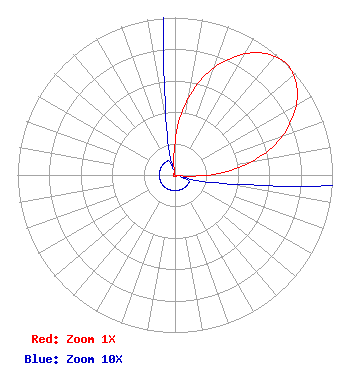 | ||||||||||||||||||
| Azimuth | Ratio | Azimuth | Ratio | Azimuth | Ratio | Azimuth | Ratio | ||||||||||||
| 5 | 0.361 | 15 | 0.622 | 25 | 0.812 | 35 | 0.947 | ||||||||||||
| 45 | 1.000 | 55 | 0.947 | 65 | 0.812 | 75 | 0.622 | ||||||||||||
| 85 | 0.361 | 95 | 0.086 | 105 | 0.010 | 115 | 0.010 | ||||||||||||
| 125 | 0.010 | 135 | 0.010 | 145 | 0.010 | 155 | 0.010 | ||||||||||||
| 165 | 0.010 | 175 | 0.010 | 185 | 0.010 | 195 | 0.010 | ||||||||||||
| 205 | 0.010 | 215 | 0.010 | 225 | 0.010 | 235 | 0.010 | ||||||||||||
| 245 | 0.010 | 255 | 0.010 | 265 | 0.010 | 275 | 0.010 | ||||||||||||
| 285 | 0.010 | 295 | 0.010 | 305 | 0.010 | 315 | 0.010 | ||||||||||||
| 325 | 0.010 | 335 | 0.010 | 345 | 0.010 | 355 | 0.086 | ||||||||||||
Structure Registration Number 1265983 Structure Type: TOWER Registered To: Hi-Line Radio Fellowship, Inc. Structure Address: 3001 47th Avenue Sw Great Falls, MT County Name: Cascade County ASR Issued: 10/22/2011 Date Built: 12/01/2011 Site Elevation: 1125.9 m (3694 ft.) Structure Height: 27.4 m (90 ft.) Height Overall: 27.4 m (90 ft.) Overall Height AMSL: 1153.3 m (3784 ft.) FAA Determination: 10/13/2011 FAA Study #: 2011-ANM-2045-OE Paint & Light FAA Chapters: NONE PRIOR STUDY 2008-ANM-1232-OE 47-27-51.8 N 111-21-21.1 W (NAD 83) 47-27-52.0 N 111-21-18.2 W (Converted to NAD 27) |
Hurst, TX 76054 Phone: 214-770-7770 Corporation | Title: Ceo Date: 11/02/2020 Application Certifier EDGE SPECTRUM, INC. Edge Spectrum, Inc. Po Box: 54025 Hurst, TX 76054 Applicant Randy Weiss Weiss Edge Spectrum, Inc. Hurst, TX 76054 Susan Hansen Hansen B. W. St. Clair 2305 Vida Shaw Rd. New Iberia, LA 70563 Randy Weiss Weiss Edge Spectrum, Inc. Hurst, TX 76054 | |||||||||||||||||