
FCCInfo.com
A Service of Cavell, Mertz & Associates, Inc.
(855) FCC-INFO
|
|
|
|
|
||||||||||||||||
|
|
Status: License Application Accepted: 11/13/2020 License Expires: 06/01/2021 File Number: -0000125986 FCC Website Links: LMS Facility Details This Application Other KCWL-LD Applications Including Superseded Applications Mailing Address Correspondence for KCWL-LD Correspondence related to application -0000125986 Service Contour - Open Street Map or USGS Map (51 dBu) Service Contour - KML / Google Earth (51 dBu) Rabbit Ears Info Search for KCWL-LD Site Location: 32-31-40.0 N 92-06-08.7 W (NAD 83) Site Location: 32-31-39.5 N 92-06-08.2 W (Converted to NAD 27) ERP: 15 kW Polarization: Elliptically polarized Electrical Beam Tilt: 1.5 degrees R/C AGL: 172.5 m (566 ft.) R/C AMSL: 195.1 m (640 ft.) Emission Mask: Full Service Site Elevation: 22.6 m. (74 ft.) Height Overall*: 236.2 m (775 ft.) (* As Filed In This Application, may differ from ASR Data, Below.) Directional Antenna - Antenna Make/Model: DIELECTRIC DLP-12B/VP Antenna ID: 1007551 Polarization: Elliptically polarized | ||||||||||||||||||
| Antenna Data for Antenna Id: 1007551 KCWL-LD LD File: -0000125986 DIELECTRIC - DLP-12B/VP Service: LD Standard Pattern: N | 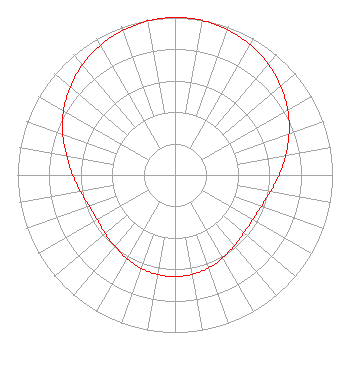 | ||||||||||||||||||
| Azimuth | Ratio | Azimuth | Ratio | Azimuth | Ratio | Azimuth | Ratio | ||||||||||||
| 0 | 1.000 | 10 | 0.996 | 20 | 0.981 | 30 | 0.955 | ||||||||||||
| 40 | 0.920 | 50 | 0.876 | 60 | 0.826 | 70 | 0.771 | ||||||||||||
| 80 | 0.714 | 90 | 0.661 | 100 | 0.615 | 110 | 0.583 | ||||||||||||
| 120 | 0.569 | 130 | 0.571 | 140 | 0.586 | 150 | 0.607 | ||||||||||||
| 160 | 0.627 | 170 | 0.640 | 180 | 0.645 | 190 | 0.641 | ||||||||||||
| 200 | 0.631 | 210 | 0.613 | 220 | 0.592 | 230 | 0.579 | ||||||||||||
| 240 | 0.570 | 250 | 0.579 | 260 | 0.610 | 270 | 0.650 | ||||||||||||
| 280 | 0.699 | 290 | 0.759 | 300 | 0.817 | 310 | 0.869 | ||||||||||||
| 320 | 0.914 | 330 | 0.951 | 340 | 0.975 | 350 | 0.993 | ||||||||||||
Structure Registration Number 1239438 Structure Type: TOWER Registered To: NOE CORP LLC Structure Address: 1400 Oliver Road Monroe, LA County Name: Ouachita Parish ASR Issued: 07/03/2003 Date Built: 07/01/2003 Site Elevation: 22.6 m (74 ft.) Structure Height: 235.3 m (772 ft.) Height Overall: 236.2 m (775 ft.) Overall Height AMSL: 258.8 m (849 ft.) FAA Determination: 02/15/2002 FAA Study #: 00-ASW-3965-OE FAA Circular #: 70/7460-1K Paint & Light FAA Chapters: 4, 9, 12 Removed expiration and final dates from determination. Scenario 2./jjs/case#635066 32-31-40.0 N 92-06-08.7 W (NAD 83) 32-31-39.5 N 92-06-08.2 W (Converted to NAD 27) |
4370 Peachtree Road, Ne Atlanta, GA 30319 Phone: 202-750-1585 Limited Liability Company | Title: Assistant Secretary Date: 11/13/2020 Application Certifier Gray Television Licensee, Llc 4370 Peachtree Road, Ne Atlanta, GA 30319 Applicant Joseph M. Davis, P.E. Chesapeake Rf Consultants, Llc 207 Old Dominion Road Yorktown, VA 23692 Consulting Engineer Joan Stewart Wiley Rein Llp 1776 K Street, Nw Washington, DC 20006 | |||||||||||||||||