
FCCInfo.com
A Service of Cavell, Mertz & Associates, Inc.
(855) FCC-INFO
|
|
WDTA-LD from 07/12/2001 WDTA-LD from 07/09/2001 WDTA-LD from 10/12/1998 WDTA-LD from 07/29/1998 WDTA-LD from 04/01/1998 WDTA-LD from 03/10/1998 |
|
|
||||||||||||||||
|
|
Status: License Application Accepted: 11/19/2020 License Expires: 04/01/2021 File Number: -0000126643 FCC Website Links: LMS Facility Details This Application Other WDTA-LD Applications Including Superseded Applications Mailing Address Correspondence for WDTA-LD Correspondence related to application -0000126643 Service Contour - Open Street Map or USGS Map (51 dBu) Service Contour - KML / Google Earth (51 dBu) Rabbit Ears Info Search for WDTA-LD Site Location: 33-44-40.9 N 84-21-35.7 W (NAD 83) Site Location: 33-44-40.5 N 84-21-36.0 W (Converted to NAD 27) ERP: 6 kW Polarization: Elliptically polarized Electrical Beam Tilt: .75 degrees R/C AGL: 317.6 m (1042 ft.) R/C AMSL: 613 m (2011 ft.) Emission Mask: Full Service Site Elevation: 295.4 m. (969 ft.) Height Overall*: 329.2 m (1080 ft.) (* As Filed In This Application, may differ from ASR Data, Below.) Directional Antenna - Antenna Make/Model: R.F. Systems PEPL48C-C170-2-T Antenna ID: 1005561 Polarization: Elliptically polarized | ||||||||||||||||||
| Antenna Data for Antenna Id: 1005561 WDTA-LD LD File: -0000126643 R.F. Systems - PEPL48C-C170-2-T Service: LD Standard Pattern: Y | 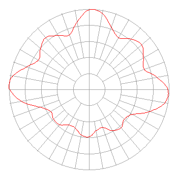 | ||||||||||||||||||
| Azimuth | Ratio | Azimuth | Ratio | Azimuth | Ratio | Azimuth | Ratio | ||||||||||||
| 0 | 0.989 | 10 | 0.960 | 20 | 0.818 | 30 | 0.740 | ||||||||||||
| 40 | 0.817 | 50 | 0.859 | 60 | 0.784 | 70 | 0.732 | ||||||||||||
| 80 | 0.861 | 90 | 0.984 | 100 | 0.961 | 110 | 0.806 | ||||||||||||
| 120 | 0.624 | 130 | 0.577 | 140 | 0.622 | 150 | 0.590 | ||||||||||||
| 160 | 0.505 | 170 | 0.522 | 180 | 0.590 | 190 | 0.572 | ||||||||||||
| 200 | 0.508 | 210 | 0.511 | 220 | 0.572 | 230 | 0.579 | ||||||||||||
| 240 | 0.550 | 250 | 0.648 | 260 | 0.853 | 270 | 0.988 | ||||||||||||
| 273 | 1.000 | 280 | 0.962 | 290 | 0.822 | 300 | 0.728 | ||||||||||||
| 310 | 0.789 | 320 | 0.839 | 330 | 0.773 | 340 | 0.718 | ||||||||||||
| 350 | 0.850 | ||||||||||||||||||
Structure Registration Number 1206253 Structure Type: GTOWER Registered To: American Towers LLC Structure Address: 315 Chester Avenue (#23656) Atlanta, GA County Name: Fulton County ASR Issued: 06/24/2016 Date Built: 05/14/2002 Site Elevation: 295.4 m (969 ft.) Structure Height: 291.4 m (956 ft.) Height Overall: 329.2 m (1080 ft.) Overall Height AMSL: 624.6 m (2049 ft.) FAA Determination: 02/11/2013 FAA Study #: 2013-ASO-269-OE FAA Circular #: 70/7460-1J Paint & Light FAA Chapters: 4, 9, 13 PRIOR STUDY 2011-ASO-7398-OE 33-44-40.9 N 84-21-35.7 W (NAD 83) 33-44-40.5 N 84-21-36.0 W (Converted to NAD 27) |
3901 Highway 121 South Bedford, TX 76021 Phone: 817-571-1229 Applicant | Title: President Date: 11/19/2020 Application Certifier WORD OF GOD FELLOWSHIP, INC. Word Of God Fellowship, Inc. 3901 Highway 121 South Bedford, TX 76021 Applicant RICHARD C GOETZ R & L Media Systems 135 N Country Club Dr Hendersonville, TN 37075 BROADCAST CONSULTANT ARNOLD TORRES Word Of God Fellowship, Inc. 3901 Hwy 121 Bedford, TX 76021 Manager | |||||||||||||||||