
FCCInfo.com
A Service of Cavell, Mertz & Associates, Inc.
(855) FCC-INFO
|
|
KDVR from 09/25/1981 KDVR from 06/08/1981 |
Post-repack Channel 36 Virtual Channel 31 |  |
|
|||||||||||||||||||||||||||||||||||||||||||||||||||||||||||||||||||||||||||||||||||||||||||||||||||||||||||||||||||
|
|
Repacking Information: Pre-Repack Channel: 32 Post-Repack Channel: 36 Post-Repack ERP: 1000 kW Phase: 9 Completion Deadline: 5/1/2020 Upstream/Downstream Dependencies Other Linked Stations Find nearby TV Facilities Status: License Application Accepted: 11/30/2020 License Expires: 04/01/2022 File Number: -0000128319 FCC Website Links: LMS Facility Details This Application Other KDVR Applications Including Superseded Applications Mailing Address Correspondence for KDVR Correspondence related to application -0000128319 Service Contour - Open Street Map or USGS Map (41 dBu) Service Contour - KML / Google Earth (41 dBu) Public Inspection Files History Cards for KDVR Rabbit Ears Info Search for KDVR Site Location: 39-43-42.1 N 105-14-15.7 W (NAD 83) Site Location: 39-43-42.1 N 105-14-13.7 W (Converted to NAD 27) ERP: 1000 kW Polarization: Elliptically polarized HAAT: 316 m (1037 ft.) Electrical Beam Tilt: 1 degree R/C AGL: 106 m (348 ft.) R/C AMSL: 2348.7 m (7706 ft.) Site Elevation: 2242.7 m. (7358 ft.) Height Overall*: 114.3 m (375 ft.) (* As Filed In This Application, may differ from ASR Data, Below.) Directional Antenna - Antenna Make/Model: DIELECTRIC TFU-26DSC/VP-R C170 MT Antenna ID: 1007643 Polarization: Elliptically polarized
| ||||||||||||||||||||||||||||||||||||||||||||||||||||||||||||||||||||||||||||||||||||||||||||||||||||||||||||||||||||||
| Antenna Data for Antenna Id: 1007643 KDVR DT File: -0000128319 DIELECTRIC - TFU-26DSC/VP-R C170 MT Service: DT Standard Pattern: N | 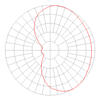 | ||||||||||||||||||||||||||||||||||||||||||||||||||||||||||||||||||||||||||||||||||||||||||||||||||||||||||||||||||||||
| Azimuth | Ratio | Azimuth | Ratio | Azimuth | Ratio | Azimuth | Ratio | ||||||||||||||||||||||||||||||||||||||||||||||||||||||||||||||||||||||||||||||||||||||||||||||||||||||||||||||||
| 0 | 0.969 | 10 | 0.999 | 20 | 1.000 | 30 | 0.983 | ||||||||||||||||||||||||||||||||||||||||||||||||||||||||||||||||||||||||||||||||||||||||||||||||||||||||||||||||
| 40 | 0.958 | 50 | 0.939 | 60 | 0.927 | 70 | 0.922 | ||||||||||||||||||||||||||||||||||||||||||||||||||||||||||||||||||||||||||||||||||||||||||||||||||||||||||||||||
| 80 | 0.921 | 90 | 0.922 | 100 | 0.927 | 110 | 0.939 | ||||||||||||||||||||||||||||||||||||||||||||||||||||||||||||||||||||||||||||||||||||||||||||||||||||||||||||||||
| 120 | 0.958 | 130 | 0.983 | 140 | 1.000 | 150 | 0.999 | ||||||||||||||||||||||||||||||||||||||||||||||||||||||||||||||||||||||||||||||||||||||||||||||||||||||||||||||||
| 160 | 0.969 | 170 | 0.902 | 180 | 0.820 | 190 | 0.686 | ||||||||||||||||||||||||||||||||||||||||||||||||||||||||||||||||||||||||||||||||||||||||||||||||||||||||||||||||
| 200 | 0.532 | 210 | 0.381 | 220 | 0.256 | 230 | 0.182 | ||||||||||||||||||||||||||||||||||||||||||||||||||||||||||||||||||||||||||||||||||||||||||||||||||||||||||||||||
| 240 | 0.170 | 250 | 0.186 | 260 | 0.195 | 270 | 0.186 | ||||||||||||||||||||||||||||||||||||||||||||||||||||||||||||||||||||||||||||||||||||||||||||||||||||||||||||||||
| 280 | 0.170 | 290 | 0.182 | 300 | 0.256 | 310 | 0.381 | ||||||||||||||||||||||||||||||||||||||||||||||||||||||||||||||||||||||||||||||||||||||||||||||||||||||||||||||||
| 320 | 0.532 | 330 | 0.686 | 340 | 0.820 | 350 | 0.902 | ||||||||||||||||||||||||||||||||||||||||||||||||||||||||||||||||||||||||||||||||||||||||||||||||||||||||||||||||
Structure Registration Number 1022259 Structure Type: LTOWER Registered To: Tribune Broadcasting Company II LLC Structure Address: 21214 Cedar Lake Rd Golden, CO County Name: Jefferson County ASR Issued: 01/16/2020 Date Built: 05/06/2014 Site Elevation: 2242.7 m (7358 ft.) Structure Height: 113.4 m (372 ft.) Height Overall: 114.3 m (375 ft.) Overall Height AMSL: 2357 m (7733 ft.) FAA Determination: 04/16/2013 FAA Study #: 2013-ANM-511-OE FAA Circular #: 70/7460-1K Paint & Light FAA Chapters: 3, 4, 5, 12 39-43-42.1 N 105-14-15.7 W (NAD 83) 39-43-42.1 N 105-14-13.7 W (Converted to NAD 27) |
545 E. John Carpenter Freeway Dallas, TX 75062 Phone: 972-373-8000 Limited Liability Company | Title: General Counsel Date: 11/30/2020 Application Certifier Tribune Broadcasting Company Ii Llc 545 E. John Carpenter Freeway Dallas, TX 75062 Applicant Louis R duTreil, Jr Dutreil Lundin & Rackley Inc 3135 Southgate Circle Sarasota, FL 34239 Technical Consultant Elizabeth Ryder Nexstar Broadcasting, Inc. 545 E John Carpenter Freeway Irving, TX 75062 General Counsel | |||||||||||||||||||||||||||||||||||||||||||||||||||||||||||||||||||||||||||||||||||||||||||||||||||||||||||||||||||||
| |||||||||||||||||||||||||||||||||||||||||||||||||||||||||||||||||||||||||||||||||||||||||||||||||||||||||||||||||||||||
