
FCCInfo.com
A Service of Cavell, Mertz & Associates, Inc.
(855) FCC-INFO
|
|
KEVU-CD from 03/29/1997 KEVU-CD from 04/15/1985 |
|  |
|
|||||||||||||||||||||||||||||||||||||||
|
|
Repacking Information: No changes Status: License Application Accepted: 12/07/2020 License Expires: 02/01/2023 File Number: -0000129446 FCC Website Links: LMS Facility Details This Application Other KEVU-CD Applications Including Superseded Applications Mailing Address Correspondence for KEVU-CD Correspondence related to application -0000129446 Service Contour - Open Street Map or USGS Map (51 dBu) Service Contour - KML / Google Earth (51 dBu) Public Inspection Files Rabbit Ears Info Search for KEVU-CD Site Location: 44-00-03.0 N 123-06-49.0 W (NAD 83) Site Location: 44-00-03.6 N 123-06-44.7 W (Converted to NAD 27) ERP: 7.66 kW Polarization: Horizontally polarized Electrical Beam Tilt: 1.4 degrees R/C AGL: 176.8 m (580 ft.) R/C AMSL: 571.8 m (1876 ft.) Emission Mask: Full Service Site Elevation: 395 m. (1296 ft.) Height Overall*: 199 m (653 ft.) (* As Filed In This Application, may differ from ASR Data, Below.) Directional Antenna - Antenna Make/Model: Kathrein 4X3 K723147 Antenna ID: 100453 Polarization: Horizontally polarized | ||||||||||||||||||||||||||||||||||||||||||
| Antenna Data for Antenna Id: 100453 KEVU-CD DC File: -0000129446 Kathrein - 4X3 K723147 Service: DC Standard Pattern: Y | 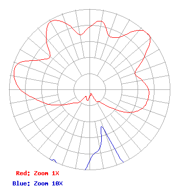 | ||||||||||||||||||||||||||||||||||||||||||
| Azimuth | Ratio | Azimuth | Ratio | Azimuth | Ratio | Azimuth | Ratio | ||||||||||||||||||||||||||||||||||||
| 0 | 0.775 | 10 | 0.859 | 20 | 0.711 | 30 | 0.751 | ||||||||||||||||||||||||||||||||||||
| 40 | 0.956 | 46 | 1.000 | 50 | 0.979 | 60 | 0.778 | ||||||||||||||||||||||||||||||||||||
| 70 | 0.602 | 80 | 0.661 | 90 | 0.731 | 100 | 0.736 | ||||||||||||||||||||||||||||||||||||
| 110 | 0.696 | 120 | 0.572 | 130 | 0.363 | 140 | 0.201 | ||||||||||||||||||||||||||||||||||||
| 150 | 0.173 | 160 | 0.054 | 170 | 0.074 | 180 | 0.089 | ||||||||||||||||||||||||||||||||||||
| 190 | 0.141 | 200 | 0.109 | 210 | 0.107 | 220 | 0.214 | ||||||||||||||||||||||||||||||||||||
| 230 | 0.265 | 240 | 0.385 | 250 | 0.542 | 260 | 0.683 | ||||||||||||||||||||||||||||||||||||
| 270 | 0.859 | 280 | 0.950 | 290 | 0.941 | 300 | 0.729 | ||||||||||||||||||||||||||||||||||||
| 310 | 0.639 | 320 | 0.838 | 330 | 0.970 | 340 | 0.878 | ||||||||||||||||||||||||||||||||||||
| 350 | 0.691 | ||||||||||||||||||||||||||||||||||||||||||
Structure Registration Number 1034933 Structure Type: Registered To: EIP Holdings II, LLC Structure Address: 4585 Blanton Rd Eugene, OR County Name: Lane County ASR Issued: 11/30/2023 Date Built: 01/01/1987 Site Elevation: 395 m (1296 ft.) Structure Height: 198.1 m (650 ft.) Height Overall: 199 m (653 ft.) Overall Height AMSL: 594 m (1949 ft.) FAA Determination: 06/04/1990 FAA Study #: 90-ANM-0325-OE FAA Circular #: 70/7460-1G Paint & Light FAA Chapters: 3, 4, 5, 9 44-00-03.0 N 123-06-49.0 W (NAD 83) 44-00-03.6 N 123-06-44.7 W (Converted to NAD 27) |
1601 West Peachtree Street, Ne Atlanta, GA 30309 Phone: 404-897-7000 Limited Partnership | Title: President Date: 12/07/2020 Application Certifier California Oregon Broadcasting, Inc. Medford, OR 97501 Applicant Kathy Kirby, Esq Wiley Rein Llp 1776 K Street, N.w. Washington, DC 20006 | |||||||||||||||||||||||||||||||||||||||||
| |||||||||||||||||||||||||||||||||||||||||||