
FCCInfo.com
A Service of Cavell, Mertz & Associates, Inc.
(855) FCC-INFO
|
|
WXOW from 07/21/1978 |
Post-repack Channel 28 Virtual Channel 19 |  |
|
||||||||||||||||||
|
|
Repacking Information: Pre-Repack Channel: 48 Post-Repack Channel: 28 Post-Repack ERP: 251 kW Phase: 0 Completion Deadline: 8/1/2018 Find nearby TV Facilities Status: License Application Accepted: 02/16/2021 License Expires: 12/01/2021 File Number: -0000136324 FCC Website Links: LMS Facility Details This Application Other WXOW Applications Including Superseded Applications Mailing Address Correspondence for WXOW Correspondence related to application -0000136324 Service Contour - Open Street Map or USGS Map (41 dBu) Service Contour - KML / Google Earth (41 dBu) Public Inspection Files Rabbit Ears Info Search for WXOW Site Location: 43-48-23.0 N 91-22-03.0 W (NAD 83) Site Location: 43-48-23.1 N 91-22-02.5 W (Converted to NAD 27) ERP: 99 kW Polarization: Horizontally polarized HAAT: 334.5 m (1097 ft.) Electrical Beam Tilt: 1.05 degrees R/C AGL: 229.4 m (753 ft.) R/C AMSL: 603 m (1978 ft.) Site Elevation: 373.6 m. (1226 ft.) Height Overall*: 249.7 m (819 ft.) (* As Filed In This Application, may differ from ASR Data, Below.) Directional Antenna - Antenna Make/Model: DIELECTRIC TFU-8WB-C160 Antenna ID: 1004018 Polarization: Horizontally polarized | |||||||||||||||||||||
| Antenna Data for Antenna Id: 1004018 WXOW DX File: -0000136324 DIELECTRIC - TFU-8WB-C160 Service: DX Standard Pattern: Y Pattern and Field Values Include a 70° Clockwise Rotation | 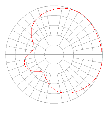 | |||||||||||||||||||||
| Azimuth | Ratio | Azimuth | Ratio | Azimuth | Ratio | Azimuth | Ratio | |||||||||||||||
| 0 | 0.920 | 10 | 0.956 | 20 | 0.984 | 30 | 0.998 | |||||||||||||||
| 35 | 1.000 | 40 | 0.998 | 50 | 0.987 | 60 | 0.976 | |||||||||||||||
| 70 | 0.971 | 80 | 0.976 | 90 | 0.988 | 100 | 0.998 | |||||||||||||||
| 105 | 1.000 | 110 | 0.998 | 120 | 0.984 | 130 | 0.956 | |||||||||||||||
| 140 | 0.921 | 150 | 0.883 | 160 | 0.842 | 170 | 0.788 | |||||||||||||||
| 180 | 0.713 | 190 | 0.612 | 200 | 0.504 | 210 | 0.435 | |||||||||||||||
| 220 | 0.452 | 230 | 0.533 | 240 | 0.610 | 250 | 0.640 | |||||||||||||||
| 260 | 0.609 | 270 | 0.531 | 280 | 0.450 | 290 | 0.433 | |||||||||||||||
| 300 | 0.503 | 310 | 0.611 | 320 | 0.711 | 330 | 0.786 | |||||||||||||||
| 340 | 0.840 | 350 | 0.882 | |||||||||||||||||||
Structure Registration Number 1035149 Structure Type: TOWER Registered To: La Crosse TV License Company, LLC Structure Address: 3705 Cth 25 La Crescent, MN County Name: Houston County ASR Issued: 08/19/2021 Date Built: 10/23/1982 Site Elevation: 373.6 m (1226 ft.) Structure Height: 232.7 m (763 ft.) Height Overall: 249.7 m (819 ft.) Overall Height AMSL: 623.3 m (2045 ft.) FAA Determination: 04/14/1983 FAA Study #: 82-AGL-53-OE FAA Circular #: 70/7460-1F Paint & Light FAA Chapters: 4, 6, 9 43-48-23.0 N 91-22-03.0 W (NAD 83) 43-48-23.1 N 91-22-02.5 W (Converted to NAD 27) |
1925 Century Park East, 10th Floor Los Angeles, CA 90067 Phone: 310-277-3500 Limited Liability Company | Title: President Date: 02/16/2021 Application Certifier WXOW-WQOW License, LLC Wxow-wqow License, Llc P.o. Box 909 Quincy, IL 62306 Applicant Stephen Hartzell Brooks, Pierce Et Al. 150 Fayetteville Street Suite 1700 Raleigh, NC 27601 Scott Turpie Lohnes & Culver, Llc Alexandria, VA 22302 Sr. Technical Consultant | ||||||||||||||||||||
| ||||||||||||||||||||||