
FCCInfo.com
A Service of Cavell, Mertz & Associates, Inc.
(855) FCC-INFO
|
|
KWWT from 07/01/1998 KWWT from 06/01/1998 |
Virtual Channel 30 |
|
||||||||||||||||
|
|
Repacking Information: No changes Status: STA – Special Temporary Authority Application Accepted: 00/00/0000 STA Expires: 00/00/0000 File Number: - FCC Website Links: LMS Facility Details This Application Other KWWT Applications Including Superseded Applications Mailing Address Correspondence for KWWT Correspondence related to application - Service Contour - Open Street Map or USGS Map (41 dBu) Service Contour - KML / Google Earth (41 dBu) Public Inspection Files Rabbit Ears Info Search for KWWT Site Location: 32-02-52.5 N 102-18-12.5 W (NAD 83) Site Location: 32-02-52.1 N 102-18-11.0 W (Converted to NAD 27) ERP: 37.5 kW Polarization: Horizontally polarized HAAT: 147 m (482 ft.) R/C AGL: 148 m (486 ft.) R/C AMSL: 1041.1 m (3416 ft.) Site Elevation: 893.1 m. (2930 ft.) Height Overall*: 152.1 m (499 ft.) (* As Filed In This Application, may differ from ASR Data, Below.) Directional Antenna - Antenna Make/Model: SBP UP-8-MEC Antenna ID: 89118 Polarization: Horizontally polarized | ||||||||||||||||||
| Antenna Data for Antenna Id: 89118 KWWT DT File: SBP - UP-8-MEC Service: DT Standard Pattern: Y | 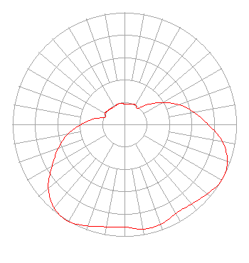 | ||||||||||||||||||
| Azimuth | Ratio | Azimuth | Ratio | Azimuth | Ratio | Azimuth | Ratio | ||||||||||||
| 0 | 0.183 | 10 | 0.185 | 20 | 0.193 | 30 | 0.200 | ||||||||||||
| 40 | 0.185 | 50 | 0.278 | 60 | 0.387 | 70 | 0.516 | ||||||||||||
| 80 | 0.629 | 90 | 0.747 | 100 | 0.887 | 110 | 0.977 | ||||||||||||
| 120 | 1.000 | 130 | 0.965 | 140 | 0.929 | 150 | 0.917 | ||||||||||||
| 160 | 0.950 | 170 | 0.950 | 180 | 0.917 | 190 | 0.929 | ||||||||||||
| 200 | 0.965 | 210 | 1.000 | 220 | 0.977 | 230 | 0.887 | ||||||||||||
| 240 | 0.747 | 250 | 0.629 | 260 | 0.516 | 270 | 0.387 | ||||||||||||
| 280 | 0.278 | 290 | 0.185 | 300 | 0.200 | 310 | 0.193 | ||||||||||||
| 320 | 0.186 | 330 | 0.183 | 340 | 0.190 | 350 | 0.190 | ||||||||||||
Structure Registration Number 1210156 Structure Type: GTOWER Registered To: Gray Media Group, Inc. Structure Address: 2 Km West Of Junction Of State Roads #158 And #1788, Ector County, Near Odessa, TX County Name: Ector County ASR Issued: 03/28/2024 Date Built: 07/07/1988 Site Elevation: 893.1 m (2930 ft.) Structure Height: 152.1 m (499 ft.) Height Overall: 152.1 m (499 ft.) Overall Height AMSL: 1045.2 m (3429 ft.) FAA Determination: 08/31/1994 FAA Study #: 1994-ASW-844-OE FAA Circular #: 70/7460-1G Paint & Light FAA Chapters: 3, 4, 5, 9 32-02-52.5 N 102-18-12.5 W (NAD 83) 32-02-52.1 N 102-18-11.0 W (Converted to NAD 27) |
4370 Peachtree Road, Ne Atlanta, GA 30319 Phone: 404-504-9828 Limited Liability Company | Title: Assistant Secretary Date: 03/03/2021 Application Certifier GRAY TELEVISION LICENSEE, LLC Gray Television Licensee, Llc 4370 Peachtree Road, Ne Atlanta, GA 30319 Applicant David Burke Burke Gray Television Licensee, Llc 201 Monroe Street Rsa Tower, 20th Floor Montgomery, AL 36104 Joan Stewart Stewart Wiley Rein Llp 1776 K Street Nw Washington, DC 20006 Joseph M. Davis, P.E. Chesapeake Rf Consultants, Llc 207 Old Dominion Road Yorktown, VA 23692 Consulting Engineer | |||||||||||||||||