
FCCInfo.com
A Service of Cavell, Mertz & Associates, Inc.
(855) FCC-INFO
|
|
KTPN-LD from 04/18/1997 KTPN-LD from 05/03/1990 |
|
|
||||||||||||||||
|
|
Status: License Application Accepted: 03/04/2021 License Expires: 08/01/2022 File Number: -0000137694 FCC Website Links: LMS Facility Details This Application Other KTPN-LD Applications Including Superseded Applications Mailing Address Correspondence for KTPN-LD Correspondence related to application -0000137694 Service Contour - Open Street Map or USGS Map (51 dBu) Service Contour - KML / Google Earth (51 dBu) Rabbit Ears Info Search for KTPN-LD Site Location: 32-21-52.1 N 95-16-20.5 W (NAD 83) Site Location: 32-21-51.6 N 95-16-19.7 W (Converted to NAD 27) ERP: 15 kW Polarization: Horizontally polarized Electrical Beam Tilt: 0.75 degrees R/C AGL: 117 m (384 ft.) R/C AMSL: 264.2 m (867 ft.) Emission Mask: Stringent Site Elevation: 147.2 m. (483 ft.) Height Overall*: 152.1 m (499 ft.) (* As Filed In This Application, may differ from ASR Data, Below.) Directional Antenna - Antenna Make/Model: Systems With Reliability Inc. ODD931124IC Antenna ID: 93848 Polarization: Horizontally polarized | ||||||||||||||||||
| Antenna Data for Antenna Id: 93848 KTPN-LD LD File: -0000137694 Systems With Reliability Inc. - ODD931124IC Service: LD Standard Pattern: Y | 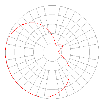 | ||||||||||||||||||
| Azimuth | Ratio | Azimuth | Ratio | Azimuth | Ratio | Azimuth | Ratio | ||||||||||||
| 0 | 0.362 | 10 | 0.270 | 20 | 0.209 | 30 | 0.167 | ||||||||||||
| 40 | 0.198 | 50 | 0.239 | 60 | 0.261 | 70 | 0.223 | ||||||||||||
| 80 | 0.158 | 90 | 0.123 | 100 | 0.151 | 110 | 0.203 | ||||||||||||
| 120 | 0.321 | 130 | 0.462 | 140 | 0.570 | 150 | 0.696 | ||||||||||||
| 160 | 0.800 | 170 | 0.869 | 180 | 0.939 | 190 | 0.979 | ||||||||||||
| 200 | 0.996 | 210 | 0.999 | 220 | 0.999 | 230 | 0.999 | ||||||||||||
| 240 | 1.000 | 250 | 0.999 | 260 | 0.999 | 270 | 0.999 | ||||||||||||
| 280 | 0.990 | 290 | 0.970 | 300 | 0.925 | 310 | 0.876 | ||||||||||||
| 320 | 0.805 | 330 | 0.720 | 340 | 0.600 | 350 | 0.470 | ||||||||||||
Structure Registration Number 1047148 Structure Type: GTOWER Registered To: American Towers LLC Structure Address: 2700 Loop 323 Nne (090308) Tyler, TX County Name: Smith County ASR Issued: 06/30/2016 Date Built: 12/21/1998 Site Elevation: 147.2 m (483 ft.) Structure Height: 145.4 m (477 ft.) Height Overall: 152.1 m (499 ft.) Overall Height AMSL: 299.3 m (982 ft.) FAA Determination: 10/01/2015 FAA Study #: 2015-ASW-7373-OE FAA Circular #: 70/7460-1K Paint & Light FAA Chapters: 4, 8, 12 FAA CHAPTERS 4,8,12; 70/7460-1K WITH BIRD LIGHTING DEVIATION SPECIAL CONDITION. PRIOR STUDY 2010-ASW-2749-OE 32-21-52.1 N 95-16-20.5 W (NAD 83) 32-21-51.6 N 95-16-19.7 W (Converted to NAD 27) |
545 E. John Carpenter Freeway Suite 700 Irving, TX 75062 Phone: 972-373-8000 Corporation | Title: President Date: 03/04/2021 Application Certifier Warwick Communications, Inc. 316 Willow Glen Drive Oak Hill, VA 20171 Applicant Gregory L. Masters, Esq Wiley Rein Llp 1776 K Street, N.w. Washington, DC 20006 | |||||||||||||||||
| |||||||||||||||||||