
FCCInfo.com
A Service of Cavell, Mertz & Associates, Inc.
(855) FCC-INFO
|
|
|
Virtual Channel 21 |  |
|
||||||||||||||||||
|
|
Repacking Information: No changes Status: License Application Accepted: 03/05/2021 License Expires: 08/01/2021 File Number: -0000138027 FCC Website Links: LMS Facility Details This Application Other WPTA Applications Including Superseded Applications Mailing Address Correspondence for WPTA Correspondence related to application -0000138027 Service Contour - Open Street Map or USGS Map (41 dBu) Service Contour - KML / Google Earth (41 dBu) Public Inspection Files Rabbit Ears Info Search for WPTA Site Location: 41-06-07.6 N 85-11-03.6 W (NAD 83) Site Location: 41-06-07.4 N 85-11-03.7 W (Converted to NAD 27) ERP: 333 kW Polarization: Horizontally polarized HAAT: 206.4 m (677 ft.) Electrical Beam Tilt: 0.55 degrees R/C AGL: 205.7 m (675 ft.) R/C AMSL: 454.4 m (1491 ft.) Site Elevation: 248.7 m. (816 ft.) Height Overall*: 235 m (771 ft.) (* As Filed In This Application, may differ from ASR Data, Below.) Directional Antenna - Antenna Make/Model: Dielectric TFU-16WB-1-R S230 Antenna ID: 1004051 Polarization: Horizontally polarized | |||||||||||||||||||||
| Antenna Data for Antenna Id: 1004051 WPTA DX File: -0000138027 Dielectric - TFU-16WB-1-R S230 Service: DX Standard Pattern: Y Pattern and Field Values Include a 285° Clockwise Rotation | 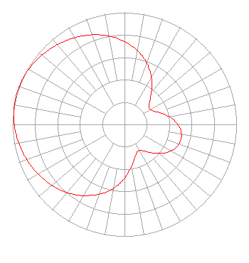 | |||||||||||||||||||||
| Azimuth | Ratio | Azimuth | Ratio | Azimuth | Ratio | Azimuth | Ratio | |||||||||||||||
| 5 | 0.707 | 15 | 0.627 | 25 | 0.532 | 35 | 0.427 | |||||||||||||||
| 45 | 0.327 | 55 | 0.266 | 65 | 0.284 | 75 | 0.360 | |||||||||||||||
| 85 | 0.443 | 95 | 0.501 | 105 | 0.522 | 115 | 0.501 | |||||||||||||||
| 125 | 0.443 | 135 | 0.361 | 145 | 0.287 | 155 | 0.270 | |||||||||||||||
| 165 | 0.330 | 175 | 0.429 | 185 | 0.533 | 195 | 0.627 | |||||||||||||||
| 205 | 0.699 | 215 | 0.767 | 225 | 0.822 | 235 | 0.868 | |||||||||||||||
| 245 | 0.908 | 255 | 0.943 | 265 | 0.972 | 275 | 0.992 | |||||||||||||||
| 285 | 1.000 | 295 | 0.994 | 305 | 0.975 | 315 | 0.947 | |||||||||||||||
| 325 | 0.913 | 335 | 0.873 | 345 | 0.828 | 355 | 0.773 | |||||||||||||||
Structure Registration Number 1306723 Structure Type: GTOWER Registered To: Gray Media Group, Inc. Structure Address: 3401 Butler Rd. Fort Wayne, IN County Name: Allen County ASR Issued: 08/03/2021 Date Built: 10/31/2018 Site Elevation: 248.7 m (816 ft.) Structure Height: 221.8 m (728 ft.) Height Overall: 235 m (771 ft.) Overall Height AMSL: 483.7 m (1587 ft.) FAA Determination: 05/21/2018 FAA Study #: 2018-AGL-6416-OE FAA Circular #: 70/7460-1L Paint & Light FAA Chapters: 3, 4, 5, 12 Removed expiration date from determination. Scenario 1./jjs/case#635066 41-06-07.6 N 85-11-03.6 W (NAD 83) 41-06-07.4 N 85-11-03.7 W (Converted to NAD 27) |
4370 Peachtree Road, Ne Atlanta, GA 30319 Phone: 404-504-9828 Limited Liability Company | Title: President Date: 03/05/2021 Application Certifier WPTA LICENSE, LLC Wpta License, Llc P.o. Box 909 Quincy, IL 62306 Applicant Stephen Hartzell Brooks, Pierce Et Al. 150 Fayetteville Street Suite 1700 Raleigh, NC 27601 Scott Turpie Lohnes & Culver, Llc Alexandria, VA 22302 Sr. Technical Consultant | ||||||||||||||||||||
|
| |||||||||||||||||||||