
FCCInfo.com
A Service of Cavell, Mertz & Associates, Inc.
(855) FCC-INFO
|
|
KHHI-LD from 07/01/1996 KHHI-LD from 09/30/1993 |
|
|
||||||||||||||||
|
|
Status: Construction Permit Application Accepted: 03/22/2021 KHHI-LD CP Expires: 03/25/2024 File Number: -0000140588 FCC Website Links: LMS Facility Details This Application Other KHHI-LD Applications Including Superseded Applications Mailing Address Correspondence for KHHI-LD Correspondence related to application -0000140588 Service Contour - Open Street Map or USGS Map (51 dBu) Service Contour - KML / Google Earth (51 dBu) Rabbit Ears Info Search for KHHI-LD Site Location: 21-23-33.6 N 158-05-48.1 W (NAD 83) Site Location: 21-23-45.0 N 158-05-58.0 W (Converted to NAD 27) ERP: 12.3 kW Polarization: Horizontally polarized Electrical Beam Tilt: 0.5 degrees R/C AGL: 10.1 m (33 ft.) R/C AMSL: 705.2 m (2314 ft.) Emission Mask: Stringent Site Elevation: 695.1 m. (2281 ft.) Height Overall*: 60.6 m (199 ft.) (* As Filed In This Application, may differ from ASR Data, Below.) Directional Antenna - Antenna Make/Model: Dielectric TUM-C1-02/02M-T Custom Antenna ID: 1001909 Polarization: Horizontally polarized | ||||||||||||||||||
| Antenna Data for Antenna Id: 1001909 KHHI-LD LD File: -0000140588 Dielectric - TUM-C1-02/02M-T Custom Service: LD Standard Pattern: Y | 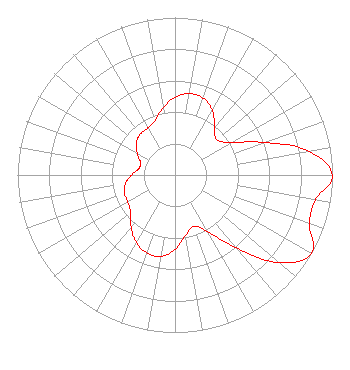 | ||||||||||||||||||
| Azimuth | Ratio | Azimuth | Ratio | Azimuth | Ratio | Azimuth | Ratio | ||||||||||||
| 0 | 0.493 | 10 | 0.525 | 20 | 0.520 | 30 | 0.474 | ||||||||||||
| 40 | 0.390 | 50 | 0.347 | 60 | 0.413 | 70 | 0.605 | ||||||||||||
| 80 | 0.867 | 90 | 1.000 | 100 | 0.907 | 110 | 0.907 | ||||||||||||
| 120 | 1.000 | 130 | 0.867 | 140 | 0.605 | 150 | 0.413 | ||||||||||||
| 160 | 0.347 | 170 | 0.390 | 180 | 0.474 | 190 | 0.525 | ||||||||||||
| 200 | 0.525 | 210 | 0.493 | 220 | 0.434 | 230 | 0.369 | ||||||||||||
| 240 | 0.345 | 250 | 0.341 | 260 | 0.320 | 270 | 0.277 | ||||||||||||
| 280 | 0.233 | 290 | 0.233 | 300 | 0.277 | 310 | 0.320 | ||||||||||||
| 320 | 0.341 | 330 | 0.345 | 340 | 0.369 | 350 | 0.434 | ||||||||||||
Structure Registration Number 1218023 Structure Type: TOWER Registered To: Salem Media of Hawaii Structure Address: Palikea Ridge, 26.9 Km Nw Of Honolulu At 292° True Makakilo, HI County Name: Honolulu County ASR Issued: 10/03/2000 Date Built: 10/03/2000 Site Elevation: 695.1 m (2281 ft.) Structure Height: 60.6 m (199 ft.) Height Overall: 60.6 m (199 ft.) Overall Height AMSL: 755.7 m (2479 ft.) FAA Determination: 09/08/2000 FAA Study #: 00-AWP-2258-OE Paint & Light FAA Chapters: NONE 21-23-33.6 N 158-05-48.1 W (NAD 83) 21-23-45.0 N 158-05-58.0 W (Converted to NAD 27) |
P.o. Box 3041 Jena, LA 71342 Phone: 318-992-7766 Limited Liability Company | Title: Member/manager Date: 03/22/2021 Application Certifier U.S. TELEVISION, L.L.C. U.s. Television, L.l.c. P.o. Box 3041 Jena, LA 71342 Applicant Susan Hansen B. W. St. Clair 2305 Vida Shaw Rd. New Iberia, LA 70563 Consultant DEAN M. MOSELY U.s. Television Llc P.o. Box 3045 Jena, LA 71342 | |||||||||||||||||