
FCCInfo.com
A Service of Cavell, Mertz & Associates, Inc.
(855) FCC-INFO
|
|
WDMY-LD from 08/20/2017 WDMY-LD from 08/11/2005 WDMY-LD from 12/05/1990 |
|
|
||||||||||||||||
|
|
Status: STA – Special Temporary Authority Application Accepted: 04/01/2021 STA Expires: 10/16/2021 File Number: -0000142690 FCC Website Links: LMS Facility Details This Application Other WDMY-LD Applications Including Superseded Applications Mailing Address Correspondence for WDMY-LD Correspondence related to application -0000142690 Service Contour - Open Street Map or USGS Map (74 dBu) Service Contour - KML / Google Earth (74 dBu) Rabbit Ears Info Search for WDMY-LD Site Location: 41-38-48.7 N 83-36-17.7 W (NAD 83) Site Location: 41-38-48.5 N 83-36-17.9 W (Converted to NAD 27) ERP: 8.2 kW R/C AGL: 123 m (404 ft.) R/C AMSL: 309.8 m (1016 ft.) Site Elevation: 186.8 m. (613 ft.) Height Overall*: 134.2 m (440 ft.) (* As Filed In This Application, may differ from ASR Data, Below.) Directional Antenna - Antenna Make/Model: Propagation System Inc CUSTOM ARRAY Antenna ID: 69669 | ||||||||||||||||||
| Antenna Data for Antenna Id: 69669 WDMY-LD TX File: -0000142690 Propagation System Inc - CUSTOM ARRAY Service: TX Standard Pattern: Y Pattern and Field Values Include a 123° Clockwise Rotation | 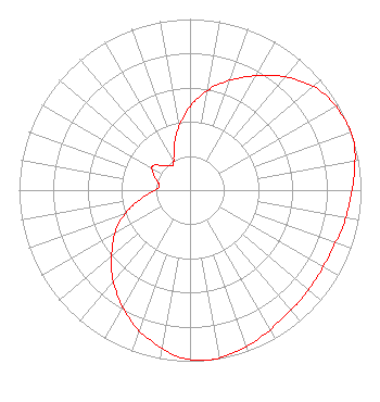 | ||||||||||||||||||
| Azimuth | Ratio | Azimuth | Ratio | Azimuth | Ratio | Azimuth | Ratio | ||||||||||||
| 3 | 0.520 | 13 | 0.620 | 23 | 0.710 | 33 | 0.800 | ||||||||||||
| 43 | 0.890 | 53 | 0.960 | 63 | 0.990 | 69 | 1.000 | ||||||||||||
| 73 | 1.000 | 83 | 0.970 | 93 | 0.940 | 103 | 0.920 | ||||||||||||
| 113 | 0.900 | 123 | 0.900 | 133 | 0.910 | 143 | 0.920 | ||||||||||||
| 153 | 0.950 | 163 | 0.980 | 173 | 1.000 | 174 | 1.000 | ||||||||||||
| 183 | 0.980 | 193 | 0.920 | 203 | 0.850 | 213 | 0.760 | ||||||||||||
| 223 | 0.670 | 233 | 0.570 | 243 | 0.480 | 253 | 0.370 | ||||||||||||
| 263 | 0.260 | 273 | 0.190 | 278 | 0.180 | 283 | 0.190 | ||||||||||||
| 293 | 0.230 | 303 | 0.260 | 313 | 0.210 | 323 | 0.180 | ||||||||||||
| 326 | 0.180 | 333 | 0.210 | 343 | 0.300 | 353 | 0.410 | ||||||||||||
Structure Registration Number 1054371 Structure Type: GTOWER Registered To: American Towers LLC Structure Address: Ne Of Westwood Ave. & Nebraska Ave. (westwood 1 Of 2 #50923) Toledo, OH County Name: Lucas County ASR Issued: 05/16/2013 Date Built: 05/10/2002 Site Elevation: 186.8 m (613 ft.) Structure Height: 132.6 m (435 ft.) Height Overall: 134.2 m (440 ft.) Overall Height AMSL: 321 m (1053 ft.) FAA Determination: 04/29/2013 FAA Study #: 2013-AGL-3740-OE FAA Circular #: 70/7460-1K Paint & Light FAA Chapters: 4, 8, 12 OM&L to remain the same as prior study = A MED-DUAL SYSTEM 41-38-48.7 N 83-36-17.7 W (NAD 83) 41-38-48.5 N 83-36-17.9 W (Converted to NAD 27) |
3434 W Kilbourn Ave. Milwaukee, WI 53208 Phone: 414-935-3000 Not-for-Profit | Title: Vice President Of Communications Date: 04/01/2021 Application Certifier Vcy America, Inc. 3434 W Kilbourn Ave. Milwaukee, WI 53208 Applicant Kathryne Dickerson Wiley Rein Llp 1776 K Street Nw Washington, DC 20006 | |||||||||||||||||