
FCCInfo.com
A Service of Cavell, Mertz & Associates, Inc.
(855) FCC-INFO
|
|
KVGA-LD from 05/26/2006 KVGA-LD from 12/04/1998 |
|
|
||||||||||||||||
|
|
Status: Construction Permit Application Accepted: 04/20/2021 KVGA-LD CP Expires: 04/26/2024 File Number: -0000143685 FCC Website Links: LMS Facility Details This Application Other KVGA-LD Applications Including Superseded Applications Mailing Address Correspondence for KVGA-LD Correspondence related to application -0000143685 Service Contour - Open Street Map or USGS Map (48 dBu) Service Contour - KML / Google Earth (48 dBu) Rabbit Ears Info Search for KVGA-LD Site Location: 36-00-34.4 N 115-00-23.0 W (NAD 83) Site Location: 36-00-34.5 N 115-00-20.0 W (Converted to NAD 27) ERP: 3 kW Polarization: Horizontally polarized R/C AGL: 14.8 m (49 ft.) R/C AMSL: 1006 m (3301 ft.) Emission Mask: Full Service Site Elevation: 991.2 m. (3252 ft.) Height Overall*: 77.1 m (253 ft.) (* As Filed In This Application, may differ from ASR Data, Below.) Directional Antenna - Antenna Make/Model: Propagation System Inc PSIVLP4MC Antenna ID: 1008094 Polarization: Horizontally polarized | ||||||||||||||||||
| Antenna Data for Antenna Id: 1008094 KVGA-LD LD File: -0000143685 Propagation System Inc - PSIVLP4MC Service: LD Standard Pattern: N Pattern and Field Values Include a 330° Clockwise Rotation | 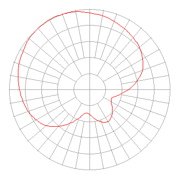 | ||||||||||||||||||
| Azimuth | Ratio | Azimuth | Ratio | Azimuth | Ratio | Azimuth | Ratio | ||||||||||||
| 0 | 0.950 | 10 | 0.930 | 20 | 0.900 | 30 | 0.870 | ||||||||||||
| 40 | 0.840 | 50 | 0.810 | 60 | 0.760 | 70 | 0.700 | ||||||||||||
| 80 | 0.600 | 90 | 0.490 | 100 | 0.380 | 110 | 0.300 | ||||||||||||
| 120 | 0.310 | 130 | 0.370 | 140 | 0.430 | 150 | 0.460 | ||||||||||||
| 160 | 0.430 | 170 | 0.370 | 180 | 0.310 | 190 | 0.300 | ||||||||||||
| 200 | 0.380 | 210 | 0.490 | 220 | 0.600 | 230 | 0.700 | ||||||||||||
| 240 | 0.760 | 250 | 0.810 | 260 | 0.840 | 270 | 0.870 | ||||||||||||
| 280 | 0.900 | 290 | 0.930 | 300 | 0.950 | 310 | 0.980 | ||||||||||||
| 320 | 0.990 | 330 | 1.000 | 340 | 0.990 | 350 | 0.980 | ||||||||||||
Structure Registration Number 1304131 Structure Type: LTOWER Registered To: American Towers LLC Structure Address: Black Mountain Road .7 Miles West Of I-515 (280506 Black Mt Twr 12) Henderson, NV County Name: Clark County ASR Issued: 04/23/2018 Date Built: 11/21/2017 Site Elevation: 991.2 m (3252 ft.) Structure Height: 61.3 m (201 ft.) Height Overall: 77.1 m (253 ft.) Overall Height AMSL: 1068.3 m (3505 ft.) FAA Determination: 04/20/2018 FAA Study #: 2017-AWP-12572-OE FAA Circular #: 70/7460-1L Paint & Light FAA Chapters: 4, 6, 12 OM&L to remain the same as prior study = 24-HR MED-STROBES 36-00-34.4 N 115-00-23.0 W (NAD 83) 36-00-34.5 N 115-00-20.0 W (Converted to NAD 27) |
Chattanooga, TN 37401 Phone: 423-468-5100 Limited Liability Company | Title: Coo Date: 04/20/2021 Application Certifier DIGITAL NETWORKS - SOUTHWEST, LLC Digital Networks - Southwest, Llc Chattanooga, TN 37401 Applicant Aaron P Shainis, Esq Shainis And Peltzman, Chartered 1850 M Street Nw Suite 240 Washington, DC 20036 FCC Legal Counsel Jeremy D Ruck, PE Jeremy Ruck & Associates, Inc. Canton, IL 61520 Consulting Engineer | |||||||||||||||||