
FCCInfo.com
A Service of Cavell, Mertz & Associates, Inc.
(855) FCC-INFO
|
|
K24OJ-D from 01/29/2020 K24OJ-D from 01/24/2020 K24OJ-D from 09/24/1986 |
|
|
||||||||||||||||
|
|
Status: License Application Accepted: 05/07/2021 License Expires: 08/01/2022 File Number: -0000144803 FCC Website Links: LMS Facility Details This Application Other K24OJ-D Applications Including Superseded Applications Mailing Address Correspondence for K24OJ-D Correspondence related to application -0000144803 Service Contour - Open Street Map or USGS Map (51 dBu) Service Contour - KML / Google Earth (51 dBu) Rabbit Ears Info Search for K24OJ-D Site Location: 29-31-55.3 N 99-44-40.1 W (NAD 83) Site Location: 29-31-54.5 N 99-44-38.9 W (Converted to NAD 27) ERP: 4.28 kW Polarization: Horizontally polarized R/C AGL: 30.5 m (100 ft.) R/C AMSL: 519.4 m (1704 ft.) Emission Mask: Full Service Site Elevation: 488.9 m. (1604 ft.) Height Overall*: 103.6 m (340 ft.) (* As Filed In This Application, may differ from ASR Data, Below.) Directional Antenna - Antenna Make/Model: Scala PR-TV x2 Array 1@60 1@190 Antenna ID: 1008168 Polarization: Horizontally polarized | ||||||||||||||||||
| Antenna Data for Antenna Id: 1008168 K24OJ-D LD File: -0000144803 Scala - PR-TV x2 Array 1@60 1@190 Service: LD Standard Pattern: N | 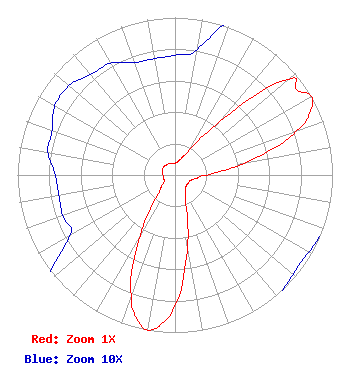 | ||||||||||||||||||
| Azimuth | Ratio | Azimuth | Ratio | Azimuth | Ratio | Azimuth | Ratio | ||||||||||||
| 0 | 0.076 | 10 | 0.081 | 20 | 0.112 | 30 | 0.186 | ||||||||||||
| 40 | 0.442 | 50 | 0.944 | 55 | 0.944 | 60 | 1.000 | ||||||||||||
| 65 | 0.948 | 70 | 0.820 | 80 | 0.458 | 90 | 0.202 | ||||||||||||
| 100 | 0.132 | 110 | 0.104 | 120 | 0.098 | 130 | 0.098 | ||||||||||||
| 140 | 0.104 | 150 | 0.132 | 160 | 0.202 | 170 | 0.458 | ||||||||||||
| 180 | 0.820 | 185 | 0.948 | 190 | 1.000 | 195 | 0.944 | ||||||||||||
| 200 | 0.813 | 210 | 0.442 | 220 | 0.186 | 230 | 0.112 | ||||||||||||
| 240 | 0.077 | 250 | 0.076 | 260 | 0.075 | 270 | 0.076 | ||||||||||||
| 280 | 0.082 | 290 | 0.083 | 300 | 0.088 | 310 | 0.088 | ||||||||||||
| 320 | 0.083 | 330 | 0.082 | 340 | 0.076 | 350 | 0.075 | ||||||||||||
Structure Registration Number 1064284 Structure Type: TOWER Registered To: TEXAS RSA 18 TOWER HOLDINGS, L.P. Structure Address: Rt. 70, Box 445 Uvalde, TX County Name: Uvalde County ASR Issued: 11/21/2022 Date Built: 09/07/1999 Site Elevation: 488.9 m (1604 ft.) Structure Height: 97.8 m (321 ft.) Height Overall: 103.6 m (340 ft.) Overall Height AMSL: 592.5 m (1944 ft.) FAA Determination: 02/09/1999 FAA Study #: 99-ASW-0138-OE FAA Circular #: 70/7460-1J Paint & Light FAA Chapters: 4, 8, 13 Removed expiration date from determination. Scenario 1./jjs/case#635066 29-31-55.3 N 99-44-40.1 W (NAD 83) 29-31-54.5 N 99-44-38.9 W (Converted to NAD 27) |
Chattanooga, TN 37401 Phone: 423-468-5100 Limited Liability Company | Title: Coo Date: 05/07/2021 Application Certifier DIGITAL NETWORKS-SOUTHWEST, LLC Digital Networks-southwest, Llc Chattanooga, TN 37401 Applicant Jeremy D Ruck, PE Jeremy Ruck & Associates, Inc. Canton, IL 61520 Consulting Engineer Aaron P Shainis Shainis & Peltzman, Chartered 1850 M St. Nw Suite 240 Washington, DC 20036 FCC Legal Counsel | |||||||||||||||||