
FCCInfo.com
A Service of Cavell, Mertz & Associates, Inc.
(855) FCC-INFO
|
|
W30EB-D from 06/24/2021 W30EB-D from 01/12/2007 |
|
|
||||||||||||||||
|
|
Status: License Application Accepted: 06/21/2021 License Expires: 08/01/2023 File Number: -0000150592 FCC Website Links: LMS Facility Details This Application Other WRLD-LD Applications Including Superseded Applications Mailing Address Correspondence for WRLD-LD Correspondence related to application -0000150592 Service Contour - Open Street Map or USGS Map (51 dBu) Service Contour - KML / Google Earth (51 dBu) Rabbit Ears Info Search for WRLD-LD Site Location: 41-18-53.8 N 75-53-18.1 W (NAD 83) Site Location: 41-18-53.5 N 75-53-19.4 W (Converted to NAD 27) ERP: 9.5 kW Polarization: Horizontally polarized Electrical Beam Tilt: 1.75 degrees R/C AGL: 26 m (85 ft.) R/C AMSL: 498.3 m (1635 ft.) Emission Mask: Full Service Site Elevation: 472.3 m. (1550 ft.) Height Overall*: 29.9 m (98 ft.) (* As Filed In This Application, may differ from ASR Data, Below.) Directional Antenna - Antenna Make/Model: Electronics Research Inc. AL8 Antenna ID: 1008312 Polarization: Horizontally polarized | ||||||||||||||||||
| Antenna Data for Antenna Id: 1008312 WRLD-LD LD File: -0000150592 Electronics Research Inc. - AL8 Service: LD Standard Pattern: N | 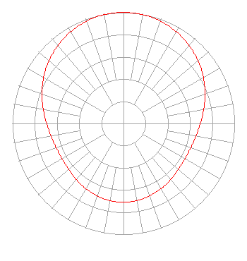 | ||||||||||||||||||
| Azimuth | Ratio | Azimuth | Ratio | Azimuth | Ratio | Azimuth | Ratio | ||||||||||||
| 0 | 1.000 | 10 | 0.995 | 20 | 0.979 | 30 | 0.953 | ||||||||||||
| 40 | 0.918 | 50 | 0.876 | 60 | 0.829 | 70 | 0.780 | ||||||||||||
| 80 | 0.733 | 90 | 0.692 | 100 | 0.662 | 110 | 0.644 | ||||||||||||
| 120 | 0.639 | 130 | 0.646 | 140 | 0.661 | 150 | 0.678 | ||||||||||||
| 160 | 0.694 | 170 | 0.705 | 180 | 0.709 | 190 | 0.705 | ||||||||||||
| 200 | 0.694 | 210 | 0.678 | 220 | 0.661 | 230 | 0.646 | ||||||||||||
| 240 | 0.639 | 250 | 0.644 | 260 | 0.662 | 270 | 0.692 | ||||||||||||
| 280 | 0.733 | 290 | 0.780 | 300 | 0.829 | 310 | 0.876 | ||||||||||||
| 320 | 0.918 | 330 | 0.953 | 340 | 0.979 | 350 | 0.995 | ||||||||||||
Structure Registration Number 1205031 Structure Type: TOWER Structure Address: Approx .4km Southeast Of Bunker Hill Rd. Kingston Twp., PA County Name: Luzerne County ASR Issued: 10/08/2010 Date Built: 12/31/1992 Site Elevation: 472.3 m (1550 ft.) Structure Height: 29.9 m (98 ft.) Height Overall: 29.9 m (98 ft.) Overall Height AMSL: 502.2 m (1648 ft.) FAA Determination: 09/10/1999 FAA Study #: 99-AEA-2276-OE FAA Circular #: 70/7460-1J Paint & Light FAA Chapters: 3, 4, 5, 13 Removed expiration date from determination. Scenario 1./jjs/case#635066 41-18-53.8 N 75-53-18.1 W (NAD 83) 41-18-53.5 N 75-53-19.4 W (Converted to NAD 27) |
Bear Creek Township, PA 18702 Phone: 570-574-0404 Individual | Title: Sole Proprietor Date: 06/21/2021 Application Certifier 444 Crescent Road Bear Creek Township, PA 18702 Applicant Joseph C Chautin Hardy, Carey, Chautin & Balkin, Llp 1080 West Causeway Approach Mandeville, LA 70471 William Jeffrey Reynolds Du Treil, Lundin & Rackley, Inc. 3135 Southgate Circle Sarasota, FL 34239 Technical Consultant | |||||||||||||||||