
FCCInfo.com
A Service of Cavell, Mertz & Associates, Inc.
(855) FCC-INFO
|
|
WUNW from 09/19/1996 |
Virtual Channel 27 |  |
|
||||||||||||||||||||
|
|
Repacking Information: No changes Status: License Application Accepted: 02/21/2024 License Expires: 12/01/2028 File Number: -0000163367 FCC Website Links: LMS Facility Details This Application Other WUNW Applications Including Superseded Applications Mailing Address Correspondence for WUNW Correspondence related to application -0000163367 Service Contour - Open Street Map or USGS Map (41 dBu) Service Contour - KML / Google Earth (41 dBu) Public Inspection Files Rabbit Ears Info Search for WUNW DTS Site Number: 1 Site Location: 35-34-07.0 N 82-54-26.2 W (NAD 83) Site Location: 35-34-06.6 N 82-54-26.7 W (Converted to NAD 27) ERP: 115 kW Polarization: Elliptically polarized HAAT: 504.9 m (1656 ft.) Electrical Beam Tilt: 3 degrees R/C AGL: 55 m (180 ft.) R/C AMSL: 1421 m (4662 ft.) Site Elevation: 1366 m. (4482 ft.) Height Overall*: 59 m (194 ft.) (* As Filed In This Application, may differ from ASR Data, Below.) Directional Antenna - Antenna Make/Model: Dielectric TFU-10DSB/VP-B-R Antenna ID: 1007634 Polarization: Elliptically polarized
| |||||||||||||||||||||||
| Antenna Data for Antenna Id: 1007634 WUNW DD File: -0000163367 Dielectric - TFU-10DSB/VP-B-R Service: DD Standard Pattern: N | 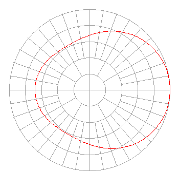 | |||||||||||||||||||||||
| Azimuth | Ratio | Azimuth | Ratio | Azimuth | Ratio | Azimuth | Ratio | |||||||||||||||||
| 0 | 0.675 | 10 | 0.721 | 20 | 0.772 | 30 | 0.824 | |||||||||||||||||
| 40 | 0.873 | 50 | 0.917 | 60 | 0.952 | 70 | 0.979 | |||||||||||||||||
| 80 | 0.995 | 90 | 1.000 | 100 | 0.995 | 110 | 0.979 | |||||||||||||||||
| 120 | 0.952 | 130 | 0.917 | 140 | 0.873 | 150 | 0.824 | |||||||||||||||||
| 160 | 0.772 | 170 | 0.721 | 180 | 0.675 | 190 | 0.639 | |||||||||||||||||
| 200 | 0.616 | 210 | 0.608 | 220 | 0.613 | 230 | 0.627 | |||||||||||||||||
| 240 | 0.644 | 250 | 0.660 | 260 | 0.672 | 270 | 0.676 | |||||||||||||||||
| 280 | 0.672 | 290 | 0.660 | 300 | 0.644 | 310 | 0.627 | |||||||||||||||||
| 320 | 0.613 | 330 | 0.608 | 340 | 0.616 | 350 | 0.639 | |||||||||||||||||
Structure Registration Number 1275765 Structure Type: TOWER Registered To: University of North Carolina Structure Address: Atop Chambers Mountain, Lookout Tower Road Clyde, NC County Name: Haywood County ASR Issued: 09/01/2010 Date Built: 06/03/2011 Site Elevation: 1366 m (4482 ft.) Structure Height: 59 m (194 ft.) Height Overall: 59 m (194 ft.) Overall Height AMSL: 1425 m (4675 ft.) FAA Determination: 08/31/2010 FAA Study #: 2010-ASO-4238-OE Paint & Light FAA Chapters: NONE Removed expiration date from determination. Scenario 1./jjs/case#635066 35-34-07.0 N 82-54-26.2 W (NAD 83) 35-34-06.6 N 82-54-26.7 W (Converted to NAD 27) |
10 Unc-tv Drive Research Triangle Park, NC 27709 Phone: 919-549-7000 Government Entity | Title: Chief Operating Officer Date: 10/08/2021 Application Certifier University of North Carolina University Of North Carolina 10 Unc-tv Drive Research Triangle Park, NC 27709 Applicant Donald W Smith University Of North Carolina 10 Unc-tv Drive Research Triangle Park, NC 27709 Joseph M. Davis, P.E. Chesapeake Rf Consultants, Llc 207 Old Dominion Road Yorktown, VA 23692 Consulting Engineer Stephen Hartzell Brooks, Pierce Et Al. 150 Fayetteville Street Suite 1700 Raleigh, NC 27601 Marcus W Trathen Brooks, Pierce Et Al. 150 Fayetteville Street Suite 1700 Raleigh, NC 27601 | ||||||||||||||||||||||