
FCCInfo.com
A Service of Cavell, Mertz & Associates, Inc.
(855) FCC-INFO
|
|
K08KA-D from 06/14/1982 |
|
|
||||||||||||||||
|
|
Status: License Application Accepted: 06/21/2021 License Expires: 02/01/2023 File Number: -0000150561 FCC Website Links: LMS Facility Details This Application Other K08KA-D Applications Including Superseded Applications Mailing Address Correspondence for K08KA-D Correspondence related to application -0000150561 Service Contour - Open Street Map or USGS Map (48 dBu) Service Contour - KML / Google Earth (48 dBu) Rabbit Ears Info Search for K08KA-D Site Location: 60-57-09.9 N 149-06-36.0 W (NAD 83) Site Location: 60-57-12.0 N 149-06-28.2 W (Converted to NAD 27) ERP: 0.3 kW Polarization: Horizontally polarized R/C AGL: 5 m (16 ft.) R/C AMSL: 244.3 m (802 ft.) Emission Mask: Simple Site Elevation: 239.3 m. (785 ft.) Height Overall*: 15.2 m (50 ft.) (* As Filed In This Application, may differ from ASR Data, Below.) Directional Antenna - Antenna Make/Model: Scala CL-713 Antenna ID: 20786 Polarization: Horizontally polarized
| ||||||||||||||||||
| Antenna Data for Antenna Id: 20786 K08KA-D LD File: -0000150561 Scala - CL-713 Service: LD Standard Pattern: Y Pattern and Field Values Include a 305° Clockwise Rotation | 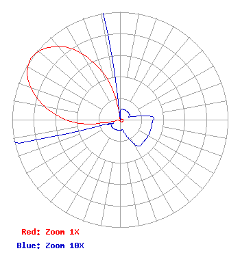 | ||||||||||||||||||
| Azimuth | Ratio | Azimuth | Ratio | Azimuth | Ratio | Azimuth | Ratio | ||||||||||||
| 5 | 0.010 | 15 | 0.010 | 25 | 0.010 | 35 | 0.010 | ||||||||||||
| 45 | 0.010 | 55 | 0.010 | 65 | 0.010 | 75 | 0.010 | ||||||||||||
| 85 | 0.030 | 95 | 0.030 | 105 | 0.030 | 115 | 0.030 | ||||||||||||
| 125 | 0.030 | 135 | 0.030 | 145 | 0.030 | 155 | 0.020 | ||||||||||||
| 165 | 0.010 | 175 | 0.010 | 185 | 0.010 | 195 | 0.010 | ||||||||||||
| 205 | 0.010 | 215 | 0.010 | 225 | 0.010 | 235 | 0.010 | ||||||||||||
| 245 | 0.010 | 255 | 0.050 | 265 | 0.380 | 275 | 0.606 | ||||||||||||
| 285 | 0.800 | 295 | 0.945 | 305 | 1.000 | 315 | 0.945 | ||||||||||||
| 325 | 0.810 | 335 | 0.590 | 345 | 0.325 | 355 | 0.010 | ||||||||||||
Structure Registration Number 1250065 Structure Type: TOWER Registered To: State of Alaska Structure Address: South Side Of Mt Alyeska At The 785 Foot Elevation Girdwood, AK County Name: Anchorage Municipality ASR Issued: 09/10/2015 Date Built: 09/12/2005 Site Elevation: 239.3 m (785 ft.) Structure Height: 15.2 m (50 ft.) Height Overall: 15.2 m (50 ft.) Overall Height AMSL: 254.5 m (835 ft.) FAA Determination: 09/02/2005 FAA Study #: 2005-AAL-191-OE Paint & Light FAA Chapters: NONE 60-57-09.9 N 149-06-36.0 W (NAD 83) 60-57-12.0 N 149-06-28.2 W (Converted to NAD 27) |
2750 Luberon Lane Cumming, GA 30041 Phone: 678-777-8659 Limited Liability Company | Title: Officer Date: 06/21/2021 Application Certifier KTBY LICENSE LLC Ktby License Llc 2750 Luberon Lane Cumming, GA 30041 Applicant Daniel Kirkpatrick Baker & Hostetler, Llp 1050 Connecticut Ave Nw Suite 1100 Washington, DC 20036 | |||||||||||||||||