
FCCInfo.com
A Service of Cavell, Mertz & Associates, Inc.
(855) FCC-INFO
|
|
W29ES-D from 10/11/2018 W29ES-D from 02/25/2010 |
|
|
||||||||||||||||
|
|
Status: License Application Accepted: 06/24/2021 License Expires: 12/01/2021 File Number: -0000150934 FCC Website Links: LMS Facility Details This Application Other W29ES-D Applications Including Superseded Applications Mailing Address Correspondence for W29ES-D Correspondence related to application -0000150934 Service Contour - Open Street Map or USGS Map (51 dBu) Service Contour - KML / Google Earth (51 dBu) Rabbit Ears Info Search for W29ES-D Site Location: 39-36-09.6 N 90-02-46.3 W (NAD 83) Site Location: 39-36-09.4 N 90-02-45.9 W (Converted to NAD 27) ERP: 15 kW Polarization: Elliptically polarized Electrical Beam Tilt: 1.25 degrees R/C AGL: 264 m (866 ft.) R/C AMSL: 469.4 m (1540 ft.) Emission Mask: Simple Site Elevation: 205.4 m. (674 ft.) Height Overall*: 297.5 m (976 ft.) (* As Filed In This Application, may differ from ASR Data, Below.) Directional Antenna - Antenna Make/Model: Electronics Research Inc. AL12-29-PLE Antenna ID: 1008328 Polarization: Elliptically polarized
| ||||||||||||||||||
| Antenna Data for Antenna Id: 1008328 W29ES-D LD File: -0000150934 Electronics Research Inc. - AL12-29-PLE Service: LD Standard Pattern: N Pattern and Field Values Include a 320° Clockwise Rotation | 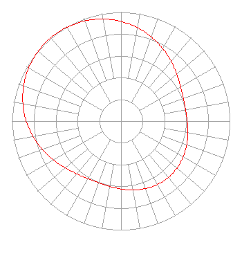 | ||||||||||||||||||
| Azimuth | Ratio | Azimuth | Ratio | Azimuth | Ratio | Azimuth | Ratio | ||||||||||||
| 0 | 0.915 | 10 | 0.871 | 20 | 0.820 | 30 | 0.767 | ||||||||||||
| 40 | 0.715 | 50 | 0.668 | 60 | 0.631 | 70 | 0.609 | ||||||||||||
| 80 | 0.602 | 90 | 0.608 | 100 | 0.623 | 110 | 0.642 | ||||||||||||
| 120 | 0.659 | 130 | 0.672 | 140 | 0.676 | 150 | 0.672 | ||||||||||||
| 160 | 0.659 | 170 | 0.642 | 180 | 0.623 | 190 | 0.608 | ||||||||||||
| 200 | 0.602 | 210 | 0.609 | 220 | 0.631 | 230 | 0.668 | ||||||||||||
| 240 | 0.715 | 250 | 0.767 | 260 | 0.820 | 270 | 0.871 | ||||||||||||
| 280 | 0.915 | 290 | 0.951 | 300 | 0.978 | 310 | 0.994 | ||||||||||||
| 320 | 1.000 | 330 | 0.994 | 340 | 0.978 | 350 | 0.951 | ||||||||||||
Structure Registration Number 1317186 Structure Type: GTOWER Registered To: K2 Towers II, LLC Structure Address: 562 Harts Prairie Rd Franklin, IL County Name: Morgan County ASR Issued: 05/03/2022 Date Built: 07/01/2020 Site Elevation: 205.4 m (674 ft.) Structure Height: 276.8 m (908 ft.) Height Overall: 297.5 m (976 ft.) Overall Height AMSL: 502.9 m (1650 ft.) FAA Determination: 12/13/2000 FAA Study #: 00-AGL-2187-OE FAA Circular #: 70/7460-1K Paint & Light FAA Chapters: 4, 9, 12 Removed expiration date from determination. Scenario 1./jjs/case#635066 39-36-09.6 N 90-02-46.3 W (NAD 83) 39-36-09.4 N 90-02-45.9 W (Converted to NAD 27) |
405 Madison Ave. Suite 2100 Toledo, OH 43604 Phone: 419-724-6212 Corporation | Title: President And General Manager Date: 06/24/2021 Application Certifier WAND(TV) PARTNERSHIP Wand(tv) Partnership 904 South Side Drive Decatur, IL 62521 Applicant Christina H Burrow Cooley Llp 1299 Pennsylvania Avenue, Nw Suite 700 Washington, DC 20004 Legal Representative DONALD G Everist Cohen, Dippell And Everist, P.c. Cohen, Dippell And Everist, P.c. 1420 N Street, Nw Suite One Washington, DC 20005 CONSULTING ENGINEER Greg Yadon Wand(tv) Partnership Wand(tv) Partnership 904 South Side Drive Decatur, IL 62521 Chief Engineer | |||||||||||||||||