
FCCInfo.com
A Service of Cavell, Mertz & Associates, Inc.
(855) FCC-INFO
|
|
KTEL-TV from 11/28/1997 KTEL-TV from 10/27/1997 |
Virtual Channel 25 |  |
|
||||||||||||||||||||||||
|
|
Repacking Information: No changes Status: License Application Accepted: 06/28/2021 License Expires: 10/01/2022 File Number: -0000151164 FCC Website Links: LMS Facility Details This Application Other KTEL-TV Applications Including Superseded Applications Mailing Address Correspondence for KTEL-TV Correspondence related to application -0000151164 Service Contour - Open Street Map or USGS Map (41 dBu) Service Contour - KML / Google Earth (41 dBu) Public Inspection Files Rabbit Ears Info Search for KTEL-TV Site Location: 32-26-09.6 N 104-11-16.0 W (NAD 83) Site Location: 32-26-09.2 N 104-11-14.2 W (Converted to NAD 27) ERP: 41 kW Polarization: Horizontally polarized HAAT: 120.4 m (395 ft.) Electrical Beam Tilt: 1 degree R/C AGL: 122 m (400 ft.) R/C AMSL: 1090.3 m (3577 ft.) Site Elevation: 968.3 m. (3177 ft.) Height Overall*: 137.5 m (451 ft.) (* As Filed In This Application, may differ from ASR Data, Below.) Directional Antenna - Antenna Make/Model: Andrew ALP16L4-HSOC-25 Antenna ID: 1008340 Polarization: Horizontally polarized
| |||||||||||||||||||||||||||
| Antenna Data for Antenna Id: 1008340 KTEL-TV DT File: -0000151164 Andrew - ALP16L4-HSOC-25 Service: DT Standard Pattern: N Pattern and Field Values Include a 245° Clockwise Rotation | 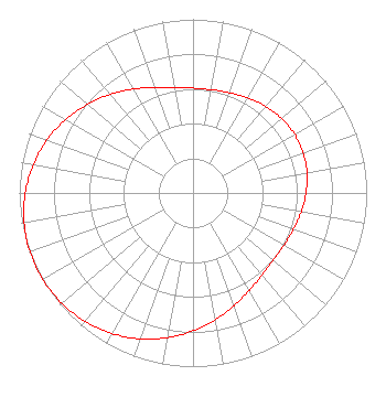 | |||||||||||||||||||||||||||
| Azimuth | Ratio | Azimuth | Ratio | Azimuth | Ratio | Azimuth | Ratio | |||||||||||||||||||||
| 5 | 0.602 | 15 | 0.608 | 25 | 0.623 | 35 | 0.642 | |||||||||||||||||||||
| 45 | 0.659 | 55 | 0.672 | 65 | 0.676 | 75 | 0.672 | |||||||||||||||||||||
| 85 | 0.659 | 95 | 0.642 | 105 | 0.623 | 115 | 0.608 | |||||||||||||||||||||
| 125 | 0.602 | 135 | 0.609 | 145 | 0.631 | 155 | 0.668 | |||||||||||||||||||||
| 165 | 0.715 | 175 | 0.767 | 185 | 0.820 | 195 | 0.871 | |||||||||||||||||||||
| 205 | 0.915 | 215 | 0.951 | 225 | 0.978 | 235 | 0.994 | |||||||||||||||||||||
| 245 | 1.000 | 255 | 0.994 | 265 | 0.978 | 275 | 0.951 | |||||||||||||||||||||
| 285 | 0.915 | 295 | 0.871 | 305 | 0.820 | 315 | 0.767 | |||||||||||||||||||||
| 325 | 0.715 | 335 | 0.668 | 345 | 0.631 | 355 | 0.609 | |||||||||||||||||||||
Structure Registration Number 1002840 Structure Type: GTOWER Registered To: American Towers LLC Structure Address: 1609 East Greene Street (#209753) Carlsbad, NM County Name: Eddy County ASR Issued: 12/17/2021 Date Built: 01/01/1990 Site Elevation: 968.3 m (3177 ft.) Structure Height: 134.4 m (441 ft.) Height Overall: 137.5 m (451 ft.) Overall Height AMSL: 1105.8 m (3628 ft.) FAA Determination: 12/07/2021 FAA Study #: 2021-ASW-11364-OE FAA Circular #: 70/7460-1M Paint & Light FAA Chapters: 4, 8, 15 PRIOR STUDY 2014-ASW-3512-OE 32-26-09.6 N 104-11-16.0 W (NAD 83) 32-26-09.2 N 104-11-14.2 W (Converted to NAD 27) |
300 New Jersey Avenue, Nw Suite 700 Washington, DC 20001 Phone: 202-524-6413 Limited Liability Company | Title: President Date: 06/28/2021 Application Certifier Ramar Communications, Inc. 9800 University Aveneue Po Box 3757 Lubbock, TX 79423 Applicant Dennis P. Corbett, Esq Telecommunications Law Professionals Pllc 1025 Connecticut Ave. Nw Suite 1011 Washington, DC 20036 Joseph M. Davis, P.E. Chesapeake Rf Consultants, Llc 207 Old Dominion Road Yorktown, VA 23692 Consulting Engineer | ||||||||||||||||||||||||||