
FCCInfo.com
A Service of Cavell, Mertz & Associates, Inc.
(855) FCC-INFO
|
|
WIVN-LD from 09/24/2004 WIVN-LD from 10/01/2001 |
|
|
||||||||||||||||
|
|
Status: License Application Accepted: 06/28/2021 License Expires: 08/01/2029 File Number: -0000151099 FCC Website Links: LMS Facility Details This Application Other WIVN-LD Applications Including Superseded Applications Mailing Address Correspondence for WIVN-LD Correspondence related to application -0000151099 Service Contour - Open Street Map or USGS Map (43 dBu) Service Contour - KML / Google Earth (43 dBu) Rabbit Ears Info Search for WIVN-LD Site Location: 40-21-31.8 N 81-30-01.5 W (NAD 83) Site Location: 40-21-31.6 N 81-30-02.1 W (Converted to NAD 27) ERP: 0.015 kW Polarization: Horizontally polarized R/C AGL: 15.2 m (50 ft.) R/C AMSL: 383.4 m (1258 ft.) Emission Mask: Stringent Site Elevation: 368.2 m. (1208 ft.) Height Overall*: 93.9 m (308 ft.) (* As Filed In This Application, may differ from ASR Data, Below.) Directional Antenna - Antenna Make/Model: Propagation System Inc PSILV5LOG-5 Antenna ID: 1008337 Polarization: Horizontally polarized
| ||||||||||||||||||
| Antenna Data for Antenna Id: 1008337 WIVN-LD LD File: -0000151099 Propagation System Inc - PSILV5LOG-5 Service: LD Standard Pattern: N | 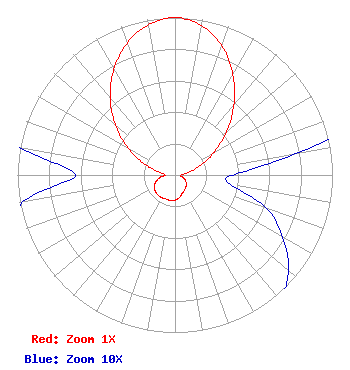 | ||||||||||||||||||
| Azimuth | Ratio | Azimuth | Ratio | Azimuth | Ratio | Azimuth | Ratio | ||||||||||||
| 0 | 1.000 | 10 | 0.963 | 20 | 0.872 | 30 | 0.735 | ||||||||||||
| 40 | 0.580 | 50 | 0.428 | 60 | 0.288 | 70 | 0.169 | ||||||||||||
| 80 | 0.078 | 90 | 0.037 | 100 | 0.036 | 110 | 0.062 | ||||||||||||
| 120 | 0.079 | 130 | 0.094 | 140 | 0.105 | 150 | 0.116 | ||||||||||||
| 160 | 0.128 | 170 | 0.147 | 180 | 0.160 | 190 | 0.164 | ||||||||||||
| 200 | 0.163 | 210 | 0.166 | 220 | 0.167 | 230 | 0.162 | ||||||||||||
| 240 | 0.153 | 250 | 0.131 | 260 | 0.098 | 270 | 0.063 | ||||||||||||
| 280 | 0.102 | 290 | 0.210 | 300 | 0.346 | 310 | 0.494 | ||||||||||||
| 320 | 0.640 | 330 | 0.776 | 340 | 0.891 | 350 | 0.969 | ||||||||||||
Structure Registration Number 1226927 Structure Type: TOWER Registered To: SpectraSite Communications, LLC. through American Towers, LLC. Structure Address: 8087 Hammond Hill Rd Sw (#307683) Port Washington, OH County Name: Tuscarawas County ASR Issued: 01/16/2013 Date Built: 09/14/2001 Site Elevation: 368.2 m (1208 ft.) Structure Height: 91.7 m (301 ft.) Height Overall: 93.9 m (308 ft.) Overall Height AMSL: 462.1 m (1516 ft.) FAA Determination: 04/12/2010 FAA Study #: 2010-AGL-1610-OE FAA Circular #: 70/7460-1K Paint & Light FAA Chapters: 4, 8, 12 OM&L to remain the same as prior study = A MED-DUAL SYSTEM 40-21-31.8 N 81-30-01.5 W (NAD 83) 40-21-31.6 N 81-30-02.1 W (Converted to NAD 27) |
6755 Freedom Ave., N.w. North Canton, OH 44720 Phone: 330-494-9303 Corporation | Title: President Date: 06/28/2021 Application Certifier IMAGE VIDEO TELEPRODUCTIONS, INC. Image Video Teleproductions, Inc. 6755 Freedom Ave., N.w. North Canton, OH 44720 Applicant Darryl K DeLawder Delawder Communications, Inc. P.o Box 1095 Ashburn, VA 20146 President Kathleen Victory Fletcher, Heald & Hildreth, P.l.c. 1300 N. 17th St. 11th Floor Arlington, VA 22209 FCC Counsel | |||||||||||||||||